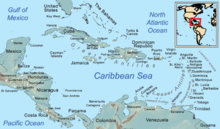
แคริบเบียน
14°31′32″N 75°49′06″W / 14.52556°N 75.81833°W
หน้านี้มีเนื้อหาเป็นภาษาต่างประเทศ คุณสามารถช่วยพัฒนาหน้านี้ได้ด้วยการแปล ยกเว้นหากเนื้อหาเกือบทั้งหมดไม่ใช่ภาษาไทย ให้แจ้งลบแทน |
บทความนี้อาจต้องการตรวจสอบต้นฉบับ ในด้านไวยากรณ์ รูปแบบการเขียน การเรียบเรียง คุณภาพ หรือการสะกด คุณสามารถช่วยพัฒนาบทความได้ |
 | |
| พื้นที่ | 239,681 ตารางกิโลเมตร (92,541 ตารางไมล์) |
|---|---|
| ประชากร | 43,601,839[1] |
| ความหนาแน่น | 151.5 ต่อตารางกิโลเมตร (392 ต่อตารางไมล์) |
| กลุ่มชาติพันธุ์ | แอฟริกัน, ละติโนหรือฮิสแปนิก (สเปน, โปนตุเกส, เมสติโซ, มูแลตโต, พารโด และซัมโบ), อินเดีย, ยุโรป, จีน, ยิว, อาหรับ, อเมรินเดีย, ชวา,[2] ม้ง, หลายเชื้อชาติ |
| ศาสนา | คริสต์, ฮินดู, อิสลาม, กลุ่มศาสนาแอฟโร-อเมริกัน, ศาสนาพื้นเมืองแอฟริกัน, ราสตาฟารี, ศาสนาพื้นเมืองอเมริกัน, ยูดาห์, พุทธ, ศาสนาพื้นบ้านจีน (รวมลัทธิเต๋าและลัทธิขงจื๊อ), บาไฮ, เกอบาตีนัน, ซิกข์, ไม่มีศาสนา, อื่น ๆ |
| เดมะนิม | ชาวแคริบเบียน, ชาวหมู่เกาะเวสต์อินดีส |
| ประเทศ | 13-16 |
| ดินแดน | 12 |
| ภาษา | |
| เขตเวลา | UTC−05:00 ถึง UTC−04:00 |
| โดเมนระดับบนสุด | หลายแบบ |
| รหัสโทรศัพท์ | หลายแบบ |
| เมืองใหญ่ | |
| รหัส UN M49 | 029 – แคริบเบียน419 – ละตินอเมริกาและแคริบเบียน019 – ทวีปอเมริกา001 – โลก |
แคริบเบียน (อังกฤษ: The Caribbean; สเปน: el Caribe; ฝรั่งเศส: les Caraïbes; ครีโอลเฮติ: Karayib; ดัตช์: de Caraïben) เป็นอนุภูมิภาคของทวีปอเมริกาที่ประกอบด้วยทะเลแคริบเบียนและหมู่เกาะ (บางเกาะล้อมรอบด้วยทะเลนี้[3] และบางเกาะติดทั้งทะเลแคริบเบียนและมหาสมุทรแอตแลนติกเหนือ)[4] โดยอาจรวมพื้นที่ชายฝั่งใกล้เคียงบนแผ่นดินใหญ่ด้วย ภูมิภาคนี้อยู่ทางตะวันออกเฉียงใต้ของอ่าวเม็กซิโกกับและทวีปอเมริกาเหนือแผ่นดินใหญ่ ทางตะวันออกของทวีปอเมริกากลาง และทางเหนือของทวีปอเมริกาใต้
ภูมิภาคนี้ส่วนใหญ่อยู่บนแผ่นแคริบเบียน และมีเกาะ เกาะเล็ก พืดหินใต้น้ำ และเกาะปริ่มน้ำมากกว่า 700 เกาะ (ดูรายการเกาะในแคริบเบียน) หมู่เกาะรูปโค้งกำหนดขอบด้านเหนือและด้านตะวันออกของทะเลแคริบเบียน[5] ได้แก่ เกรตเตอร์แอนทิลลีสทางตอนเหนือ และเลสเซอร์แอนทิลลีส (รวมลีเวิร์ดแอนทิลลีส) ทางตะวันออกและใต้ กลุ่มเกาะลูกายันใกล้เคียง (ประกอบด้วยบาฮามาสและหมู่เกาะเติกส์และหมู่เกาะเคคอส) ถือเป็นส่วหนนึ่งของแคริบเบียน แม้ว่าจะไม่ติดกับทะเลแคริบเบียนก็ตาม เกาะทั้งหมดในแอนทิลลีสกับกลุ่มเกาะลูกายันอยู่ในเวสต์อินดีส ซึ่งมักใช่ร่วมกับแคริบเบียน ส่วนบนแผ่นดินใหญ่ ประเทศเบลีซ กายอานา และซูรินามมักรวมเป็นส่วนหนึ่งของแคริบเบียนเนื่องจากพันธะทางการเมืองและวัฒนธรรมกับภูมิภาคนี้[6]
ในทางภูมิรัฐศาสตร์ เกาะในแคริบเบียนมักถือเป็นอนุภูมิภาคของทวีปอเมริกาเหนือ แม้ว่าบางครั้งจะรวมเข้ากับทวีปอเมริกาตอนกลาง หรือเป็นอนุภูมิภาคของตนเอง[7][8] และแบ่งเป็น 33 หน่วยการเมือง ซึ่งแบ่งออกเป็น 13 รัฐเอกราช, 12 ดินแดน, 1 ดินแดนพิพาท และ 7 ดินแดนโพ้นทะเลอื่น ๆ ในวันที่ 15 ธันวาคม ค.ศ. 1954 ถึง 10 ตุลาคม ค.ศ. 2010 เคยมีดินแดนที่มีชื่อว่าเนเธอร์แลนด์แอนทิลลีส ซึ่งประกอบด้วย 5 เกาะที่ทั้งหมดเคยเป็นดินแดนของดัตช์[9] และในวันที่ 3 มกราคม ค.ศ. 1958 ถึง 31 พฤษภาคม ค.ศ. 1962 ก็มีสหภาพทางการเมืองที่อยู่ได้ไม่นานชื่อสหพันธรัฐอินเดียตะวันตกที่ประกอบด้วยดินแดนแคริบเบียนที่พูดภาษาอังกฤษ 10 เกาะ ซึ่งทั้งหมดเคยอยู่ในภาวะพึ่งพิงต่อสหราชอาณาจักร
รายชื่อประเทศและดินแดน
แก้ดูเพิ่ม
แก้อ้างอิง
แก้- ↑ 1.0 1.1 "การประเมินประชากรโลก พ.ศ. 2560". ESA.UN.org (custom data acquired via website). United Nations Department of Economic and Social Affairs, Population Division. สืบค้นเมื่อ 10 September 2017.
- ↑ McWhorter, John H. (2005). Defining Creole. Oxford University Press US. p. 379. ISBN 978-0-19-516670-5.
- ↑ Engerman, Stanley L. (2000). "A Population History of the Caribbean". ใน Haines, Michael R.; Steckel, Richard Hall (บ.ก.). A Population History of North America. Cambridge University Press. pp. 483–528. ISBN 978-0-521-49666-7. OCLC 41118518.
- ↑ Hillman, Richard S.; D'Agostino, Thomas J., บ.ก. (2003). Understanding the contemporary Caribbean. London, UK: Lynne Rienner. ISBN 978-1588266637. OCLC 300280211.
- ↑ Asann, Ridvan (2007). A Brief History of the Caribbean (Revised ed.). New York: Facts on File, Inc. p. 3. ISBN 978-0-8160-3811-4.
- ↑ Higman, B. W. (2011). A Concise History of the Caribbean. Cambridge: Cambridge University Press. p. xi. ISBN 978-0521043489.
- ↑ "North America" เก็บถาวร 2015-05-03 ที่ เวย์แบ็กแมชชีน. Britannica Concise Encyclopedia; "... associated with the continent is Greenland, the largest island in the world, and such offshore groups as the Arctic Archipelago, the Bahamas, the Greater and Lesser Antilles, the Queen Charlotte Islands, and the Aleutian Islands," but also "North America is bounded ... on the south by the Caribbean Sea," and "according to some authorities, North America begins not at the Isthmus of Panama but at the narrows of Tehuantepec."
- ↑ The World: Geographic Overview, The World Factbook, Central Intelligence Agency; "North America is commonly understood to include the island of Greenland, the isles of the Caribbean, and to extend south all the way to the Isthmus of Panama."
- ↑ The Netherlands Antilles: The joy of six, The Economist Magazine, April 29, 2010
- ↑ "SPP Background". CommerceConnect.gov. Security and Prosperity Partnership of North America. คลังข้อมูลเก่าเก็บจากแหล่งเดิมเมื่อ 18 June 2008. สืบค้นเมื่อ 14 November 2010.
- ↑ "Ecoregions of North America". United States Environmental Protection Agency. สืบค้นเมื่อ 30 May 2011.
- ↑ ตัวเลขพื้นที่นำมาจาก "Table 3: Population by sex, rate of population increase, surface area and density" (PDF). Demographic Yearbook. United Nations Statistics Division. 2008. สืบค้นเมื่อ 14 October 2010. เว้นแต่จะระบุไว้เป็นอย่างอื่น
- ↑ เนื่องจากกลุ่มเกาะลูกายันอยู่ในมหาสมุทรแอตแลนติกมากกว่าทะเลแคริบเบียน ทำให้ประเทศบาฮามาสเป็นส่วนหนึ่งของเวสต์อินดีส แต่โดยเทคนิคแล้วไม่ได้เป็นส่วนหนึ่งของทะเลแคริบเบียน แม้ว่าองค์การสหประชาชาติจะจัดให้อยู่ในทะเลแคริบเบียนก็ตาม
- ↑ 14.0 14.1 14.2 Population estimates are taken from the Central Bureau of Statistics Netherlands Antilles. "Statistical information: Population". Government of the Netherlands Antilles. คลังข้อมูลเก่าเก็บจากแหล่งเดิมเมื่อ 1 May 2010. สืบค้นเมื่อ 14 October 2010.
- ↑ เนื่องด้วยเนินภูเขาไฟ Soufriere ยังคงครุกครุ่นตั้งแต่เดือนกรกฎาคม ค.ศ. 1995 ทำให้พื้นที่พลิมัทส่วนมากถูกทำลาย และย้ายสำนักงานรัฐบาลไปที่เบรดส์ ส่วนพลิมัทยังคงเป็นเมืองหลวงโดยนิตินัย
- ↑ เนื่องจากกลุ่มเกาะลูกายันอยู่ในมหาสมุทรแอตแลนติกมากกว่าทะเลแคริบเบียน ทำให้หมู่เกาะเติกส์และเคคอสเป็นส่วนหนึ่งของเวสต์อินดีส แต่โดยเทคนิคแล้วไม่ได้เป็นส่วนหนึ่งของทะเลแคริบเบียน แม้ว่าองค์การสหประชาชาติจะจัดให้อยู่ในทะเลแคริบเบียนก็ตาม
แหล่งข้อมูลอื่น
แก้- Caribbean ที่เว็บไซต์ Curlie
- Digital Library of the Caribbean
- Latin American, Caribbean, U.S. Latinx, and Iberian Online Free E-Resources (LACLI).
- Manioc, open access digital Library, books, images, conferences, articles about the Caribbean เก็บถาวร 2021-09-20 ที่ เวย์แบ็กแมชชีน
- Federal Research Division of the U.S. Library of Congress: Caribbean Islands (1987)
- LANIC Caribbean country pages
- วิกิมีเดียคอมมอนส์มีสื่อเกี่ยวกับ Caribbean