ประเทศมอริเชียส
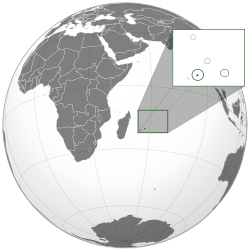
มอริเชียส (อังกฤษ: Mauritius; ฝรั่งเศส: Maurice, [mɔʁis, moʁis] (![]() ฟังเสียง); ครีโอลมอริเชียส: Moris [moʁis]) มีชื่ออย่างเป็นทางการว่า สาธารณรัฐมอริเชียส (อังกฤษ: Republic of Mauritius; ฝรั่งเศส: République de Maurice; ครีโอลมอริเชียส: Repiblik Moris) คือประเทศที่เป็นเกาะนอกชายฝั่งแอฟริกาในมหาสมุทรอินเดียตะวันตกเฉียงใต้ ตั้งอยู่ทางตะวันออกของมาดากัสการ์ ประมาณ 900 กิโลเมตร (560 ไมล์) และทางตะวันตกเฉียงใต้ของอินเดียประมาณ 3,943 กิโลเมตร (2,450 ไมล์) นอกจากตัวเกาะมอริเชียสแล้ว สาธารณรัฐมอริเชียสประกอบด้วย ใช้ภาษาฝรั่งเศสเกาะเซนต์แบรนดอน เกาะร็อดริก และหมู่เกาะอากาเลกา มอริเชียสเป็นส่วนหนึ่งของหมู่เกาะแมสคารีน มีเกาะเรอูว์นียงของฝรั่งเศส ตั้งอยู่ห่างจากมอริเชียสไปทางตะวันตกเฉียงใต้ประมาณ 200 กิโลเมตร (125 ไมล์)
ฟังเสียง); ครีโอลมอริเชียส: Moris [moʁis]) มีชื่ออย่างเป็นทางการว่า สาธารณรัฐมอริเชียส (อังกฤษ: Republic of Mauritius; ฝรั่งเศส: République de Maurice; ครีโอลมอริเชียส: Repiblik Moris) คือประเทศที่เป็นเกาะนอกชายฝั่งแอฟริกาในมหาสมุทรอินเดียตะวันตกเฉียงใต้ ตั้งอยู่ทางตะวันออกของมาดากัสการ์ ประมาณ 900 กิโลเมตร (560 ไมล์) และทางตะวันตกเฉียงใต้ของอินเดียประมาณ 3,943 กิโลเมตร (2,450 ไมล์) นอกจากตัวเกาะมอริเชียสแล้ว สาธารณรัฐมอริเชียสประกอบด้วย ใช้ภาษาฝรั่งเศสเกาะเซนต์แบรนดอน เกาะร็อดริก และหมู่เกาะอากาเลกา มอริเชียสเป็นส่วนหนึ่งของหมู่เกาะแมสคารีน มีเกาะเรอูว์นียงของฝรั่งเศส ตั้งอยู่ห่างจากมอริเชียสไปทางตะวันตกเฉียงใต้ประมาณ 200 กิโลเมตร (125 ไมล์)
สาธารณรัฐมอริเชียส
| |
|---|---|
 หมู่เกาะของสาธารณรัฐมอริเชียส (ไม่รวมกลุ่มเกาะชากอสและเกาะตรอมแล็ง) | |
 หมู่เกาะของสาธารณรัฐมอริเชียสในอักษรสีดำ; รวมกลุ่มเกาะชากอสและเกาะตรอมแล็งที่อ้างสิทธิโดยมอริเชียส | |
| เมืองหลวง และเมืองใหญ่สุด | พอร์ตลูอิส 20°12′S 57°30′E / 20.2°S 57.5°E |
| ภาษาราชการ | ไม่มี (โดยนิตินัย) อังกฤษ (โดยพฤตินัย) ฝรั่งเศส (โดยพฤตินัย)[Note 1] |
| กลุ่มชาติพันธุ์ | |
| ศาสนา (สำมะโน ค.ศ. 2011)[3] | |
| การปกครอง | รัฐเดี่ยว สาธารณรัฐระบบรัฐสภา |
| Prithvirajsing Roopun | |
| Eddy Boissezon | |
| Pravind Jugnauth | |
| Sooroojdev Phokeer | |
| สภานิติบัญญัติ | รัฐสภา |
| เอกราช | |
| 12 มีนาคม ค.ศ. 1968 | |
• สาธารณรัฐ | 12 มีนาคม ค.ศ. 1992 |
| พื้นที่ | |
• รวม | 2,040 ตารางกิโลเมตร (790 ตารางไมล์) (อันดับที่ 169) |
| 0.07 | |
| ประชากร | |
• 2019 ประมาณ | 1,265,475[4] (อันดับที่ 158) |
• สำมะโนประชากร 2011 | 1,237,091[5] |
| 618.24 ต่อตารางกิโลเมตร (1,601.2 ต่อตารางไมล์) (อันดับที่ 21) | |
| จีดีพี (อำนาจซื้อ) | 2019 (ประมาณ) |
• รวม | 31.705 พันล้านดอลลาร์สหรัฐ[6] (อันดับที่ 133) |
• ต่อหัว | 25,029 ดอลลาร์สหรัฐ[6] (อันดับที่ 61) |
| จีดีพี (ราคาตลาด) | 2019 (ประมาณ) |
• รวม | 14.812 พันล้านดอลลาร์สหรัฐ[6] (อันดับที่ 129) |
• ต่อหัว | 11,693 ดอลลาร์สหรัฐ[6] (อันดับที่ 64) |
| จีนี (2017) | 36.8[7] ปานกลาง |
| เอชดีไอ (2020) | สูงมาก · อันดับที่ 66 |
| สกุลเงิน | รูปี (MUR) |
| เขตเวลา | UTC+4 (เวลามอริเชียส) |
| รูปแบบวันที่ | วว/ดด/ปปปป (ค.ศ.) |
| ขับรถด้าน | ซ้ายมือ |
| รหัสโทรศัพท์ | +230 |
| โดเมนบนสุด | .mu |
ภูมิศาสตร์
แก้ประเทศมอริเชียสมีพื้นที่ทั้งหมดประมาณ 2,040 ตารางกิโลเมตรใหญ่เป็นอันดับ 170 ของโลก ประเทศมอริเชียสประกอบด้วยเกาะมอริเชียสและเกาะชั้นนอกอีกหลายเกาะอาทิเกาะร็อดริกเป็นเกาะที่ใหญ่เป็นอันดับ 2 ของประเทศมีพื้นที่ประมาณ 108 ตารางกิโลเมตรห่างจากเกาะมอริเชียสไปทางตะวันออก 560 กิโลเมตร เกาะแฝดอากาเลกามีพื้นที่ประมาณ 26 ตารางกิโลเมตรและห่างจากเกาะหลักไปทางเหนือ 1000 กิโลเมตร เซนต์แบรนดอนคือกลุ่มเกาะที่ประกอบด้วยดอนทรายใต้น้ำและเกาะเล็กใช้เป็นที่ตั้งการประมงของบริษัท ราฟาเอลฟิชเชอร์ จำกัด (Raphael Fishing Company Limited)[9][10] ตั้งอยู่ห่างจากเกาะหลักไปทางตะวันออกเฉียงเหนือ 430 ตารางกิโลเมตร เขตเศรษฐกิจจำเพาะของประเทศมอริเชียสนั้นครอบคลุมพื้นที่ในมหาสมุทรอินเดียกว่า 2.3 ล้านตารางกิโลเมตรและมีพื้นจัดการร่วมกับประเทศเซเชลส์อีกประมาณ 400,000 ตารางกิโลเมตร[11][12][13]
หมายเหตุ
แก้- ↑ รัฐธรรมนูญมอริเชียสไม่ได้ระบุภาษาทางการ แต่ระบุเฉพาะว่าภาษาทางการในรัฐสภาคือภาษาอังกฤษ; อย่างไรก็ตาม สมาชิกในรัฐสภาสามารถพูดแก่ประธานสภาในภาษาฝรั่งเศสได้
- ↑ Language most often spoken at home, as per 2011 Census.
อ้างอิง
แก้- ↑ "Government Information Service – Coat of Arms". www.govmu.org. คลังข้อมูลเก่าเก็บจากแหล่งเดิมเมื่อ 2020-06-12. สืบค้นเมื่อ 29 July 2019.
- ↑ "Mauritius – the World Factbook". 27 December 2021.
- ↑ "Archived copy" (PDF). คลังข้อมูลเก่าเก็บจากแหล่งเดิม (PDF)เมื่อ 2014-05-14. สืบค้นเมื่อ 2015-04-26.
{{cite web}}: CS1 maint: archived copy as title (ลิงก์) - ↑ "Population and Vital Statistics – Year 2019". Statistics Mauritius. March 2020. สืบค้นเมื่อ 6 May 2020.
- ↑ 5.0 5.1 Statistics Mauritius. "2011 Population Census – Main Results" (PDF). Government Portal of Mauritius. สืบค้นเมื่อ 11 November 2017.
{{cite journal}}: Cite journal ต้องการ|journal=(help) - ↑ 6.0 6.1 6.2 6.3 "World Economic Outlook Database, April 2019". IMF.org. International Monetary Fund. สืบค้นเมื่อ 8 June 2019.
- ↑ "GINI index (World Bank estimate) – Mauritius". data.worldbank.org. World Bank. สืบค้นเมื่อ 1 July 2020.
- ↑ Human Development Report 2020 The Next Frontier: Human Development and the Anthropocene (PDF). United Nations Development Programme. 15 December 2020. pp. 343–346. ISBN 978-92-1-126442-5. สืบค้นเมื่อ 16 December 2020.
- ↑ "Mauritius: The Raphael Fishing Company Limited: Privy Council Decisions [2008] UKPC 43 (30 July 2008)". SAFLII. สืบค้นเมื่อ 30 July 2008.
- ↑ "The territory of Mauritius". Government Portal of Mauritius. คลังข้อมูลเก่าเก็บจากแหล่งเดิมเมื่อ 2023-03-27. สืบค้นเมื่อ 22 January 2015.
- ↑ "MAURITIUS: PROMOTING THE DEVELOPMENT OF AN OCEAN ECONOMY". Intercontinental Trust. คลังข้อมูลเก่าเก็บจากแหล่งเดิม (PDF)เมื่อ 2017-10-10. สืบค้นเมื่อ 22 January 2015.
- ↑ "National Coast Guard" (PDF). Government Portal of Mauritius. สืบค้นเมื่อ 22 January 2015.
- ↑ "Commission on the Limits of the Continental Shelf (CLCS) Outer limits of the continental shelf beyond 200 nautical miles from the baselines:Submissions to the Commission: Joint submission by the Republic of Mauritius and the Republic of Seychelles". United Nations. สืบค้นเมื่อ 22 January 2015.
บรรณานุกรม
แก้- This article incorporates public domain text from the websites of the Government Portal of Mauritius เก็บถาวร 2018-10-22 ที่ เวย์แบ็กแมชชีน, the United States Department of State, the U.S. Library of Congress, and the CIA World Factbook.
- Macdonald, Fiona; และคณะ. "Mauritius". Peoples of Africa. pp. 340–341.
อ่านเพิ่ม
แก้- Bahadur, Gaiutra (2014). Coolie Woman: The Odyssey of Indenture. The University of Chicago. ISBN 978-0-226-21138-1.
- Moree, Perry J. (1998). A Concise History of Dutch Mauritius, 1598–1710: A Fruitful and Healthy Land. Routledge.
- Vink, Markus (2003). "'The World's Oldest Trade': Dutch Slavery and Slave Trade in the Indian Ocean in the Seventeenth Century". Journal of World History. 14 (2): 131–177. doi:10.1353/jwh.2003.0026. S2CID 145450338.
วรรณกรรม
แก้- J.M.G. Le Clézio, La quarantaine, Gallimard, 1997ISBN 9782070402106
- Nathacha Appanah, Les rochers de poudre d'or, Gallimard, 2006
- Geneviève Dormann, Le bal du dodo, Albin Michel, 2000 ISBN 9782226036568
- Shenaz Patel, Le silence des Chagos, éditions de l'Olivier, 2005 ISBN 9782879294544
แหล่งข้อมูลอื่น
แก้อ้างอิง
- Mauritius. The World Factbook. Central Intelligence Agency.
- Mauritius entry at Encyclopædia Britannica
- Mauritius at UCB Libraries GovPubs
- ประเทศมอริเชียส ที่เว็บไซต์ Curlie
- Country Profile from BBC News
- Key Development Forecasts for Mauritius from International Futures
รัฐบาล
- Mauritius Government portal เก็บถาวร 2018-10-22 ที่ เวย์แบ็กแมชชีน
- Statistics Mauritius
- Board of Investment
ภูมิศาสตร์
- Wikimedia Atlas of Mauritius
- ดูข้อมูลทางภูมิศาสตร์ที่เกี่ยวข้องกับ ประเทศมอริเชียส ที่โอเพินสตรีตแมป
- WikiSatellite view of Mauritius at WikiMapia

