ที่ราบสูงทิเบต
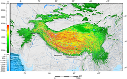
ที่ราบสูงทิเบต (อังกฤษ: Tibetan Plateau; ทิเบต: བོད་ས་མཐོ།, ไวลี: bod sa mtho) มีอีกชื่อว่า ที่ราบสูงชิงไห่–ทิเบต[1] ที่ราบสูงชิง–ซ่าง[2] (จีน: 青藏高原; พินอิน: Qīng–Zàng Gāoyuán) หรือในประเทศอินเดียว่า ที่ราบสูงหิมาลัย[3][4] เป็นที่ราบสูงกว้างใหญ่ในเอเชียกลาง[5][6][7][8] และเอเชียตะวันออก[9][10][11][12] ในจีนตะวันตกกินพื้นที่เขตปกครองตนเองทิเบตส่วนใหญ่ มณฑลชิงไห่ส่วนใหญ่ มณฑลยูนนานตะวันตกเฉียงเหนือ มณฑลเสฉวนฝั่งตะวันตก และมณฑลกานซู่ตอนใต้ ส่วนแคว้นอินเดียกินพื้นที่ในลาดักกับLahaul และ Spiti (หิมาจัลประเทศ) และประเทศภูฏาน ที่ราบสูงนี้กินพื้นที่จากเหนือลงใต้ประมาณ 1,000 กิโลเมตร (620 ไมล์) และจากตะวันออกไปตะวันตก 2,500 กิโลเมตร (1,600 ไมล์) ด้วยพื้นที่ 2,500,000 ตารางกิโลเมตร (970,000 ตารางไมล์) ทำให้เป็นที่ราบสูงที่ใหญ่ที่สุดและสูงที่สุดในโลกที่อยู่เหนือระดับน้ำทะเล (ประมาณห้าเท่าของประเทศฝรั่งเศสแผ่นดินใหญ่)[13] ซึ่งด้วยความสูงเฉลี่ยมากกว่า 4,500 เมตร (14,800 ฟุต) และล้อมรอบด้วยเทือกเขาที่มียอดเขาสองแห่งคือยอดเขาเอเวอเรสต์และเค2 ทำให้ที่ราบสูงทิเบตมักถูกเรียกเป็น "หลังคาโลก"
| ที่ราบสูงทิเบต | |
|---|---|
| 青藏高原 (Qīng–Zàng Gāoyuán, ที่ราบสูงชิงไห่–ทิเบต) | |
 ที่ราบสูงทิเบตตั้งอยู่ระหว่างเทือกเขาหิมาลัยทางตอนใต้กับทะเลทรายทากลามากันทานตอนเหนือ (ภาพประกอบ) | |
| ข้อมูลเชิงขนาด | |
| ยาว | 2,500 กม. (1,553 ไมล์) |
| กว้าง | 1,000 กม. (621 ไมล์) |
| พื้นที่ | Invalid unit |
| ข้อมูลทางภูมิศาสตร์ | |
| ที่ตั้ง | จีน (ทิเบต, มณฑลชิงไห่, มณฑลเสฉวนตะวันตก, มณฑลยูนนานตอนเหนือ, ซินเจียงตอนใต้, มณฑลกานซู่ตะวันตก) อินเดีย (ลาดัก, Lahaul และ Spiti) ปากีสถาน (กิลกิต-บัลติสถาน) เนปาล (เนปาลเหนือ) ภูฏาน ทาจิกิสถาน (ทาจิกิสถานตะวันออก) คีร์กีซสถาน (คีร์กีซสถานใต้) |
| พิกัดเทือกเขา | 33°N 88°E / 33°N 88°E |
ที่ราบสูงทิเบตเป็นต้นน้ำของที่ราบลุ่มแม่น้ำส่วนใหญ่ในบริเวณล้อมรอบ บริเวณนี้มีธารน้ำแข็งหมื่นกว่าแห่งและลักษณะทางภูมิศาสตร์กับระบบนิเวศอื่น ๆ ที่ทำหน้าที่เป็น "หอเก็บน้ำ" และรักษาน้ำท่า ทำให้บางครั้งมีการเรียกบริเวณนี้ว่า ขั้วโลกที่สาม เพราะมีทุ่งน้ำแข็งที่มีน้ำจืดสำรองขนาดใหญ่นอกเขตขั้วโลก ผลกระทบจากภาวะโลกร้อนในที่ราบสูงทิเบตทำให้มีความสนใจในทางวิทยาศาสตร์อย่างเข้มข้น[14][15][16][17]
อ้างอิง แก้
อ้างอิง แก้
- ↑ Wang, Zhaoyin; Li, Zhiwei; Xu, Mengzhen; Yu, Guoan (30 March 2016). River Morphodynamics and Stream Ecology of the Qinghai-Tibet Plateau. CRC Press.
- ↑ Jones, J.A.; Liu, Changming; Woo, Ming-Ko; Kung, Hsiang-Te (6 December 2012). Regional Hydrological Response to Climate Change. Springer Science & Business Media. p. 360.
- ↑ "हिमालयी क्षेत्र में जीवन यापन पर रिसर्च करेंगे अमेरिका और भारत".
- ↑ "In Little Tibet, a story of how displaced people rebuilt life in a distant land". 18 February 2020.
- ↑ Illustrated Atlas of the World (1986) Rand McNally & Company. ISBN 0-528-83190-9 pp. 164–65
- ↑ Atlas of World History (1998 ) HarperCollins. ISBN 0-7230-1025-0 p. 39
- ↑ "The Tibetan Empire in Central Asia (Christopher Beckwith)". สืบค้นเมื่อ 19 February 2009.
- ↑ Hopkirk 1983, p. 1
- ↑ Peregrine, Peter Neal & Melvin Ember, etc. (2001). Encyclopedia of Prehistory: East Asia and Oceania, Volume 3. Springer. p. 32. ISBN 978-0-306-46257-3.
- ↑ Morris, Neil (2007). North and East Asia. Heinemann-Raintree Library. p. 11. ISBN 978-1-4034-9898-4.
- ↑ Webb, Andrew Alexander Gordon (2007). Contractional and Extensional Tectonics During the India-Asia Collision. ProQuest LLC. p. 137. ISBN 978-0-549-50627-0.
- ↑ Marston, Sallie A. and Paul L. Knox, Diana M. Liverman (2002). World regions in global context: peoples, places, and environments. Prentice Hall. p. 430. ISBN 978-0-13-022484-2.
{{cite book}}: CS1 maint: uses authors parameter (ลิงก์) - ↑ "Natural World: Deserts". National Geographic. คลังข้อมูลเก่าเก็บจากแหล่งเดิมเมื่อ 12 January 2006.
- ↑ Leslie Hook (30 August 2013). "Tibet: life on the climate front line". Financial Times. สืบค้นเมื่อ 1 September 2013.
- ↑ Liu, Xiaodong; Chen (2000). "Climatic warming in the Tibetan Plateau during recent decades". International Journal of Climatology. 20 (14): 1729–1742. Bibcode:2000IJCli..20.1729L. CiteSeerX 10.1.1.669.5900. doi:10.1002/1097-0088(20001130)20:14<1729::aid-joc556>3.0.co;2-y – โดยทาง Academia.edu.
- ↑ Ni, Jian (2000). "A Simulation of Biomes on the Tibetan Plateau and Their Responses to Global Climate Change". Mountain Research and Development. 20 (1): 80–89. doi:10.1659/0276-4741(2000)020[0080:ASOBOT]2.0.CO;2.
- ↑ Cheng, Guodong; Wu (8 June 2007). "Responses of permafrost to climate change and their environmental significance, Qinghai-Tibet Plateau". Journal of Geophysical Research. 112 (F2): F02S03. Bibcode:2007JGRF..112.2S03C. doi:10.1029/2006JF000631. S2CID 14450823.
ข้อมูล แก้
- Hopkirk, Peter (1983). Trespassers on the Roof of the World: The Secret Exploration of Tibet. J. P. Tarcher. ISBN 978-0-87477-257-9.
- Brantingham, P. J. & Xing, G. (2006). "Peopling of the northern Tibetan Plateau". World Archaeology. 38 (3): 387–414. doi:10.1080/00438240600813301. S2CID 13534630.
แหล่งข้อมูลอื่น แก้
- ON THINNER ICE 如履薄冰 (by GRIP, Asia Society and MediaStorm)
- The Third Pole: Understanding Asia's Water Crisis
- The End of Earth's Summer
- Long Rivers and Distant Sources
- "Roof of the Earth" Offers Clues About How Our Planet Was Shaped เก็บถาวร 2012-10-31 ที่ เวย์แบ็กแมชชีน
- Plateau Perspectives (international NGO)
- Leaf morphology and the timing of the rise of the Tibetan Plateau
- "Weather in the eastern Chang Tang". คลังข้อมูลเก่าเก็บจากแหล่งเดิมเมื่อ 19 March 2006. สืบค้นเมื่อ 9 May 2006.
{{cite web}}: CS1 maint: bot: original URL status unknown (ลิงก์) - Protected areas of the Tibetan Plateau region
- "North Tibetan Plateau-Kunlun Mountains alpine desert". Terrestrial Ecoregions. World Wildlife Fund.
- Photos of Tibetan nomads
- "Roof of the Earth" Offers Clues About How Our Planet Was Shaped
- Contemporary lifestyle and language learning center from Tibet lhasa, the official language of Tibetan. podcast.
- Tibetan History-The true history of any region cannot be fully understood without knowing the basic characteristics of a region and of its inhabitants
