ผู้ใช้:EZBELLA/กระบะทราย6
| กระบะทราย1 | กระบะทราย2 | กระบะทราย3 | กระบะทราย4 | กระบะทราย5 | กระบะทราย6 | กระบะทราย7 |
 | นี่คือหน้าทดลองเขียนของ EZBELLA หน้าทดลองเขียนเป็นหน้าย่อยของหน้าผู้ใช้ ซึ่งผู้ใช้มีไว้ทดลองเขียนหรือไว้พัฒนาหน้าต่าง ๆ แต่นี่ไม่ใช่หน้าบทความสารานุกรม ทดลองเขียนได้ที่นี่ หน้าทดลองเขียนอื่น ๆ: หน้าทดลองเขียนหลัก |

นี่คือ รายการภูเขาที่สูงที่สุดในระบบสุริยะ มีการวัดคงามสูงของยอดเขาที่สูงที่สุดและยอดเขาสำคัญ ๆ ยอดเขาแต่ละลูกมีลักษณะการเกิดที่ต่างกันไป
ภูเขาไฟโอลิมปัส ภูเขาไฟรูปโล่บนดาวอังคารสูง 21.9 ก.ม. นั้นเป็นภูเขาที่สูงที่สุดบนดาวเคราะห์ดวงอื่น และยังถูกเชื่อว่าเป็นภูเขาที่สูงทีสุดในระบบสุริยะเป็นเวลากว่า 40 ปีหลังจากการค้นพบใน พ.ศ. 2514 อย่างไรก็ตามใน พ.ศ. 2554 มีรายงานการค้นพบยอดเขากลางแอ่งชื่อว่ารีอาซิลเวียบนดาวเคราะห์น้อย 4 เวสตาและระบุได้ว่ายอดเขานี้มีความสูงใกล้เคียงกัน[หมายเหตุ 1]
รายชื่อ
แก้ความสูงในตารางนี้จะวัดจากฐานถึงยอด ไม่ได้วัดตามความสูงเหนือระดับน้ำทะเลเพราะดาวดวงอื่นไม่มีทะเล
| ดาว | ยอดเขาสูงสุด | ความสูงจากฐานถึงยอด | % ของรัศมี[หมายเหตุ 2] | รูปแบบการเกิด | หมายเหตุ |
|---|---|---|---|---|---|
| ดาวพุธ | ภูเขาแคลอริส | 3 กิโลเมตร (1.9 ไมล์)[1][2] | 0.12 | แอ่งปะทะ[3] | ก่อตัวขึ้นจากที่ราบต่ำแคลอริส |
| ดาวศุกร์ | สคาร์ดิมอนส์ | 6.4 กิโลเมตร (4.0 ไมล์) (ค่าประมาณ)[4] | 0.11 | การก่อเทือกเขา[5] | มีความสว่างและลาดชั้นจากโลหะที่เรียกว่าหิมะดาวศุกร์, ซึ่งคาดว่าน่าจะเป็นกาลีนา[6] |
| มัทมอนส์ | 4.9 กิโลเมตร (3.0 ไมล์) (ค่าประมาณ)[7] | 0.081 | ภูเขาไฟ[8] | ภูเขาไฟที่สูงที่สุดบนดาวศุกร์ | |
| โลก | เมานาเคอา และ เมานาโลอา | 10.2 กิโลเมตร (6.3 ไมล์)[9] | 0.16 | ภูเขาไฟ | ยอดโพล่พ้นระดับน้ำทะเลประมาณ 4.2 กิโลเมตร (2.6 ไมล์) |
| ฮาเลอาคาลา | 9.1 กิโลเมตร (5.7 ไมล์)[10] | 0.14 | ภูเขาไฟ | ยอดโพล่พ้นระดับน้ำทะเลประมาณ 3.1 กม. [10] | |
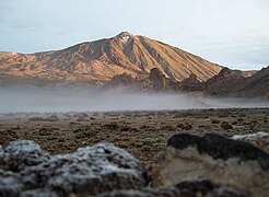
| เอล เตเด่ | 7.5 กิโลเมตร (4.7 ไมล์)[11] | 0.12 | ภูเขาไฟ | ยอดโพล่พ้นระดับน้ำทะเลประมาณ 3.7 กม.[11] | |
| เดนาลี | 5.3 ถึง 5.9 กิโลเมตร (3.3 ถึง 3.7 ไมล์)[12] | 0.093 | การก่อเทือกเขา | ภูเขาที่สูงที่สุดบนแผ่นดินวัดจากตีนเขาถึงยอด[13][หมายเหตุ 3] | |
| เอเวอเรสต์ | 3.6 ถึง 4.6 กิโลเมตร (2.2 ถึง 2.9 ไมล์)[14] | 0.072 | การก่อเทือกเขา | ทิศเหนือสุง 4.6 กม. ทิศใต้สูง 3.6 กม.[หมายเหตุ 4] ถูกแสดงในรายชื่อนี้เพราะอยู่สูงจากทะเลปานกลาง (8.8 กม.) | |
| ดวงจันทร์ | มอนส์เฮยเคินส์ | 5.5 กิโลเมตร (3.4 ไมล์)[15][16] | 0.32 | แอ่งปะทะ | ก่อตัวจากทะเลแห่งฝน |
| มอนส์ฮัดลีย์ | 4.5 กิโลเมตร (2.8 ไมล์)[15][16] | 0.26 | แอ่งปะทะ | ก่อตัวจากทะเลแห่งฝน | |
| มอนส์รัมเกอร์ | 1.1 กิโลเมตร (0.68 ไมล์)[17] | 0.063 | ภูเขาไฟ | ภูเขาไฟที่ใหญ่ที่สุดบนดวงจันทร์[17] | |
| ดาวอังคาร | โอลิมปัสมอนส์ | 21.9 กิโลเมตร (14 ไมล์)[18][19] | 0.65 | ภูเขาไฟ | สูงจากที่ราบทางตอนเหนือประมาณ 26 กม. [20] แอ่งยุบปากปล่องบนยอดมีพื้นที่ 60 x 80 ตารางกิโลเมตร ลึก 3.2 กม.[19] บริเวณขอบของภูเขาไฟมีความสูง 8 กม.[21] |
| อัสเตรอัสมอนส์ | 14.9 กิโลเมตร (9.3 ไมล์)[18] | 0.44 | ภูเขาไฟ | สูงที่สุดในกลุ่มภูเขาไฟตาร์ซิส มอนเตส | |
| อีลิเซียมมอนส์ | 12.6 กิโลเมตร (7.8 ไมล์)[18] | 0.37 | ภูเขาไฟ | ภูเขาไฟที่สูงที่สุดใน อีลิเซียม | |
| อาร์เซียมอนส์ | 11.7 กิโลเมตร (7.3 ไมล์)[18] | 0.35 | ภูเขาไฟ | แอ่งยุบปากปล่องบนยอดกว้าง 108 ถึง 138 กิโลเมตร (67 ถึง 86 ไมล์)[18] | |
| เพโวนิสมอนส์ | 8.4 กิโลเมตร (5.2 ไมล์)[18] | 0.25 | ภูเขาไฟ | แอ่งยุบปากปล่องบนยอดลึก 4.8 กิโลเมตร (3.0 ไมล์)[18] | |
| เอ็นเซริสมอนส์ | 6.2 กิโลเมตร (3.9 ไมล์)[22] | 0.18 | แอ่งปะทะ | ยอดที่สูงที่สุดที่ไม่ใช้ภูเขาไฟ เกิดจากหุบอุกกาบาตเฮลัส | |
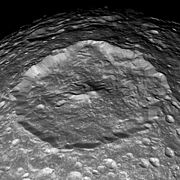
| อีโอลิสมอนส์ | 4.5 ถึง 5.5 กิโลเมตร (2.8 ถึง 3.4 ไมล์)[23][หมายเหตุ 5] | 0.16 | การทับทมและการกร่อน[หมายเหตุ 6] | รถแลนด์โรเวอร์ส่งข้อมูลมาใน ค.ศ. 2014 ว่า[27]เกิดจากการทับทมใน หุบอุตกาบาตกาเล่[28] | |
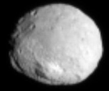
| 4 เวสตา | รีอาซิลเวีย | 22 กิโลเมตร (14 ไมล์)[29][30] | 8.4 | แอ่งปะทะ | หุบอุกกาบาตมีความกว้างกว่า 200 กิโลเมตร (120 ไมล์) ดูเพิ่ม:รายการหุบอุกกาบาตที่ใหญ่สุดในระบบสุริยะ |
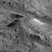
| ซีรีส | อฮูน่ามอนส์ | 4 กิโลเมตร (2.5 ไมล์)[31] | 0.85 | ภูเขาไฟน้ำแข็ง[32] | ยอดมีความราบเรียบและสูง ~5 กม. อีกด้านหนึงของโดมติดกับหุบอุกกาบาตขนาดใหญ่ |
| ไอโอ | บูร์เซาเล มอนเตส "ใต้"[33] | 17.5 ถึง 18.2 กิโลเมตร (10.9 ถึง 11.3 ไมล์)[34] | 1.0 | การก่อเทือกเขา | มีหน้าผาชั้นประมาณ 15 กิโลเมตร (9 ไมล์) บริเวณขอบทางทิศตะวันออกเฉียงใต้[35] |
| สันเขาไอโอเนียนมอนส์ตะวันออก (Ionian Mons east ridge) |
12.7 กิโลเมตร (7.9 ไมล์) (ค่าประมาณ)[35][36] | 0.70 | การก่อเทือกเขา | ||
| อีวเบียร์ มอนเตส | 10.3 ถึง 13.4 กิโลเมตร (6.4 ถึง 8.3 ไมล์)[37] | 0.74 | การก่อเทือกเขา | มีดินถล่มบริเวณทิศตะวันออกเฉียงเหนือ โดยมีเศษซากขนาด 25,000 กม.3[38][หมายเหตุ 7] | |
| ยังไม่ได้ตั้งชื่อ (245° W, 30° S) | 2.5 กิโลเมตร (1.6 ไมล์) (ค่าประมาณ)[39][40] | 0.14 | ภูเขาไฟ | ภูเขาไฟที่สูงที่สุดลูกหนึ่งของไอโอ มีลักษณะเป็นทรงกรวยที่ผิดปกติ[40][หมายเหตุ 8] | |
| ไมมัส | เฮอร์เชล เซนทแร็ลพีค | 7 กิโลเมตร (4 ไมล์) (ค่าประมาณ)[42] | 3.5 | แอ่งปะทะ | ดูเพิ่ม: รายการหุบอุกกาบาตที่ใหญ่สุดในระบบสุริยะ |
| ไดโอนี | จูเนย์คิวลัม ดอซาร์ | 1.5 กิโลเมตร (0.9 ไมล์)[43] | 0.27 | การก่อเทือกเขา[หมายเหตุ 9] | |
| ไททัน | มิทตริม มอนเตส | ≤ 3.3 กิโลเมตร (2.1 ไมล์)[46] | 0.13 | การก่อเทือกเขา[46] | อาจเกิดจากการหดตัวของดาว[47] |
| ดูม มอนส์ | 1.45 กิโลเมตร (0.90 ไมล์)[48] | 0.056 | ภูเขาไฟน้ำแข็ง[48] | ||
| ไอแอพิตัส | เทือกเข้าตามแนวศูนย์สูตร | 20 กิโลเมตร (12 ไมล์) (ค่าประมาณ)[49] | 2.7 | ไม่แน่ชัด[หมายเหตุ 10] | ยอดเขาตามแนวเทือกเขายังไม่ได้วัด |
| โอเบอร็อน | ยังไม่มีชื่อ ("ภูเขาลิม") | 11 กิโลเมตร (7 ไมล์) (ค่าประมาณ)[42] | 1.4 | แอ่งปะทะ (?) | ระบุว่ามีความสูล 6 กม. หลังจาก วอยเอจเจอร์ 2 บินผ่าน[53] |
| พลูโต | พิคคาร์ด มอนส์[หมายเหตุ 11][54][55] | ~5.6 กิโลเมตร (3.5 ไมล์)[56] | 0.47 | ภูเขาไฟน้ำแข็ง (?) | ~220 กม. ตามแนวขวาง[56] |
| ไวรท์ มอนส์{[หมายเหตุ 11][54][55] | ~4.0 กิโลเมตร (2.5 ไมล์)[54] | 0.34 | ภูเขาไฟน้ำแข็ง (?) | ~160 กม. ตามแนวขวาง[54] ยอดเขามีการยุบตัวตามแนวขวาง ~56 กม.[57] | |
| เท็นซิง มอนเตส[58] | ≤ 3.5 กิโลเมตร (2.2 ไมล์)[59] | 0.30 | ธรณีแปรสัณฐาน[59] (?) | ก่อตัวจากน้ำที่กลายเป็นน้ำแข็ง;[59] ตั้งชื่อตามเทนซิง นอร์เก[60] | |
| แครอน | บัตเลอร์ มอนส์[61] | ≥ 4.5 กิโลเมตร (2.8 ไมล์)[61] | 0.74 | ธรณีแปรสัณฐาน (?) | |
| โดโรธี เซนทแร็ลพีค[61] | ~4.0 กิโลเมตร (2.5 ไมล์)[61] | 0.66 | แอ่งปะทะ | แอ่งกระแทกบริเวณขั่วเหนือ เป็นแอ่งกระแทกที่ใหญ่ที่สุดของแครอน มีขนาด ∼240 กม. ตามแนวขวาง และลึก 6 กม.[61] |
ระเบียงภาพ
แก้The following images are shown in order of decreasing base-to-peak height.
-
-
 Olympus Mons on Mars as viewed from Viking 1 in 1978
 -
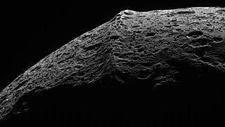 Cassini image of Iapetus's equatorial ridge
 -
 Voyager 1 photo of Io's highest peak, Boösaule Montes "South"
 -

-
 Io's Euboea Montes (below top left), Haemus Montes (lower right); north is left
 -

-
-
 Cassini photo of Herschel crater on Mimas and its central peak
 -

-

-
![Aeolis Mons ("Mount Sharp"), Mars (as viewed by the rover Curiosity on 6 August 2012).[หมายเหตุ 12]](//upload.wikimedia.org/wikipedia/commons/thumb/6/65/673885main_PIA15986-full_full.jpg/180px-673885main_PIA15986-full_full.jpg)
-
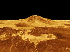 Maat Mons, Venus (radar imaging plus altimetry, 10x vertical exaggeration)
 -
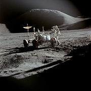 The Moon's Mons Hadley, near the Apollo 15 landing site (1971)
 -
-
-

-
 New Horizons image of the enigmatic Norgay Montes of Pluto
 -

-
 Radar-generated view of Titan's cryovolcanic Doom Mons and Sotra Patera (10x vertical stretch)


![Aeolis Mons ("Mount Sharp"), Mars (as viewed by the rover Curiosity on 6 August 2012).[หมายเหตุ 12]](/wiki/%E0%B9%84%E0%B8%9F%E0%B8%A5%E0%B9%8C:673885main_PIA15986-full_full.jpg)


หมายเหตุ
แก้- ↑ อย่างไรก็ตามโอลิมปัสเป็นภูเขาสูงที่มีฐานกว้างมาก ความกว้างของฐานใกล้เคียงกับเส้นผ่านศูนย์กลางของ 4 เวสตา
- ↑ 100 x สัดส่วนความสูง / รัศมีของดาว
- ↑ ในหน้าที่ 20 ของหลังสือ Helman (2005) ระบุว่า: "ฐานของยอดเขาแมกคินลีย์นั้น เป้นฐานเขาที่ใหญ่ที่สุดของภูเขาที่อยู่เหนือระดับน้ำทะเล โดยมันมีความกว้างที่ 18,000 ฟุต (5,500 เมตร)"
- ↑ ยอดเขาอยู่สูงจากระดับน้ำทะเลประมาณ 8.8 กิโลเมตร (5.5 ไมล์) และสูงจากที่ราบก้นสมุทรประมาณ 13 กิโลเมตร (8.1 ไมล์)
- ↑ สูงประมาณ 5.25 กิโลเมตร (3.26 ไมล์) เมื่อมองจากจุดลองจอด คิวริออซิตี[24]
- ↑ A crater central peak may sit below the mound of sediment. If that sediment was deposited while the crater was flooded, the crater may have once been entirely filled before erosional processes gained the upper hand.[23] However, if the deposition was due to katabatic winds, as suggested by reported 3 degree radial slopes of the mound's layers, the role of erosion would have been to place an upper limit on the mound's growth.[25][26]
- ↑ Among the Solar System's largest[38]
- ↑ Some of Io's paterae are surrounded by radial patterns of lava flows, indicating they are on a topographic high point, making them shield volcanoes. Most of these volcanoes exhibit relief of less than 1 km. A few have more relief; Ruwa Patera rises 2.5 to 3 km over its 300 km width. However, its slopes are only on the order of a degree.[41] A handful of Io's smaller shield volcanoes have steeper, conical profiles; the example listed is 60 km across and has slopes averaging 4° and reaching 6-7° approaching the small summit depression.[41]
- ↑ Was apparently formed via contraction.[44][45]
- ↑ Hypotheses of origin include crustal readjustment associated with a decrease in oblateness due to tidal locking,[50][51] and deposition of deorbiting material from a former ring around the moon.[52]
- ↑ 11.0 11.1 Name not yet approved by the IAU
- ↑ A linearized wide-angle hazcam image that makes the mountain look steeper than it actually is. The highest peak is not visible in this view.
อ้างอิง
แก้- ↑ "Surface". MESSENGER web site. Johns Hopkins University/Applied Physics Lab. สืบค้นเมื่อ 4 April 2012.
- ↑ Oberst, J.; Preusker, F.; Phillips, R. J.; Watters, T. R.; Head, J. W.; Zuber, M. T.; Solomon, S. C. (2010). "The morphology of Mercury's Caloris basin as seen in MESSENGER stereo topographic models". Icarus. 209 (1): 230–238. Bibcode:2010Icar..209..230O. doi:10.1016/j.icarus.2010.03.009. ISSN 0019-1035.
- ↑ Fassett, C. I.; Head, J. W.; Blewett, D. T.; Chapman, C. R.; Dickson, J. L.; Murchie, S. L.; Solomon, S. C.; Watters, T. R. (2009). "Caloris impact basin: Exterior geomorphology, stratigraphy, morphometry, radial sculpture, and smooth plains deposits". Earth and Planetary Science Letters. 285 (3–4): 297–308. Bibcode:2009E&PSL.285..297F. doi:10.1016/j.epsl.2009.05.022. ISSN 0012-821X.
- ↑ Jones, Tom; Stofan, Ellen (2008). Planetology : Unlocking the secrets of the solar system. Washington, D.C.: National Geographic Society. p. 74. ISBN 978-1-4262-0121-9.
- ↑ Keep, M.; Hansen, V. L. (1994). "Structural history of Maxwell Montes, Venus: Implications for Venusian mountain belt formation". Journal of Geophysical Research. 99 (E12): 26015. Bibcode:1994JGR....9926015K. doi:10.1029/94JE02636. ISSN 0148-0227.
- ↑ Otten, Carolyn Jones (10 February 2004). "'Heavy metal' snow on Venus is lead sulfide". Newsroom. Washington University in Saint Louis. สืบค้นเมื่อ 10 December 2012.
- ↑ "PIA00106: Venus - 3D Perspective View of Maat Mons". Planetary Photojournal. Jet Propulsion Lab. 1996-08-01. สืบค้นเมื่อ 30 June 2012.
- ↑ Robinson, C. A.; Thornhill, G. D.; Parfitt, E. A. (January 1995). "Large-scale volcanic activity at Maat Mons: Can this explain fluctuations in atmospheric chemistry observed by Pioneer Venus?". Journal of Geophysical Research. 100 (E6): 11755–11764. Bibcode:1995JGR...10011755R. doi:10.1029/95JE00147. สืบค้นเมื่อ 11 February 2013.
- ↑ "Mountains: Highest Points on Earth". National Geographic Society. สืบค้นเมื่อ 19 September 2010.
- ↑ 10.0 10.1 "Haleakala National Park Geology Fieldnotes". U.S. National Park Service. สืบค้นเมื่อ 31 January 2017.
- ↑ 11.0 11.1 "Teide National Park". UNESCO World Heritage Site list. UNESCO. สืบค้นเมื่อ 2 June 2013.
- ↑ "NOVA Online: Surviving Denali, The Mission". NOVA web site. Public Broadcasting Corporation. 2000. สืบค้นเมื่อ 7 June 2007.
- ↑ Adam Helman (2005). The Finest Peaks: Prominence and Other Mountain Measures. Trafford Publishing. ISBN 978-1-4120-5995-4. สืบค้นเมื่อ 9 December 2012.
- ↑ Mount Everest (1:50,000 scale map), prepared under the direction of Bradford Washburn for the Boston Museum of Science, the Swiss Foundation for Alpine Research, and the National Geographic Society, 1991, ISBN 3-85515-105-9
- ↑ 15.0 15.1 Fred W. Price (1988). The Moon observer's handbook. London: Cambridge University Press. ISBN 0-521-33500-0.
- ↑ 16.0 16.1 Moore, Patrick (2001). On the Moon. London: Cassell & Co.
- ↑ 17.0 17.1 Wöhler, C.; Lena, R.; Pau, K. C. (16 March 2007), The Lunar Dome Complex Mons Rümker: Morphometry, Rheology, and Mode of Emplacement, League City, Texas: Dordrecht, D. Reidel Publishing Co, สืบค้นเมื่อ 28 August 2007
{{citation}}: ไม่รู้จักพารามิเตอร์|book-title=ถูกละเว้น (help) - ↑ 18.0 18.1 18.2 18.3 18.4 18.5 18.6 Plescia, J. B. (2004). "Morphometric properties of Martian volcanoes". Journal of Geophysical Research. 109 (E3). Bibcode:2004JGRE..109.3003P. doi:10.1029/2002JE002031. ISSN 0148-0227.
- ↑ 19.0 19.1 Carr, Michael H. (11 January 2007). The Surface of Mars. Cambridge University Press. p. 51. ISBN 978-1-139-46124-5.
- ↑ Comins, Neil F. (4 January 2012). Discovering the Essential Universe. Macmillan. ISBN 978-1-4292-5519-6. สืบค้นเมื่อ 23 December 2012.
- ↑ Lopes, R.; Guest, J. E.; Hiller, K.; Neukum, G. (January 1982). "Further evidence for a mass movement origin of the Olympus Mons aureole". Journal of Geophysical Research. 87 (B12): 9917–9928. Bibcode:1982JGR....87.9917L. doi:10.1029/JB087iB12p09917.
- ↑ JMARS MOLA elevation dataset. Christensen, P.; Gorelick, N.; Anwar, S.; Dickenshied, S.; Edwards, C.; Engle, E. (2007) "New Insights About Mars From the Creation and Analysis of Mars Global Datasets;" American Geophysical Union, Fall Meeting, abstract #P11E-01.
- ↑ 23.0 23.1 "Gale Crater's History Book". Mars Odyssey THEMIS web site. Arizona State University. สืบค้นเมื่อ 7 December 2012.
- ↑ Anderson, R. B.; Bell III, J. F. (2010). "Geologic mapping and characterization of Gale Crater and implications for its potential as a Mars Science Laboratory landing site". International Journal of Mars Science and Exploration. 5: 76–128. Bibcode:2010IJMSE...5...76A. doi:10.1555/mars.2010.0004.
- ↑ Wall, M. (6 May 2013). "Bizarre Mars Mountain Possibly Built by Wind, Not Water". Space.com. สืบค้นเมื่อ 13 May 2013.
- ↑ Kite, E. S.; Lewis, K. W.; Lamb, M. P.; Newman, C. E.; Richardson, M. I. (2013). "Growth and form of the mound in Gale Crater, Mars: Slope wind enhanced erosion and transport". Geology. 41 (5): 543–546. arXiv:1205.6840. Bibcode:2013Geo....41..543K. doi:10.1130/G33909.1. ISSN 0091-7613.
- ↑ Webster, Gay; Brown, Dwayne (9 November 2014). "Curiosity Arrives at Mount Sharp". NASA Jet Propulsion Laboratory. สืบค้นเมื่อ 16 October 2016.
- ↑ Agle, D. C. (28 March 2012). "'Mount Sharp' On Mars Links Geology's Past and Future". NASA. สืบค้นเมื่อ 31 March 2012.
- ↑ Vega, P. (11 October 2011). "New View of Vesta Mountain From NASA's Dawn Mission". Jet Propulsion Lab's Dawn mission web site. NASA. คลังข้อมูลเก่าเก็บจากแหล่งเดิมเมื่อ 22 October 2011. สืบค้นเมื่อ 29 March 2012.
- ↑ Schenk, P.; Marchi, S.; O'Brien, D. P.; Buczkowski, D.; Jaumann, R.; Yingst, A.; McCord, T.; Gaskell, R.; Roatsch, T.; Keller, H. E.; Raymond, C.A.; Russell, C. T. (1 March 2012), Mega-Impacts into Planetary Bodies: Global Effects of the Giant Rheasilvia Impact Basin on Vesta, The Woodlands, Texas: LPI, Bibcode:2012LPI....43.2757S, contribution 1659, id.2757
{{citation}}: ไม่รู้จักพารามิเตอร์|book-title=ถูกละเว้น (help) - ↑ "Dawn's First Year at Ceres: A Mountain Emerges". JPL Dawn website. Jet Propulsion Lab. 2016-03-07. สืบค้นเมื่อ 2016-03-08.
- ↑ Ruesch, O.; Platz, T.; Schenk, P.; McFadden, L. A.; Castillo-Rogez, J. C.; Quick, L. C.; Byrne, S.; Preusker, F.; OBrien, D. P.; Schmedemann, N.; Williams, D. A.; Li, J.- Y.; Bland, M. T.; Hiesinger, H.; Kneissl, T.; Neesemann, A.; Schaefer, M.; Pasckert, J. H.; Schmidt, B. E.; Buczkowski, D. L.; Sykes, M. V.; Nathues, A.; Roatsch, T.; Hoffmann, M.; Raymond, C. A.; Russell, C. T. (2016-09-02). "Cryovolcanism on Ceres". Science. 353 (6303): aaf4286–aaf4286. Bibcode:2016Sci...353.4286R. doi:10.1126/science.aaf4286.
- ↑ Perry, Jason (27 January 2009). "Boösaule Montes". Gish Bar Times blog. สืบค้นเมื่อ 30 June 2012.
- ↑ Schenk, P.; Hargitai, H. "Boösaule Montes". Io Mountain Database. สืบค้นเมื่อ 30 June 2012.
- ↑ 35.0 35.1 Schenk, P.; Hargitai, H.; Wilson, R.; McEwen, A.; Thomas, P. (2001). "The mountains of Io: Global and geological perspectives from Voyager and Galileo". Journal of Geophysical Research. 106 (E12): 33201. Bibcode:2001JGR...10633201S. doi:10.1029/2000JE001408. ISSN 0148-0227.
- ↑ Schenk, P.; Hargitai, H. "Ionian Mons". Io Mountain Database. สืบค้นเมื่อ 30 June 2012.
- ↑ Schenk, P.; Hargitai, H. "Euboea Montes". Io Mountain Database. สืบค้นเมื่อ 30 June 2012.
- ↑ 38.0 38.1 Martel, L. M. V. (16 February 2011). "Big Mountain, Big Landslide on Jupiter's Moon, Io". NASA Solar System Exploration web site. สืบค้นเมื่อ 30 June 2012.
- ↑ Moore, J. M.; McEwen, A. S.; Albin, E. F.; Greeley, R. (1986). "Topographic evidence for shield volcanism on Io". Icarus. 67 (1): 181–183. Bibcode:1986Icar...67..181M. doi:10.1016/0019-1035(86)90183-1. ISSN 0019-1035.
- ↑ 40.0 40.1 Schenk, P.; Hargitai, H. "Unnamed volcanic mountain". Io Mountain Database. สืบค้นเมื่อ 6 December 2012.
- ↑ 41.0 41.1 Schenk, P. M.; Wilson, R. R.; Davies, R. G. (2004). "Shield volcano topography and the rheology of lava flows on Io". Icarus. 169 (1): 98–110. Bibcode:2004Icar..169...98S. doi:10.1016/j.icarus.2004.01.015.
- ↑ 42.0 42.1 Moore, Jeffrey M.; Schenk, Paul M.; Bruesch, Lindsey S.; Asphaug, Erik; McKinnon, William B. (October 2004). "Large impact features on middle-sized icy satellites" (PDF). Icarus. 171 (2): 421–443. Bibcode:2004Icar..171..421M. doi:10.1016/j.icarus.2004.05.009.
- ↑ Hammond, N. P.; Phillips, C. B.; Nimmo, F.; Kattenhorn, S. A. (March 2013). "Flexure on Dione: Investigating subsurface structure and thermal history". Icarus. 223 (1): 418–422. Bibcode:2013Icar..223..418H. doi:10.1016/j.icarus.2012.12.021.
- ↑ Beddingfield, C. B.; Emery, J. P.; Burr, D. M. (March 2013), Testing for a Contractional Origin of Janiculum Dorsa on the Northern, Leading Hemisphere of Saturn's Moon Dione, The Woodlands, Texas: Lunar and Planetary Institute, p. 1301, Bibcode:2013LPI....44.1301B
{{citation}}:|access-date=ต้องการ|url=(help); ไม่รู้จักพารามิเตอร์|book-title=ถูกละเว้น (help) - ↑ Overlooked Ocean Worlds Fill the Outer Solar System. John Wenz, Scientific American. 4 October 2017.
- ↑ 46.0 46.1 "PIA20023: Radar View of Titan's Tallest Mountains". Photojournal.jpl.nasa.gov. Jet Propulsion Laboratory. 2016-03-24. สืบค้นเมื่อ 2016-03-25.
- ↑ Mitri, G.; Bland,M. T.; Showman, A. P.; Radebaugh, J.; Stiles, B.; Lopes, R. M. C.; Lunine, J. I.; Pappalardo, R. T. (2010). "Mountains on Titan: Modeling and observations". Journal of Geophysical Research. 115 (E10002): 1–15. Bibcode:2010JGRE..11510002M. doi:10.1029/2010JE003592. สืบค้นเมื่อ 5 July 2012.
- ↑ 48.0 48.1 Lopes, R. M. C.; Kirk, R. L.; Mitchell, K. L.; LeGall, A.; Barnes, J. W.; Hayes, A.; Kargel, J.; Wye, L.; Radebaugh, J.; Stofan, E. R.; Janssen, M. A.; Neish, C. D.; Wall, S. D.; Wood, C. A.; Lunine, J. I.; Malaska, M. J. (19 March 2013). "Cryovolcanism on Titan: New results from Cassini RADAR and VIMS". Journal of Geophysical Research: Planets. 118: 1–20. Bibcode:2013JGRE..118..416L. doi:10.1002/jgre.20062. สืบค้นเมื่อ 2013-04-10.
- ↑ Giese, B.; Denk, T.; Neukum, G.; Roatsch, T.; Helfenstein, P.; Thomas, P. C.; Turtle, E. P.; McEwen, A.; Porco, C. C. (2008). "The topography of Iapetus' leading side" (PDF). Icarus. 193 (2): 359–371. Bibcode:2008Icar..193..359G. doi:10.1016/j.icarus.2007.06.005. ISSN 0019-1035.
- ↑ Porco, C. C.; และคณะ (2005). "Cassini Imaging Science: Initial Results on Phoebe and Iapetus". Science. 307 (5713): 1237–1242. Bibcode:2005Sci...307.1237P. doi:10.1126/science.1107981. ISSN 0036-8075. PMID 15731440. 2005Sci...307.1237P.
- ↑ Kerr, Richard A. (2006-01-06). "How Saturn's Icy Moons Get a (Geologic) Life". Science. 311 (5757): 29. doi:10.1126/science.311.5757.29. PMID 16400121.
- ↑ Ip, W.-H. (2006). "On a ring origin of the equatorial ridge of Iapetus" (PDF). Geophysical Research Letters. 33 (16): L16203. Bibcode:2006GeoRL..3316203I. doi:10.1029/2005GL025386. ISSN 0094-8276.
- ↑ Moore, P.; Henbest, N. (April 1986). "Uranus - the View from Voyager". Journal of the British Astronomical Association. 96 (3): 131–137. Bibcode:1986JBAA...96..131M. สืบค้นเมื่อ 7 July 2012.
- ↑ 54.0 54.1 54.2 54.3 "At Pluto, New Horizons Finds Geology of All Ages, Possible Ice Volcanoes, Insight into Planetary Origins". New Horizons News Center. The Johns Hopkins University Applied Physics Laboratory LLC. 2015-11-09. สืบค้นเมื่อ 2015-11-09.
- ↑ 55.0 55.1 Witze, A. (2015-11-09). "Icy volcanoes may dot Pluto's surface". Nature News and Comment. Nature Publishing Group. สืบค้นเมื่อ 2015-11-09.
- ↑ 56.0 56.1 "Ice Volcanoes and Topography". New Horizons Multimedia. The Johns Hopkins University Applied Physics Laboratory LLC. 2015-11-09. สืบค้นเมื่อ 2015-11-09.
- ↑ "Ice Volcanoes on Pluto?". New Horizons Multimedia. The Johns Hopkins University Applied Physics Laboratory LLC. 2015-11-09. สืบค้นเมื่อ 2015-11-09.
- ↑ Hand, E.; Kerr, R. (17 July 2015). "Potential geysers spotted on Pluto". Science. 349. doi:10.1126/science.aac8875.
- ↑ 59.0 59.1 59.2 Hand, E.; Kerr, R. (15 July 2015). "Pluto is alive—but where is the heat coming from?". Science. doi:10.1126/science.aac8860.
- ↑ Pokhrel, Rajan (19 July 2015). "Nepal's mountaineering fraternity happy over Pluto mountains named after Tenzing Norgay Sherpa - Nepal's First Landmark In The Solar System". The Himalayan Times. สืบค้นเมื่อ 19 July 2015.
- ↑ 61.0 61.1 61.2 61.3 61.4 Schenk, P. M.; Beyer, R. A.; McKinnon, W. B.; Moore, J. M.; Spencer, J. R.; White, O. L.; Singer, K.; Umurhan, O. M.; Nimmo, F.; Lauer, T. R.; Grundy, W. M.; Robbins, S.; Stern, S. A.; Weaver, H. A.; Young, L. A.; Smith, K. E.; Olkin, C. (2018). "Breaking up is hard to do: Global cartography and topography of Pluto's mid-sized icy Moon Charon from New Horizons". Icarus. 315: 124–145. doi:10.1016/j.icarus.2018.06.010.
ดูเพิ่ม
แก้วิกิมีเดียคอมมอนส์มีสื่อที่เกี่ยวข้องกับ EZBELLA/กระบะทราย6
- 3-D anaglyphs of Rheasilvia's central peak at photojournal.jpl.nasa.gov: top view and side view
- Color views of Rheasilvia's central peak at Planetary.org: side view (peak is at upper right) and mosaic of Vesta's southern hemisphere
- Color panorama of Aeolis Mons from 21 September 2012 (smaller color-balanced view here)
- Color view of Aeolis Mons by Seán Doran
- High resolution video of overflight of lower slopes of Aeolis Mons by Seán Doran
- Gigapixel panorama of the Mt. Everest area by David Breashears