เกาะเซามีแกล
บทความนี้ไม่มีการอ้างอิงจากแหล่งที่มาใด |
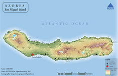
เซามีแกล (โปรตุเกส: São Miguel) เป็นเกาะที่ใหญ่ที่สุดและมีประชากรมากที่สุดในหมู่เกาะอะโซร์สของโปรตุเกส เกาะนี้มีพื้นที่ทั้งหมด 760 km2 (290 sq mi) และมีประชากรประมาณ 140,000 คน ซึ่ง 45,000 คนอาศัยอยู่ใน Ponta Delgada ซึ่งเป็นเมืองที่ใหญ่ที่สุดในเกาะนี้
| São Miguel (Ilha de São Miguel) | |
| The "Green" Island | |
| เกาะ (Ilha) | |
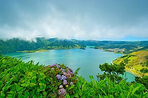
The Sete Cidades lagoon in São Miguel Island.
| |
| Official name: Ilha de São Miguel | |
| Name origin: Portuguese for Saint Michael | |
| Nickname: Ilha Verde | |
| ประเทศ | โปรตุเกส |
|---|---|
| Autonomous Region | อะโซร์ส |
| Islands | Eastern Group |
| สถานที่ | Azores Platform, Mid-Atlantic Ridge, มหาสมุทรแอตแลนติก |
| หมู่เกาะ | Azores |
| เขตเทศบาล | Lagoa, Ponta Delgada, Povoação, Nordeste, Ribeira Grande, Vila Franca do Campo |
| จุดสูงสุด | Pico da Vara |
| - location | Planalto dos Graminhais, Nordeste |
| - elevation | |
| จุดต่ำสุด | Sea level |
| - location | มหาสมุทรแอตแลนติก |
| - elevation | |
| ความยาว | 63.54 km (39 mi), Northwest-Southeast |
| Width | 15.63 km (10 mi), Southwest-Northeast |
| พื้นที่ | 744.55 ตร.กม. (287 ตร.ไมล์) |
| Population | 137,830 (2011) Census 2011 |
| Density | 185.1 /km² (479 /sq mi) |
| ไบโอม | Temperate, เมดิเตอร์เรเนียน |
| Geology | Alkali basalt, Tephra, Trachyte, Trachybasalt |
| Orogeny | ภูเขาไฟ |
| Period | สมัยโฮโลซีน |
| Demonym | Micaelense |
| Ethnic groups | Portuguese |
| Wikimedia Commons: Island of São Miguel (Azores) | |
| Geographic detail from Instituto Geográfico Português (2010) | |
ชื่อเซามีแกลของเกาะนี้แปลว่า "เซนต์มีคาเอล" ซึ่งหมายถึง อัครทูตสวรรค์มีคาเอล และเกาะนี้มีชื่อเล่นว่าเกาะสีเขียว (โปรตุเกส: Ilha Verde)


