ไฟล์:Saharat Thai Doem map.png

ขนาดของตัวอย่างนี้: 663 × 600 พิกเซล ความละเอียดอื่น: 265 × 240 พิกเซล | 531 × 480 พิกเซล | 962 × 870 พิกเซล
ดูภาพที่มีความละเอียดสูงกว่า (962 × 870 พิกเซล, ขนาดไฟล์: 189 กิโลไบต์, ชนิดไมม์: image/png)
| รูปภาพหรือไฟล์เสียงนี้ ต้นฉบับอยู่ที่ คอมมอนส์ รายละเอียดด้านล่าง เป็นข้อความที่แสดงผลจาก ไฟล์ต้นฉบับในคอมมอนส์
|
ความย่อ
| คำอธิบาย |
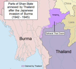
English: Parts of Shan State annexed by Thailand after the Japanese invasion of Burma. The map shows in purple the actual territories east of the Salween (Kengtung and part of Mongpan State) that were sanctioned by the Japanese authorities to become a new Thai province. Not all the territories claimed by Thailand in the Shan and Kayah states were granted by the Japanese.
Note: This is not a map of the farthest penetration of the Thai army accompanying the Japanese military in their Burma campaign. |
| วันที่ | |
| แหล่งที่มา | งานของตัว |
| ผู้สร้างสรรค์ | Xufanc |
การอนุญาตใช้สิทธิ
ข้าพเจ้า ในฐานะผู้ถือลิขสิทธิ์ของภาพหรือสื่อนี้ อนุญาตให้ใช้ภาพหรือสื่อนี้ภายใต้เงื่อนไขต่อไปนี้
ไฟล์นี้อยู่ภายใต้สัญญาอนุญาต ครีเอทีฟคอมมอนส์ แบบแสดงที่มา-อนุญาตแบบเดียวกัน 4.0 นานาชาติ
- คุณสามารถ:
- ที่จะแบ่งปัน – ที่จะทำสำเนา แจกจ่าย และส่งงานดังกล่าวต่อไป
- ที่จะเรียบเรียงใหม่ – ที่จะดัดแปลงงานดังกล่าว
- ภายใต้เงื่อนไขต่อไปนี้:
- แสดงที่มา – คุณต้องให้เกียรติเจ้าของงานอย่างเหมาะสม โดยเพิ่มลิงก์ไปยังสัญญาอนุญาต และระบุหากมีการเปลี่ยนแปลง คุณอาจทำเช่นนี้ได้ในรูปแบบใดก็ได้ตามควร แต่ต้องไม่ใช่ในลักษณะที่แนะว่าผู้ให้อนุญาตสนับสนุนคุณหรือการใช้งานของคุณ
- อนุญาตแบบเดียวกัน – หากคุณดัดแปลง เปลี่ยนรูป หรือต่อเติมงานนี้ คุณต้องใช้สัญญาอนุญาตแบบเดียวกันหรือแบบที่เหมือนกับสัญญาอนุญาตที่ใช้กับงานนี้เท่านั้น
ประวัติไฟล์
คลิกวันที่/เวลาเพื่อดูไฟล์ที่ปรากฏในขณะนั้น
| วันที่/เวลา | รูปย่อ | ขนาด | ผู้ใช้ | ความเห็น | |
|---|---|---|---|---|---|
| ปัจจุบัน | 20:01, 24 พฤษภาคม 2560 | | 962 × 870 (189 กิโลไบต์) | Xufanc | Undid malicious revision by User:Shoshui |
| 10:37, 12 มีนาคม 2559 |  | 962 × 870 (167 กิโลไบต์) | Shoshui | Reverted to version as of 07:52, 6 November 2015 (UTC) | |
| 16:37, 15 ธันวาคม 2558 |  | 962 × 870 (193 กิโลไบต์) | Xufanc | Corrected title | |
| 16:08, 15 ธันวาคม 2558 |  | 962 × 870 (194 กิโลไบต์) | Xufanc | Other wording | |
| 15:59, 15 ธันวาคม 2558 |  | 962 × 870 (208 กิโลไบต์) | Xufanc | Other wording | |
| 08:57, 9 พฤศจิกายน 2558 |  | 962 × 870 (208 กิโลไบต์) | Xufanc | status unclear region | |
| 10:03, 7 พฤศจิกายน 2558 |  | 962 × 870 (208 กิโลไบต์) | Xufanc | Status unclear region | |
| 14:52, 6 พฤศจิกายน 2558 |  | 962 × 870 (167 กิโลไบต์) | Xufanc | Mandalay and Taunggiy was as far as the Thai troops advanced, but the map is about the parts annexed by Thailand as 'Saharat Thai Doem'. It is not a map of the farthest penetration of the Phayap Army | |
| 13:25, 14 กันยายน 2558 |  | 962 × 870 (166 กิโลไบต์) | Shoshui | The area include Mandalay and Taunggyi. | |
| 13:16, 14 กันยายน 2558 |  | 962 × 870 (166 กิโลไบต์) | Shoshui | The area include Mandalay and Taunggyi. |
หน้าที่มีภาพนี้
หน้าต่อไปนี้ โยงมาที่ภาพนี้:
การใช้ไฟล์ข้ามโครงการ
วิกิอื่นต่อไปนี้ใช้ไฟล์นี้:
- การใช้บน en.wikipedia.org
- การใช้บน es.wikipedia.org
- การใช้บน fr.wikipedia.org
- การใช้บน it.wikipedia.org
- การใช้บน my.wikipedia.org
- การใช้บน ru.wikipedia.org
- การใช้บน uk.wikipedia.org
- การใช้บน vi.wikipedia.org
- การใช้บน zh.wikipedia.org