ดูภาพที่มีความละเอียดสูงกว่า(796 × 858 พิกเซล, ขนาดไฟล์: 161 กิโลไบต์, ชนิดไมม์: image/jpeg)

Wikimedia Commons logo รูปภาพหรือไฟล์เสียงนี้ ต้นฉบับอยู่ที่ คอมมอนส์ รายละเอียดด้านล่าง เป็นข้อความที่แสดงผลจาก ไฟล์ต้นฉบับในคอมมอนส์
คอมมอนส์เป็นเว็บไซต์ในโครงการสำหรับเก็บรวบรวมสื่อเสรี ที่ คุณสามารถช่วยได้

ความย่อ

คำอธิบาย
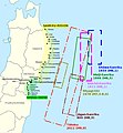
English: Historical tsunamis in the Sanriku area and selection of areas affected by the 2011 Tōhoku tsunami. (Source: Anawat Suppasri, Nobuo Shuto, Fumihiko Imamura, Shunichi Koshimura, Erick Mas, Ahmet Cevdet Yalciner: "Lessons Learned from the 2011 Great East Japan Tsunami: Performance of Tsunami Countermeasures, Coastal Buildings, and Tsunami Evacuation in Japan", Pure and Applied Geophysics, 170, (6-8), 2013, p. 993–1018, here p. 994, figure 1, DOI=10.1007/s00024-012-0511-7, online published: 7. July 2012. Modified and combined with: Nobuhito Mori, Daniel T. Cox, Tomohiro Yasuda, Hajime Mase: "Overview of the 2011 Tohoku Earthquake Tsunami Damage and Its Relation to Coastal Protection along the Sanriku Coast", Earthquake Spectra, 29 (S1), 2013, pp. 127-143, DOI=10.1193/1.4000118, here p. 131, fig. 3. And combined with: Tadashi Nakasu, Yuichi Ono, Wiraporn Pothisiri: "Why did Rikuzentakata have a high death toll in the 2011 Great East Japan Earthquake and Tsunami disaster? Finding the devastating disaster’s root causes", International Journal of Disaster Risk Reduction, Band=27, March 2018, pp. 21-36, DOI: 10.1016/j.ijdrr.2017.08.001, online published on 15 August 2017, here p. 23, fig. 1. Cf. Akemi Ishigaki, Hikari Higashi, Takako Sakamoto, Shigeki Shibahara: "The Great East-Japan Earthquake and Devastating Tsunami: An Update and Lessons from the Past Great Earthquakes in Japan since 1923", The Tohoku Journal of Experimental Medicine, 229, 4, 2013, pp. 287-299, DOI:10.1620/tjem.229.287, online published on 13 April 2013, here: p. 289, Fig. 1 "Distribution of the epicenters of the three Great Earthquakes."
Deutsch: Historische Tsunamis in der Sanriku-Region und Auswahl von Gebieten, die vom Tōhoku-Tsunami von 2011 betroffen waren. (Quelle: Anawat Suppasri, Nobuo Shuto, Fumihiko Imamura, Shunichi Koshimura, Erick Mas, Ahmet Cevdet Yalciner: "Lessons Learned from the 2011 Great East Japan Tsunami: Performance of Tsunami Countermeasures, Coastal Buildings, and Tsunami Evacuation in Japan", Pure and Applied Geophysics, 170, (6-8), 2013, S. 993–1018, hier S. 994, Abb. 1, DOI=10.1007/s00024-012-0511-7, online veröffentlicht am: 7. Juli 2012.) Verändert und kombiniert mit: Nobuhito Mori, Daniel T. Cox, Tomohiro Yasuda, Hajime Mase: "Overview of the 2011 Tohoku Earthquake Tsunami Damage and Its Relation to Coastal Protection along the Sanriku Coast", Earthquake Spectra, 29 (S1), 2013, S. 127-143, DOI=10.1193/1.4000118, hier S. 131, Abb. 3. Und kombiniert mit: Tadashi Nakasu, Yuichi Ono, Wiraporn Pothisiri: "Why did Rikuzentakata have a high death toll in the 2011 Great East Japan Earthquake and Tsunami disaster? Finding the devastating disaster’s root causes", International Journal of Disaster Risk Reduction, Band=27, März 2018, S. 21-36, DOI: 10.1016/j.ijdrr.2017.08.001, online veröffentlicht am 15. August 2017, hier S. 23, Abb. 1
วันที่
แหล่งที่มา งานของตัว; Original for content: Anawat Suppasri, Nobuo Shuto, Fumihiko Imamura, Shunichi Koshimura, Erick Mas, Ahmet Cevdet Yalciner: "Lessons Learned from the 2011 Great East Japan Tsunami: Performance of Tsunami Countermeasures, Coastal Buildings, and Tsunami Evacuation in Japan", Pure and Applied Geophysics, 170, (6-8), 2013, p. 993–1018, DOI=10.1007/s00024-012-0511-7, online published: 7. July 2012.
ผู้สร้างสรรค์ Modification and map: Anglo-Araneophilus~commonswiki, Original for content: Anawat Suppasri, Nobuo Shuto, Fumihiko Imamura, Shunichi Koshimura, Erick Mas, Ahmet Cevdet Yalciner: "Lessons Learned from the 2011 Great East Japan Tsunami: Performance of Tsunami Countermeasures, Coastal Buildings, and Tsunami Evacuation in Japan", Pure and Applied Geophysics, 170, (6-8), 2013, p. 993–1018, DOI=10.1007/s00024-012-0511-7, online published: 7. July 2012.
การอนุญาต
(การใช้ไฟล์นี้ใหม่)
w:th:ครีเอทีฟคอมมอนส์
แสดงที่มา อนุญาตแบบเดียวกัน
คุณสามารถ:
  • ที่จะแบ่งปัน – ที่จะทำสำเนา แจกจ่าย และส่งงานดังกล่าวต่อไป
  • ที่จะเรียบเรียงใหม่ – ที่จะดัดแปลงงานดังกล่าว
ภายใต้เงื่อนไขต่อไปนี้:
  • แสดงที่มา – คุณต้องให้เกียรติเจ้าของงานอย่างเหมาะสม โดยเพิ่มลิงก์ไปยังสัญญาอนุญาต และระบุหากมีการเปลี่ยนแปลง คุณอาจทำเช่นนี้ได้ในรูปแบบใดก็ได้ตามควร แต่ต้องไม่ใช่ในลักษณะที่แนะว่าผู้ให้อนุญาตสนับสนุนคุณหรือการใช้งานของคุณ
  • อนุญาตแบบเดียวกัน – หากคุณดัดแปลง เปลี่ยนรูป หรือต่อเติมงานนี้ คุณต้องใช้สัญญาอนุญาตแบบเดียวกันหรือแบบที่เหมือนกับสัญญาอนุญาตที่ใช้กับงานนี้เท่านั้น

คำบรรยายโดยย่อ

เพิ่มคำบรรยายทรรทัดเดียวเพื่อขยายความว่าไฟล์นี้มีอะไร

ไอเทมที่แสดงอยู่ในไฟล์นี้

ประกอบด้วย

ประวัติไฟล์

คลิกวันที่/เวลาเพื่อดูไฟล์ที่ปรากฏในขณะนั้น

วันที่/เวลารูปย่อขนาดผู้ใช้ความเห็น
ปัจจุบัน02:09, 15 สิงหาคม 2561รูปย่อสำหรับรุ่นเมื่อ 02:09, 15 สิงหาคม 2561796 × 858 (161 กิโลไบต์)Anglo-Araneophilus~commonswikiModified and combined with: Anawat Suppasri,Yo Fukutani,Yoshi Abe,Fumihiko Imamura: "Relationship between earthquake magnitude and tsunami height along the Tohoku coast based on historical tsunami trace database and the 2011 Great East Japan Tsunami", Report of Tsunami Engineering, Vol. 30 (2013), pp. 37-49, here: Fig. 2 ("Location of tsunami affected areas and historical tsunami height distribution").
15:21, 6 เมษายน 2561รูปย่อสำหรับรุ่นเมื่อ 15:21, 6 เมษายน 2561796 × 858 (158 กิโลไบต์)Anglo-Araneophilus~commonswikiModified and combined with: Tadashi Nakasu, Yuichi Ono, Wiraporn Pothisiri: "Why did Rikuzentakata have a high death toll in the 2011 Great East Japan Earthquake and Tsunami disaster? Finding the devastating disaster’s root causes", International Journal of Disaster Risk Reduction, Band=27, March 2018, pp. 21-36, DOI: 10.1016/j.ijdrr.2017.08.001, online published on 15 August 2017.
02:33, 2 เมษายน 2561รูปย่อสำหรับรุ่นเมื่อ 02:33, 2 เมษายน 2561796 × 858 (150 กิโลไบต์)Anglo-Araneophilus~commonswikiModified and combined with: Nobuhito Mori, Daniel T. Cox, Tomohiro Yasuda, Hajime Mase: "Overview of the 2011 Tohoku Earthquake Tsunami Damage and Its Relation to Coastal Protection along the Sanriku Coast", Earthquake Spectra, 29 (S1), 2013, pp. 127-143, DOI=10.1193/1.4000118.
22:42, 31 มีนาคม 2561รูปย่อสำหรับรุ่นเมื่อ 22:42, 31 มีนาคม 2561796 × 858 (130 กิโลไบต์)Anglo-Araneophilus~commonswiki{{Information |description ={{en|1=Historical tsunamis in the Sanriku area and selection of areas affected by the 2011 Tōhoku tsunami. (Source: Anawat Suppasri, Nobuo Shuto, Fumihiko Imamura, Shunichi Koshimura, Erick Mas, Ahmet Cevdet Yalciner: "Lessons Learned from the 2011 Great East Japan Tsunami: Performance of Tsunami Countermeasures, Coastal Buildings, and Tsunami Evacuation in Japan", Pure and Applied Geophysics, 170, (6-8), 2013, p. 993–1018, here p. 994, figure 1, DOI=10.1007/s000...

หน้าต่อไปนี้ โยงมาที่ภาพนี้:

การใช้ไฟล์ข้ามโครงการ

วิกิอื่นต่อไปนี้ใช้ไฟล์นี้:

ข้อมูลเกี่ยวกับภาพ