ไฟล์:PonticKingdom.png

ขนาดของตัวอย่างนี้: 718 × 600 พิกเซล ความละเอียดอื่น: 287 × 240 พิกเซล | 575 × 480 พิกเซล | 919 × 768 พิกเซล | 1,226 × 1,024 พิกเซล | 1,551 × 1,296 พิกเซล
ดูภาพที่มีความละเอียดสูงกว่า (1,551 × 1,296 พิกเซล, ขนาดไฟล์: 265 กิโลไบต์, ชนิดไมม์: image/png)
| รูปภาพหรือไฟล์เสียงนี้ ต้นฉบับอยู่ที่ คอมมอนส์ รายละเอียดด้านล่าง เป็นข้อความที่แสดงผลจาก ไฟล์ต้นฉบับในคอมมอนส์
|

|
ภาพแผนที่ทางประวัติศาสตร์นี้ ควรจะถูกสร้างใหม่เป็นกราฟิกส์เวกเตอร์ ซึ่งมีข้อดีอีกหลายประการ ดูเพิ่มเติมที่คอมมอนส์:สื่อต้องการเก็บกวาดสำหรับสารสนเทศเพิ่มเติม หากภาพนี้มีในรูปแบบกราฟิกส์เวกเตอร์อยู่แล้ว กรุณาอัปโหลดและแทนที่แม่แบบนี้ด้วย
{{vector version available|ชื่อภาพใหม่}}
แนะนำเป็นอย่างยิ่งให้ตั้งชื่อไฟล์เวกเตอร์ใหม่นั้นในรูปแบบ "PonticKingdom.svg" แล้วใส่แม่แบบ Vector version available (หรือ Vva) ซึ่งไม่ต้องใช้พารามิเตอร์ ชื่อภาพใหม่ |
| คำอธิบาย |
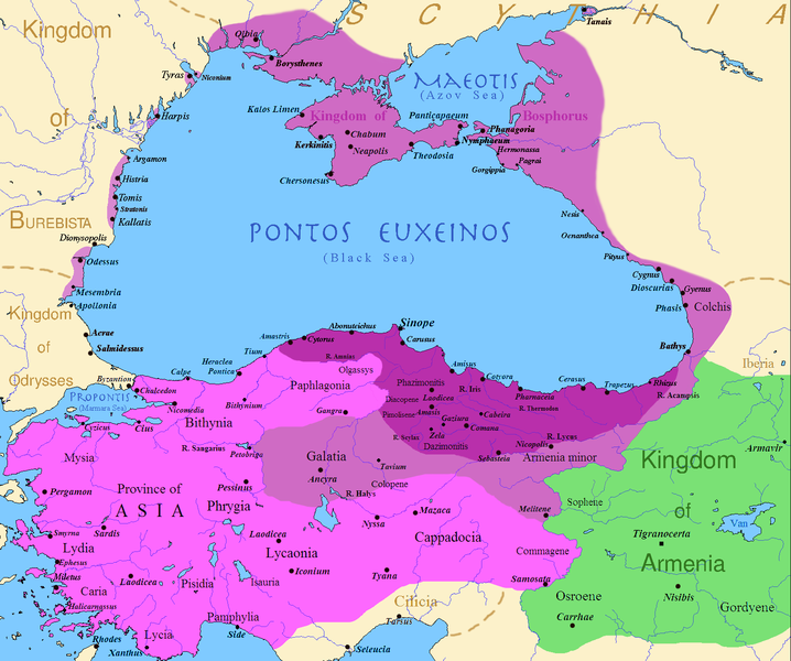
English: Map of the Kingdom of Pontus, Before the reign of Mithridates VI (darkest purple), after his conquests (purple), and his conquests in the first Mithridatic wars (pink); little adds (ancient shorelines & some greek colonies under Mithridate's rule) according with V. Yanko-Hombach, A.S. Gilbert, N. Panin, P. M. Dolukhanov: The Black Sea Flood Question: Changes in Coastline, Climate, and Human Settlement, Springer, Netherlands, 2007, and with Appianus, Plutarchus & Strabo. |
| วันที่ | |
| แหล่งที่มา | I (Javierfv1212 (talk)) created this work entirely by myself. Sources, Cambridge Ancient history volume 9, Penguin atlas of Greek history and the Foreign Policy of Mithridates VI Eupator. |
| ผู้สร้างสรรค์ | Javierfv1212 (talk) |
การอนุญาตใช้สิทธิ
| งานนี้ได้ถูกเผยแพร่สู่สาธารณสมบัติโดยเจ้าของ Javierfv1212 ที่ วิกิพีเดียภาษาอังกฤษ ซึ่งมีผลทั่วโลก ในบางประเทศ การกระทำดังกล่าวอาจไม่สามารถทำได้ตามกฎหมาย Javierfv1212 อนุญาตให้ทุกคนมีสิทธิ์ในการใช้ไฟล์นี้ในทุกเหตุผลการใช้ โดยไม่มีมีเงื่อนไข เว้นแต่กฎหมายไม่อนุญาตให้ทำเช่นนั้น |
บันทึกการอัพโหลด
นำเข้าจาก en.wikipedia มายังคอมมอนส์ โดย Falcorian โดยใช้ CommonsHelper
The original description page was here. All following user names refer to en.wikipedia.
- 2009-07-19 23:42 Javierfv1212 1551×1296× (205182 bytes) {{Information |Description = Map of the Kingdom of Pontus, Before the reign of mithridates VI (darkest purple), after his conquests (purple), and his conquests in the first Mithridatic wars (pink). |Source = I (~~~) created this work entirel
ประวัติไฟล์
คลิกวันที่/เวลาเพื่อดูไฟล์ที่ปรากฏในขณะนั้น
| วันที่/เวลา | รูปย่อ | ขนาด | ผู้ใช้ | ความเห็น | |
|---|---|---|---|---|---|
| ปัจจุบัน | 09:00, 9 ธันวาคม 2560 | | 1,551 × 1,296 (265 กิโลไบต์) | SteinsplitterBot | Bot: Image rotated by 90° |
| 07:00, 9 ธันวาคม 2560 |  | 1,296 × 1,551 (316 กิโลไบต์) | SteinsplitterBot | Bot: Image rotated by 270° | |
| 00:54, 23 กันยายน 2559 |  | 1,551 × 1,296 (265 กิโลไบต์) | Hohum | Lighten water area | |
| 18:21, 9 สิงหาคม 2559 |  | 1,551 × 1,296 (260 กิโลไบต์) | MAXHO | Details : more cities & shoreline of this time | |
| 03:57, 2 ตุลาคม 2558 |  | 1,551 × 1,296 (249 กิโลไบต์) | Spiridon Ion Cepleanu | Cosmetic again | |
| 19:55, 30 กันยายน 2558 |  | 1,551 × 1,296 (247 กิโลไบต์) | Spiridon Ion Cepleanu | Cosmetic colours & background names | |
| 21:21, 7 เมษายน 2557 |  | 1,551 × 1,296 (225 กิโลไบต์) | Spiridon Ion Cepleanu | Little changes (ancient shoreline & some greek colonies under Pontic rule) according with V. Yanko-Hombach, A.S. Gilbert, N. Panin, P. M. Dolukhanov: ''The Black Sea Flood Question: Changes in Coastline, Climate, and Human Settlement'', Springer, Nethe... | |
| 11:14, 20 กรกฎาคม 2552 |  | 1,551 × 1,296 (200 กิโลไบต์) | File Upload Bot (Magnus Manske) | {{BotMoveToCommons|en.wikipedia|year={{subst:CURRENTYEAR}}|month={{subst:CURRENTMONTHNAME}}|day={{subst:CURRENTDAY}}}} {{Information |Description={{en|Map of the Kingdom of Pontus, Before the reign of mithridates VI (darkest purple), after his conquests |
หน้าที่มีภาพนี้
หน้าต่อไปนี้ โยงมาที่ภาพนี้:
การใช้ไฟล์ข้ามโครงการ
วิกิอื่นต่อไปนี้ใช้ไฟล์นี้:
- การใช้บน ar.wikipedia.org
- การใช้บน ast.wikipedia.org
- การใช้บน azb.wikipedia.org
- การใช้บน az.wikipedia.org
- การใช้บน bg.wikipedia.org
- การใช้บน br.wikipedia.org
- การใช้บน ca.wikipedia.org
- การใช้บน cs.wikipedia.org
- การใช้บน da.wikipedia.org
- การใช้บน de.wikipedia.org
- การใช้บน el.wikipedia.org
- การใช้บน en.wikipedia.org
- การใช้บน es.wikipedia.org
- การใช้บน et.wikipedia.org
- การใช้บน eu.wikipedia.org
- การใช้บน fa.wikipedia.org
- การใช้บน fr.wikipedia.org
ดูการใช้ข้ามโครงการเพิ่มเติมของไฟล์นี้