ไฟล์:Dhauliganga and Rishiganga Valleys.jpg

ขนาดของตัวอย่างนี้: 411 × 600 พิกเซล ความละเอียดอื่น: 164 × 240 พิกเซล | 329 × 480 พิกเซล | 526 × 768 พิกเซล | 702 × 1,024 พิกเซล | 1,925 × 2,809 พิกเซล
ดูภาพที่มีความละเอียดสูงกว่า (1,925 × 2,809 พิกเซล, ขนาดไฟล์: 2.76 เมกะไบต์, ชนิดไมม์: image/jpeg)
| รูปภาพหรือไฟล์เสียงนี้ ต้นฉบับอยู่ที่ คอมมอนส์ รายละเอียดด้านล่าง เป็นข้อความที่แสดงผลจาก ไฟล์ต้นฉบับในคอมมอนส์
|
ความย่อ
| คำอธิบาย |
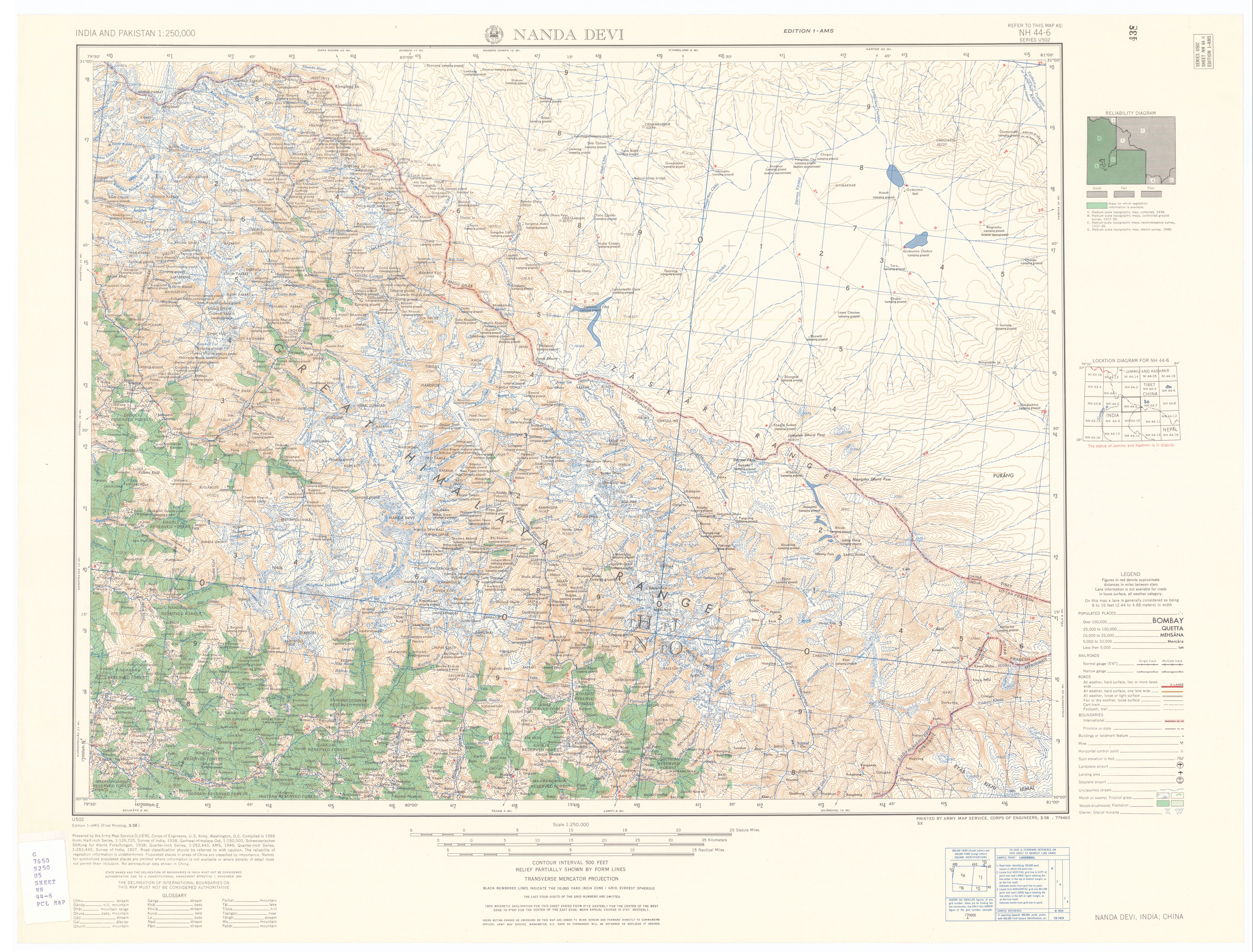
English: The Dhauliganga and Rishiganga river valleys in the Garhwal Himalayas of Uttarakhand state, India |
||||||||||||||||||||||||
| วันที่ | |||||||||||||||||||||||||
| แหล่งที่มา | From the Map NH 44-6 series U502 in India and Pakistan 1:250,000 Series U502, U.S. Army Map Service, 1955- at the University of Texas at Austin, Perry-Castañeda Library Map Collection. | ||||||||||||||||||||||||
| ผู้สร้าง |
Prepared by the US Army Map Service (LUEN), Corps of Engineers, U. S. Army, Washington, D. C. Compiled in 1955 (from: Half-inch Series, 1:125,720, Survey of India, 1938; Garhwal-Himalaya-Ost, 1:150,000, Schweizerischen Stiftung fur Alpine Forschungen, 1938; Quarter-inch Series, 1:253,440, AMS, 1946; Quarter-inch Series, 1:253,440, Survey of India, 1927). Cropped and map margins edited by Fowler&fowler (คุย) 00:36, 10 February 2021 (UTC) |
||||||||||||||||||||||||
| พิกัดอ้างอิงทางภูมิศาสตร์ | ถ้ามีความไม่เหมาะสม กรุณาตั้ง warp_status = skip เพื่อซ่อน | ||||||||||||||||||||||||
| เวอร์ชันอื่น |
|

.jpg)

| ตำแหน่งที่ตั้งกล้อง | | ภาพนี้และภาพอื่น ๆ ณ สถานที่เดียวกันที่ OpenStreetMap |
|---|
การอนุญาตใช้สิทธิ
งานนี้เป็น สาธารณสมบัติ ในประเทศสหรัฐอเมริกา เนื่องจากเป็นงานของรัฐบาลกลางสหรัฐอเมริกา ทั้งนี้ ตามความของมาตรา 105 หมวด 1 ลักษณะ 17 แห่งประมวลกฎหมายสหรัฐอเมริกา ดูเพิ่มที่ ลิขสิทธิ์
หมายเหตุ ข้อความข้างต้นใช้บังคับแก่งานของรัฐบาลกลางสหรัฐอเมริกาเท่านั้น งานของรัฐใด ๆ ในสหรัฐอเมริกา ดินแดน เครือจักรภพ เทศมณฑล เทศบาล หรือองค์กรปกครองส่วนท้องถิ่นอื่นใด ไม่ถึอเป็นงานที่เป็นสาธารณสมบัติตามประมวลกฎหมายนี้ นอกจากนี้ แม่แบบนี้ไม่ใช้กับตราไปรษณียากรแบบใด ๆ ที่กรมไปรษณีย์แห่งสหรัฐอเมริกา นำออกใช้ตั้งแต่ ค.ศ. 1978 (พ.ศ. 2521) เป็นต้นมา ซึ่งมีลิขสิทธิ์และไม่เป็นสาธารณสมบัติ (ดูรายละเอียดที่ ระเบียบแห่งสำนักงานลิขสิทธิ์ บทย่อที่ 2 ข้อ 206.02 (b))
|
 | |
| ไฟล์นี้ได้ถูกระบุว่าไม่มีข้อจำกัดภายใต้กฎหมายลิขสิทธิ์ รวมถึงสิทธิที่เกี่ยวข้องและที่ใกล้เคียงกัน | ||
ประวัติไฟล์
คลิกวันที่/เวลาเพื่อดูไฟล์ที่ปรากฏในขณะนั้น
| วันที่/เวลา | รูปย่อ | ขนาด | ผู้ใช้ | ความเห็น | |
|---|---|---|---|---|---|
| ปัจจุบัน | 07:36, 10 กุมภาพันธ์ 2564 | | 1,925 × 2,809 (2.76 เมกะไบต์) | Fowler&fowler | Uploaded a work by Prepared by the US Army Map Service (LUEN), Corps of Engineers, U. S. Army, Washington, D. C. Compiled in 1955 (from: Half-inch Series, 1:125,720, Survey of India, 1938; Garhwal-Himalaya-Ost, 1:150,000, Schweizerischen Stiftung fur Alpine Forschungen, 1938; Quarter-inch Series, 1:253,440, AMS, 1946; Quarter-inch Series, 1:253,440, Survey of India, 1927). Cropped and map margins edited by ~~~~ from From the [http://legacy.lib.utexas.edu/maps/ams/india/nh-44-06.jpg Map NH 44... |
หน้าที่มีภาพนี้
หน้าต่อไปนี้ โยงมาที่ภาพนี้:
การใช้ไฟล์ข้ามโครงการ
วิกิอื่นต่อไปนี้ใช้ไฟล์นี้:
- การใช้บน en.wikipedia.org
- การใช้บน fa.wikipedia.org
- การใช้บน hi.wikipedia.org
- การใช้บน kn.wikipedia.org
- การใช้บน ur.wikipedia.org