ไฟล์:Demis-kurils-russian names.png
ไม่มีภาพที่มีรายละเอียดสูงกว่านี้
Demis-kurils-russian_names.png (663 × 462 พิกเซล, ขนาดไฟล์: 70 กิโลไบต์, ชนิดไมม์: image/png)
| รูปภาพหรือไฟล์เสียงนี้ ต้นฉบับอยู่ที่ คอมมอนส์ รายละเอียดด้านล่าง เป็นข้อความที่แสดงผลจาก ไฟล์ต้นฉบับในคอมมอนส์
|
ความย่อ
| คำอธิบาย |
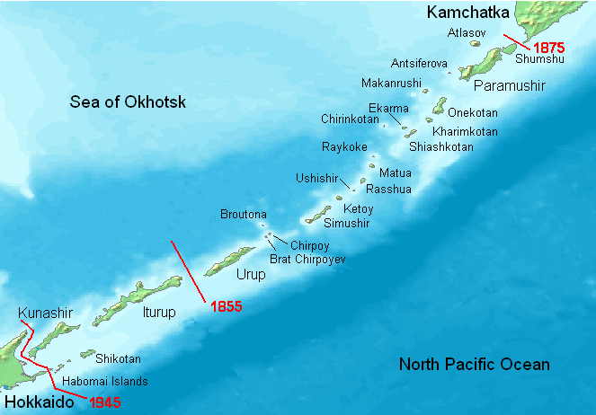
English: Kuril Islands overview map with current Russian names (English transliteration). Borders of Shimoda Treaty (1855) and Treaty of St. Petersburg (1875) shown in red. Currently all islands northeast of Hokkaido are administered by Russia. Note: Ushishir actually consists of 2 islands: Ryponkicha (northeast) and Yankicha (southwest).
Bahasa Indonesia: Peta yang menampilkan nama-nama pulau di Kepulauan Kuril dalam bahasa Rusia (transliterasi Inggris). Perbatasan dalam Traktat Shimoda (1855) dan Traktat Sankt-Peterburg (1875) ditunjukkan dalam warna merah. Sekarang semua pulau-pulau di timur laut Hokkaido dikuasai oleh Rusia. Catatan: Ushishir sebenarnya terdiri dari 2 pulau: Ryponkicha (timur laut) dan Yankicha (barat daya). |
| วันที่ | |
| แหล่งที่มา | งานของตัว |
| ผู้สร้างสรรค์ | Hardscarf |
| เวอร์ชันอื่น |
|

การอนุญาตใช้สิทธิ
This image is in the public domain because it came from the site https://www.demis.nl/products/web-map-server/examples/ and was released by the copyright holder. Permission is granted to copy, distribute and/or modify this map since it is based on free of copyright images from: www.demis.nl. See also approval email on de.wp and its clarification.
|
| This work has been released into the public domain by its copyright holder, www.demis.nl. This applies worldwide. ในบางประเทศ การกระทำดังกล่าวอาจไม่สามารถทำได้ตามกฎหมาย www.demis.nl อนุญาตให้ทุกคนมีสิทธิ์ในการใช้ไฟล์นี้ในทุกเหตุผลการใช้ โดยไม่มีมีเงื่อนไข เว้นแต่กฎหมายไม่อนุญาตให้ทำเช่นนั้น
|
ประวัติไฟล์
คลิกวันที่/เวลาเพื่อดูไฟล์ที่ปรากฏในขณะนั้น
| วันที่/เวลา | รูปย่อ | ขนาด | ผู้ใช้ | ความเห็น | |
|---|---|---|---|---|---|
| ปัจจุบัน | 01:27, 23 พฤษภาคม 2551 | | 663 × 462 (70 กิโลไบต์) | ChrisDHDR | added the border since 1945 |
| 03:00, 24 พฤศจิกายน 2549 |  | 663 × 462 (70 กิโลไบต์) | Hardscarf | Kuril Islands overviewmap with actual Russian names (English transliteration). Borders of Shimoda Treaty (1855) and Treaty of St. Petersburg (1875) shown in red. Currently all islands northwest of Hokkaido are administered by Russia. Note: Ushishir actua |
หน้าที่มีภาพนี้
หน้าต่อไปนี้ โยงมาที่ภาพนี้:
การใช้ไฟล์ข้ามโครงการ
วิกิอื่นต่อไปนี้ใช้ไฟล์นี้:
- การใช้บน ace.wikipedia.org
- การใช้บน af.wikipedia.org
- การใช้บน ar.wikipedia.org
- การใช้บน az.wikipedia.org
- การใช้บน be.wikipedia.org
- การใช้บน bg.wikipedia.org
- การใช้บน br.wikipedia.org
- การใช้บน ca.wikipedia.org
- การใช้บน ckb.wikipedia.org
- การใช้บน cs.wikipedia.org
- การใช้บน da.wikipedia.org
- การใช้บน de.wikipedia.org
- Kurilen
- Vierte Kurilenstraße
- Kurilenstraße
- Zweite Kurilenstraße
- Nemuro-Straße
- Fries-Straße
- Luschin-Straße
- Krusenstern-Straße
- Jekaterina-Straße
- Boussole-Straße
- Kurilenstraßen
- Nadeschda-Straße
- 27. Armee (Japanisches Kaiserreich)
- 91. Division (Japanisches Kaiserreich)
- 5. Regionalarmee
- Juli 1990
- Vorlage:Navigationsleiste Kurilenstraßen
- การใช้บน en.wikipedia.org
- การใช้บน en.wiktionary.org
- การใช้บน es.wikipedia.org
ดูการใช้ข้ามโครงการเพิ่มเติมของไฟล์นี้