ไฟล์:Bang Kachao Landsat.jpg
Bang_Kachao_Landsat.jpg (720 × 480 พิกเซล, ขนาดไฟล์: 246 กิโลไบต์, ชนิดไมม์: image/jpeg)
| รูปภาพหรือไฟล์เสียงนี้ ต้นฉบับอยู่ที่ คอมมอนส์ รายละเอียดด้านล่าง เป็นข้อความที่แสดงผลจาก ไฟล์ต้นฉบับในคอมมอนส์
|
ความย่อ
| คำอธิบาย |
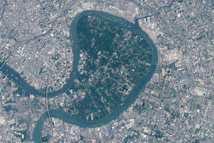
English: In the heart of Thailand’s most populous city, an oasis stands out from the urban landscape like a great “green lung.” That’s the nickname given to Bang Kachao—a lush protected area that has escaped the dense development seen elsewhere in Bangkok.
The city is built on the alluvial plain of the Chao Phraya River. Toward the southern end, near the Gulf of Thailand, is an old meander that never quite formed an oxbow lake. That meander traces the boundary of Bang Kachao, which TIME magazine once called the “best urban oasis” in Asia. On February 2, 2014, the Operational Land Imager (OLI) on Landsat 8 captured this natural-color view of Bang Kachao (also called Bang Krachao or Bang Kra Jao). The top image is a close up view of the region outlined with a rectangle in the bottom image. Bang Kachao is actually an island—albeit an artificial one. The Klong Lad Pho canal, built at the neck of the oxbow, allows water from the Chao Phraya to more quickly reach the sea. The canal contains floodgates that control water levels to prevent flooding. Immediately west of the canal is the Bhumibol Bridge, which twice crosses the Chao Phraya River. Look east of the mid-bridge interchange, however, and a stark transition occurs, as the urban jungle gives way to about 2,000 hectares of rural jungle, villages, and farmland. According to a travel story in The New York Times, Bang Kachao is gaining popularity among tourists lured by bike tours, a floating farmers’ market, and the relaxed atmosphere.[1] |
| วันที่ | |
| แหล่งที่มา | http://earthobservatory.nasa.gov/blogs/earthmatters/2015/03/03/february-puzzler-answer-bang-kachao/ |
| ผู้สร้างสรรค์ | NASA Earth Observatory image by Jesse Allen, using Landsat data from the U.S. Geological Survey. |
การอนุญาตใช้สิทธิ
| ภาพนี้เป็นสาธารณสมบัติ เนื่องจากเป็นภาพที่สร้างขึ้นโดยองค์การบริหารการบินและอวกาศแห่งชาติ (NASA) ซึ่งตามนโยบายด้านลิขสิทธิ์ของนาซาระบุไว้ว่า "ภาพและสื่อต่าง ๆ ของนาซาไม่ได้รับการคุ้มครองโดยลิขสิทธิ์ยกเว้นจะระบุไว้ว่ามีลิขสิทธิ์" ดูเพิ่มที่ หน้านโยบายด้านลิขสิทธิ์ของนาซา หรือ นโยบายการใช้ภาพของ JPL | ||
 |
คำเตือน:
|
ประวัติไฟล์
คลิกวันที่/เวลาเพื่อดูไฟล์ที่ปรากฏในขณะนั้น
| วันที่/เวลา | รูปย่อ | ขนาด | ผู้ใช้ | ความเห็น | |
|---|---|---|---|---|---|
| ปัจจุบัน | 19:39, 3 พฤษภาคม 2559 | | 720 × 480 (246 กิโลไบต์) | Paul 012 | {{Information |Description ={{en|1=In the heart of Thailand’s most populous city, an oasis stands out from the urban landscape like a great “green lung.” That’s the nickname given to Bang Kachao—a lush protected area that has escaped the d... |
หน้าที่มีภาพนี้
หน้าต่อไปนี้ โยงมาที่ภาพนี้:
การใช้ไฟล์ข้ามโครงการ
วิกิอื่นต่อไปนี้ใช้ไฟล์นี้:
- การใช้บน de.wikipedia.org
- การใช้บน de.wikivoyage.org
- การใช้บน en.wikipedia.org
- การใช้บน uk.wikipedia.org