ไฟล์:AONBSUK.png
ขนาดของตัวอย่างนี้: 580 × 599 พิกเซล ความละเอียดอื่น: 232 × 240 พิกเซล | 465 × 480 พิกเซล | 886 × 915 พิกเซล
ดูภาพที่มีความละเอียดสูงกว่า (886 × 915 พิกเซล, ขนาดไฟล์: 37 กิโลไบต์, ชนิดไมม์: image/png)
| รูปภาพหรือไฟล์เสียงนี้ ต้นฉบับอยู่ที่ คอมมอนส์ รายละเอียดด้านล่าง เป็นข้อความที่แสดงผลจาก ไฟล์ต้นฉบับในคอมมอนส์
|

|
This file requires updating because: AONB expansion to the Dee Valley, and changes surrounding the establishment of the South Downs National Park In doing so, you could add a timestamp to the file.
|
| คำอธิบาย |
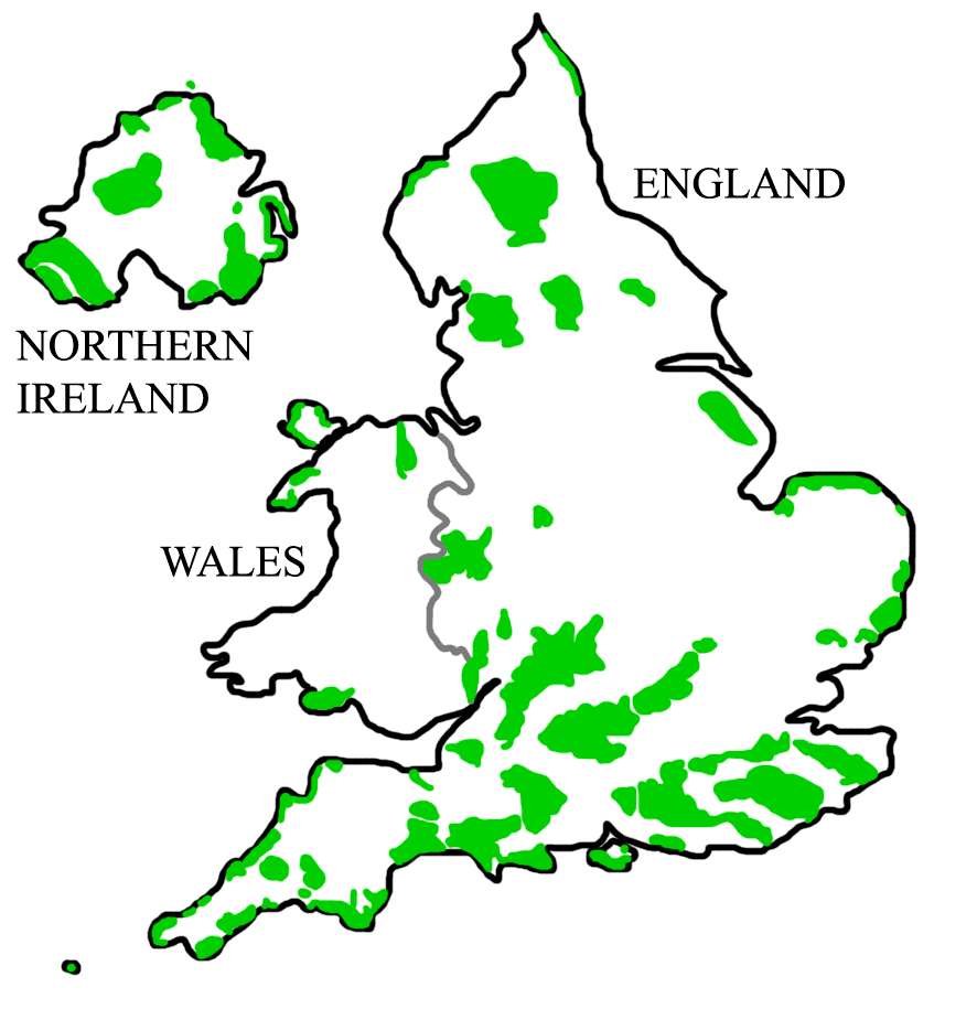
English: A map of all Areas of Outstanding Natural Beauty (AONB) in England, Wales, and Northern Ireland. การอนุญาตใช้สิทธิHistory of Image:AONBSUK.jpg |
| วันที่ |
22 กันยายน พ.ศ. 2551 (original upload date) |
| แหล่งที่มา | งานของตัว (Original text: self-made) |
| ผู้สร้างสรรค์ | Asdfasdf1231234 (talk) |

|
ภาพแผนที่ระบุตำแหน่งนี้ ควรจะถูกสร้างใหม่เป็นกราฟิกส์เวกเตอร์ ซึ่งมีข้อดีอีกหลายประการ ดูเพิ่มเติมที่คอมมอนส์:สื่อต้องการเก็บกวาดสำหรับสารสนเทศเพิ่มเติม หากภาพนี้มีในรูปแบบกราฟิกส์เวกเตอร์อยู่แล้ว กรุณาอัปโหลดและแทนที่แม่แบบนี้ด้วย
{{vector version available|ชื่อภาพใหม่}}
แนะนำเป็นอย่างยิ่งให้ตั้งชื่อไฟล์เวกเตอร์ใหม่นั้นในรูปแบบ "AONBSUK.svg" แล้วใส่แม่แบบ Vector version available (หรือ Vva) ซึ่งไม่ต้องใช้พารามิเตอร์ ชื่อภาพใหม่ |
การอนุญาตใช้สิทธิ
718 Bot ที่ วิกิพีเดียภาษาอังกฤษ ในฐานะผู้ถือลิขสิทธิ์ของภาพหรือสื่อนี้ อนุญาตให้ใช้ภาพหรือสื่อนี้ภายใต้เงื่อนไขต่อไปนี้
ไฟล์นี้อยู่ภายใต้สัญญาอนุญาตครีเอทีฟคอมมอนส์ รุ่น แสดงที่มา 3.0 ต้นฉบับ
การแสดงที่มา: 718 Bot ที่ วิกิพีเดียภาษาอังกฤษ
- คุณสามารถ:
- ที่จะแบ่งปัน – ที่จะทำสำเนา แจกจ่าย และส่งงานดังกล่าวต่อไป
- ที่จะเรียบเรียงใหม่ – ที่จะดัดแปลงงานดังกล่าว
- ภายใต้เงื่อนไขต่อไปนี้:
- แสดงที่มา – คุณต้องให้เกียรติเจ้าของงานอย่างเหมาะสม โดยเพิ่มลิงก์ไปยังสัญญาอนุญาต และระบุหากมีการเปลี่ยนแปลง คุณอาจทำเช่นนี้ได้ในรูปแบบใดก็ได้ตามควร แต่ต้องไม่ใช่ในลักษณะที่แนะว่าผู้ให้อนุญาตสนับสนุนคุณหรือการใช้งานของคุณ
บันทึกการอัพโหลด
นำเข้าจาก en.wikipedia มายังคอมมอนส์ โดย Rawet06
The original description page was here. All following user names refer to en.wikipedia.
- 2008-09-22 21:32 718 Bot 886×915× (247674 bytes) == Summary == {{Information |Description=A map of all [[Areas of Outstanding Natural Beauty]] (AONB) in [[England]], [[Wales]], and [[Northern Ireland]]. |Source=self-made |Date=5th April, 2008 |Location= |Author=[[User:Asdfasdf1231234|Asdfasdf1231234]] (
ประวัติไฟล์
คลิกวันที่/เวลาเพื่อดูไฟล์ที่ปรากฏในขณะนั้น
| วันที่/เวลา | รูปย่อ | ขนาด | ผู้ใช้ | ความเห็น | |
|---|---|---|---|---|---|
| ปัจจุบัน | 02:18, 11 สิงหาคม 2554 | | 886 × 915 (37 กิโลไบต์) | Jbarta | remove jpg artifacts, reduce colors |
| 23:29, 11 ธันวาคม 2551 |  | 886 × 915 (242 กิโลไบต์) | Rawet06 | {{Information |Description={{en|A map of all en:Areas of Outstanding Natural Beauty (AONB) in en:England, en:Wales, and en:Northern Ireland.<br/> == Licensing: == ==History of Image:AONBSUK.jpg== *2008-08-31T04:40:48Z [[:en:User:Bkell |
หน้าที่มีภาพนี้
หน้าต่อไปนี้ โยงมาที่ภาพนี้:
การใช้ไฟล์ข้ามโครงการ
วิกิอื่นต่อไปนี้ใช้ไฟล์นี้:
- การใช้บน ar.wikipedia.org
- การใช้บน de.wikipedia.org
- Scilly-Inseln
- Anglesey
- Cotswolds
- South Downs
- Malvern Hills
- Mendip Hills
- Mourne Mountains
- Gower-Halbinsel
- Quantock Hills
- Lleyn-Halbinsel
- Chiltern Hills
- Lincolnshire Wolds
- Wye Valley
- Howardian Hills
- Strangford Lough
- Bodmin Moor
- Kent Downs
- Nidderdale
- Sperrin Mountains
- Arnside and Silverdale
- Forest of Bowland
- Vorlage:Navigationsleiste Area of Outstanding Natural Beauty
- North Pennines
- Rame Head (Cornwall)
- Dedham Vale
- Antrim Coast and Glens
- Surrey Hills
- Cornwall AONB
- Northumberland Coast
- Isle of Wight AONB
- Norfolk Coast
- Suffolk Coast and Heaths
- การใช้บน de.wikivoyage.org
- การใช้บน en.wikipedia.org
- การใช้บน fr.wikipedia.org
ดูการใช้ข้ามโครงการเพิ่มเติมของไฟล์นี้