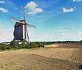
ไฟล์:Steenvoorde, Le Noordmeulen ( PA00107830) (2).jpg

ดูภาพที่มีความละเอียดสูงกว่า (3,566 × 3,032 พิกเซล, ขนาดไฟล์: 2.72 เมกะไบต์, ชนิดไมม์: image/jpeg)
| รูปภาพหรือไฟล์เสียงนี้ ต้นฉบับอยู่ที่ คอมมอนส์ รายละเอียดด้านล่าง เป็นข้อความที่แสดงผลจาก ไฟล์ต้นฉบับในคอมมอนส์
|
ความย่อ
| คำอธิบายSteenvoorde, Le Noordmeulen ( PA00107830) (2).jpg |
|
||||||||||||||||||||||||||
| วันที่ | |||||||||||||||||||||||||||
| แหล่งที่มา | งานของตัว | ||||||||||||||||||||||||||
| ผู้สร้างสรรค์ |
creator QS:P170,Q97949455 |
||||||||||||||||||||||||||
| การอนุญาต (การใช้ไฟล์นี้ใหม่) |
|
||||||||||||||||||||||||||
| เวอร์ชันอื่น |
 |
||||||||||||||||||||||||||
| ตำแหน่งของวัตถุหรือสถานที่ | 50° 48′ 53.91″ เหนือ, 2° 34′ 09.74″ ตะวันออก | ภาพนี้และภาพอื่น ๆ ณ สถานที่เดียวกันที่ OpenStreetMap |
|---|
การอนุญาตใช้สิทธิ
- คุณสามารถ:
- ที่จะแบ่งปัน – ที่จะทำสำเนา แจกจ่าย และส่งงานดังกล่าวต่อไป
- ที่จะเรียบเรียงใหม่ – ที่จะดัดแปลงงานดังกล่าว
- ภายใต้เงื่อนไขต่อไปนี้:
- แสดงที่มา – คุณต้องให้เกียรติเจ้าของงานอย่างเหมาะสม โดยเพิ่มลิงก์ไปยังสัญญาอนุญาต และระบุหากมีการเปลี่ยนแปลง คุณอาจทำเช่นนี้ได้ในรูปแบบใดก็ได้ตามควร แต่ต้องไม่ใช่ในลักษณะที่แนะว่าผู้ให้อนุญาตสนับสนุนคุณหรือการใช้งานของคุณ
- อนุญาตแบบเดียวกัน – หากคุณดัดแปลง เปลี่ยนรูป หรือต่อเติมงานนี้ คุณต้องใช้สัญญาอนุญาตแบบเดียวกันหรือแบบที่เหมือนกับสัญญาอนุญาตที่ใช้กับงานนี้เท่านั้น

|
This image was awarded with the 9th prize in the national contest of ประเทศฝรั่งเศส in Wiki Loves Monuments 2019 Other languages:
العربية | беларуская (тарашкевіца) | বাংলা | Deutsch | English | British English | español | français | hrvatski | italiano | ქართული | македонски | norsk (bokmål) | norsk (nynorsk) | português do Brasil | русский | slovenščina | svenska | українська | +/− |

|
ภาพถ่ายนี้อัปโหลดมาโดยเป็นส่วนหนึ่งของการประกวดภาพถ่าย Wiki Loves Monuments 2019.
Afrikaans ∙ Alemannisch ∙ azərbaycanca ∙ Bahasa Indonesia ∙ Bahasa Melayu ∙ Bikol Central ∙ bosanski ∙ brezhoneg ∙ català ∙ čeština ∙ Cymraeg ∙ dansk ∙ davvisámegiella ∙ Deutsch ∙ eesti ∙ English ∙ español ∙ Esperanto ∙ euskara ∙ français ∙ Frysk ∙ Gaeilge ∙ galego ∙ hrvatski ∙ Ido ∙ italiano ∙ latviešu ∙ Lëtzebuergesch ∙ Malagasy ∙ magyar ∙ Malti ∙ Nederlands ∙ norsk ∙ norsk nynorsk ∙ norsk bokmål ∙ polski ∙ português ∙ português do Brasil ∙ română ∙ shqip ∙ sicilianu ∙ slovenčina ∙ slovenščina ∙ suomi ∙ svenska ∙ Tagalog ∙ Türkçe ∙ Yorùbá ∙ Zazaki ∙ Ελληνικά ∙ беларуская ∙ беларуская (тарашкевіца) ∙ български ∙ кыргызча ∙ македонски ∙ русский ∙ српски / srpski ∙ українська ∙ ქართული ∙ հայերեն ∙ नेपाली ∙ हिन्दी ∙ বাংলা ∙ മലയാളം ∙ ไทย ∙ 한국어 ∙ +/− |
 |

|
العربية ∙ جازايرية ∙ беларуская ∙ беларуская (тарашкевіца) ∙ български ∙ বাংলা ∙ català ∙ čeština ∙ Cymraeg ∙ Deutsch ∙ Schweizer Hochdeutsch ∙ Zazaki ∙ Ελληνικά ∙ English ∙ Esperanto ∙ español ∙ eesti ∙ euskara ∙ فارسی ∙ suomi ∙ français ∙ galego ∙ עברית ∙ हिन्दी ∙ hrvatski ∙ magyar ∙ հայերեն ∙ Bahasa Indonesia ∙ italiano ∙ 日本語 ∙ Jawa ∙ ქართული ∙ 한국어 ∙ kurdî ∙ Lëtzebuergesch ∙ lietuvių ∙ македонски ∙ മലയാളം ∙ मराठी ∙ Bahasa Melayu ∙ Nederlands ∙ Norfuk / Pitkern ∙ polski ∙ português ∙ português do Brasil ∙ rumantsch ∙ română ∙ русский ∙ sicilianu ∙ slovenčina ∙ slovenščina ∙ shqip ∙ српски / srpski ∙ svenska ∙ தமிழ் ∙ తెలుగు ∙ ไทย ∙ Tagalog ∙ Türkçe ∙ toki pona ∙ українська ∙ vèneto ∙ Tiếng Việt ∙ 中文 ∙ 中文(简体) ∙ 中文(繁體) ∙ +/− |
คำบรรยายโดยย่อ
ไอเทมที่แสดงอยู่ในไฟล์นี้
ประกอบด้วย
บางค่าที่ไม่มีไอเทมวิกิสนเทศ
26 เมษายน 2018
location of creation อังกฤษ
Steenvoorde อังกฤษ
50°48'53.906"N, 2°34'9.739"E
exposure time อังกฤษ
0.002 วินาที
f-number อังกฤษ
3.3
focal length อังกฤษ
4.3 มิลลิเมตร
ISO speed อังกฤษ
100
media type อังกฤษ
image/jpeg
ประวัติไฟล์
คลิกวันที่/เวลาเพื่อดูไฟล์ที่ปรากฏในขณะนั้น
| วันที่/เวลา | รูปย่อ | ขนาด | ผู้ใช้ | ความเห็น | |
|---|---|---|---|---|---|
| ปัจจุบัน | 21:23, 10 กันยายน 2562 |  | 3,566 × 3,032 (2.72 เมกะไบต์) | Pierre André Leclercq | User created page with UploadWizard |
หน้าที่มีภาพนี้
ไม่มีหน้าใดโยงมาที่ภาพนี้
การใช้ไฟล์ข้ามโครงการ
วิกิอื่นต่อไปนี้ใช้ไฟล์นี้:
- การใช้บน de.wikipedia.org
- การใช้บน en.wikipedia.org
- การใช้บน fr.wikipedia.org
- การใช้บน meta.wikimedia.org
- การใช้บน nl.wikipedia.org
ข้อมูลเกี่ยวกับภาพ
ภาพนี้มีข้อมูลเพิ่มเติม ซึ่งส่วนใหญ่มาจากกล้องดิจิตอลหรือสแกนเนอร์ที่สามารถเก็บข้อมูลดังกล่าวไว้รวมกับภาพได้ ถ้าภาพนี้ถูกปรับปรุงแก้ไขหรือเปลี่ยนแปลงจากเดิม ข้อมูลบางอย่างจะยังคงไม่เปลี่ยนแปลงเหมือนภาพที่ถูกปรับปรุงแก้ไขนั้น
| ผู้ผลิตกล้อง | Panasonic |
|---|---|
| รุ่นของกล้อง | DMC-TZ60 |
| เวลาเปิดหน้ากล้อง | 1/500 วินาที (0.002) |
| ค่าเอฟ | f/3.3 |
| อัตราความเร็ว ISO | 100 |
| เวลาที่บันทึกภาพ | 2019-09-10 12:43:10 |
| ความยาวโฟกัสเลนส์ | 4.3 มม. |
| ละติจูด | 17,056,881° 51′ 12.15″ N |
| ลองจิจูด | 17,056,881° 51′ 12.15″ E |
| ความกว้าง | 4,753 พิกเซล |
| ความสูง | 3,565 พิกเซล |
| บิตต่อคอมโพเนนต์ | 8 |
| รูปแบบการบีบอัด | ไม่ได้บีบอัด |
| การจัดวางภาพ | ปกติ |
| จำนวนคอมโพเนนต์ | 3 |
| ความละเอียดแนวนอน | 300 dpi |
| ความละเอียดแนวตั้ง | 300 dpi |
| การจัดเรียงข้อมูล | รูปแบบชังกี |
| ซอฟต์แวร์ที่ใช้ | Windows Photo Editor 6.3.9600.17418 |
| แก้ไขภาพล่าสุด | 16:10, 10 กันยายน 2562 |
| โปรแกรมเอกซ์โพเชอร์ | แลนด์สเคป (สำหรับภาพวิวทิวทัศน์โฟกัสพื้นหลัง) |
| รุ่นเอกซิฟ (Exif) | 2.3 |
| เวลาที่แปลงเป็นดิจิทัล | 16:09, 26 เมษายน 2561 |
| การชดเชยแสง | 1.66 |
| รูรับแสงกว้างสุด | 3.4453125 APEX (f/3.3) |
| โหมดการวัดแสง | แพตเทิร์น |
| แสง | ไม่ทราบ |
| แฟลช | ไม่ใช้แฟลช, ระงับใช้แฟลช |
| สเปซสี | sRGB |
| วิถีการวัด | เซนเซอร์จุดเดียว |
| ต้นฉบับไฟล์ | กล้องถ่ายภาพนิ่งดิจิทัล |
| ชนิดซีน | ภาพถ่ายโดยตรง |
| การประมวลภาพ | โพลเซสส์ปกติ |
| โหมดเอกซ์โพเชอร์ | เอกซ์โพเชอร์อัตโนมัติ |
| ไวต์บาลานซ์ | ไวต์บาลานซ์อัตโนมัติ |
| ดิจิทัลซูม | 0 |
| ระยะโฟกัสในฟิล์ม 35 มม. | 25 มม. |
| ชนิดซีนแคปเจอร์ | ปกติ |
| ซีนคอนโทรล | ไม่มี |
| ความเปรีบบต่าง | ปกติ |
| ความอิ่มสี | ปกติ |
| ความคม | ปกติ |
| เวลาจีพีเอส (นาฬิกาอะตอม) | 00:00 |
| สถานีเครื่องรับสัญญาณ | ความสามารถในการวัดตำแหน่ง |
| โหมดการวัดค่า | การวัดสองมิติ |
| ความละเอียดการวัดค่า | ดีเยี่ยม (0) |
| ข้อมูลการสำรวจจีโอเดติกที่ถูกใช้ | WGS-84 |
| วันที่จีพีเอส | 0000:00:00 |
| รุ่นจีพีเอสแท็ก | 2.3.0.0 |


