ไฟล์:WW2-Holocaust-Europe.png

ดูภาพที่มีความละเอียดสูงกว่า (1,310 × 1,090 พิกเซล, ขนาดไฟล์: 639 กิโลไบต์, ชนิดไมม์: image/png)
| รูปภาพหรือไฟล์เสียงนี้ ต้นฉบับอยู่ที่ คอมมอนส์ รายละเอียดด้านล่าง เป็นข้อความที่แสดงผลจาก ไฟล์ต้นฉบับในคอมมอนส์
|
ความย่อ
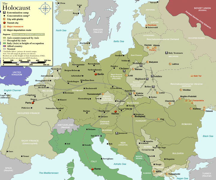
| คำอธิบาย |
Map of the Holocaust in Europe during World War II, 1939-1945.
|
| วันที่ | |
| แหล่งที่มา | Self-made by User:Dna-Dennis, using information from USHMM & Wikipedia. |
| ผู้สร้างสรรค์ | User:Dna-Dennis |
| การอนุญาต (การใช้ไฟล์นี้ใหม่) |
CC, see below. The map is completely unrestricted for any Wikipedia/Wikimedia project. |
| เวอร์ชันอื่น |
[]
|


.png)


.png)


.png)

|
ภาพนี้มีภาพในรูปแบบเวกเตอร์ (SVG)
หากภาพ SVG ทำให้การแสดงผลดีกว่า หน้าที่ใช้ภาพนี้ควรเปลี่ยนไปใช้ภาพ SVG แทน File:WW2-Holocaust-Europe.png → File:WW2 Holocaust Europe map-fr.svg
สำหรับข้อมูลเพิ่มเติมเกี่ยวกับภาพเวกเตอร์ ดูที่ การเปลี่ยนไปใช้ภาพ SVG ในคอมมอนส์ นอกจากนี้สามารถดูเพิ่มเติมเกี่ยวกับ ข้อมูลเกี่ยวกับการรองรับภาพ SVG สำหรับซอฟต์แวร์มีเดียวิกิ ได้ |
 |
การอนุญาตใช้สิทธิ
- คุณสามารถ:
- ที่จะแบ่งปัน – ที่จะทำสำเนา แจกจ่าย และส่งงานดังกล่าวต่อไป
- ที่จะเรียบเรียงใหม่ – ที่จะดัดแปลงงานดังกล่าว
- ภายใต้เงื่อนไขต่อไปนี้:
- แสดงที่มา – คุณต้องให้เกียรติเจ้าของงานอย่างเหมาะสม โดยเพิ่มลิงก์ไปยังสัญญาอนุญาต และระบุหากมีการเปลี่ยนแปลง คุณอาจทำเช่นนี้ได้ในรูปแบบใดก็ได้ตามควร แต่ต้องไม่ใช่ในลักษณะที่แนะว่าผู้ให้อนุญาตสนับสนุนคุณหรือการใช้งานของคุณ
ประวัติไฟล์
คลิกวันที่/เวลาเพื่อดูไฟล์ที่ปรากฏในขณะนั้น
| วันที่/เวลา | รูปย่อ | ขนาด | ผู้ใช้ | ความเห็น | |
|---|---|---|---|---|---|
| ปัจจุบัน | 20:57, 29 ตุลาคม 2552 | | 1,310 × 1,090 (639 กิโลไบต์) | Flying Saucer | moved Vaivara to it's right place |
| 10:41, 20 ธันวาคม 2550 |  | 1,310 × 1,090 (826 กิโลไบต์) | Dna-webmaster~commonswiki | new version without "Axis cooperating" in legend | |
| 09:00, 20 ธันวาคม 2550 |  | 1,310 × 1,090 (824 กิโลไบต์) | Dna-webmaster~commonswiki | Now entire West Prussia and Wartheland is included in the Third Reich | |
| 23:42, 19 ธันวาคม 2550 |  | 1,310 × 1,090 (828 กิโลไบต์) | Dna-webmaster~commonswiki | still not Da Vinci, but errors have been corrected (Germany borders West/East), West & East Prussia borders/coloring and Poland General Government corrected borders. | |
| 17:46, 17 ธันวาคม 2550 |  | 1,310 × 1,090 (825 กิโลไบต์) | Dna-webmaster~commonswiki | new map with 1942 borders, not Da Vinci, but here it goes... | |
| 20:32, 19 ตุลาคม 2550 |  | 1,310 × 1,090 (766 กิโลไบต์) | Dna-webmaster~commonswiki | and another update | |
| 19:21, 19 ตุลาคม 2550 |  | 1,310 × 1,090 (771 กิโลไบต์) | Dna-webmaster~commonswiki | quick fix | |
| 19:11, 19 ตุลาคม 2550 |  | 1,310 × 1,090 (771 กิโลไบต์) | Dna-webmaster~commonswiki | {{Information |Description=Map of the Holocaust in Europe during World War II, 1939-1945. <br> This map shows all extermination camps (or ''death camps''), most major concentration camps, work camps, prison camps, ghettos, major deportation routes and maj |
หน้าที่มีภาพนี้
ไม่มีหน้าใดโยงมาที่ภาพนี้
การใช้ไฟล์ข้ามโครงการ
วิกิอื่นต่อไปนี้ใช้ไฟล์นี้:
- การใช้บน af.wikipedia.org
- การใช้บน ar.wikipedia.org
- การใช้บน az.wikipedia.org
- การใช้บน be-tarask.wikipedia.org
- การใช้บน be.wikipedia.org
- การใช้บน bn.wikipedia.org
- การใช้บน ca.wikipedia.org
- การใช้บน cs.wikipedia.org
- การใช้บน de.wikipedia.org
- การใช้บน el.wikipedia.org
- การใช้บน en.wikipedia.org
- Auschwitz concentration camp
- Extermination camp
- Sobibor extermination camp
- Drancy internment camp
- White Buses
- Vel' d'Hiv Roundup
- Template:Image frame
- German war crimes
- René Bousquet
- Holocaust trains
- Portal:Genocide/Selected article
- Portal:Genocide/Selected article/8
- Mechelen transit camp
- User:Dna-webmaster/Projects
- Jewish ghettos in Europe
- List of Jewish ghettos in Europe during World War II
- Template:Image frame/doc
- User:Jnestorius/Resources
- Wikipedia:Featured picture candidates/January-2015
- Wikipedia:Featured picture candidates/Map of the Holocaust in Europe
- The Holocaust in Hungary
- Emigration of Jews from Nazi Germany and German-occupied Europe
- Talk:The Holocaust/Archive 31
- Template:Image frame/sandbox
- Reich Security Head Office Referat IV B4
- Genocides in history (World War I through World War II)
- User:Buidhe/fork
- การใช้บน en.wikibooks.org
- การใช้บน es.wikipedia.org
- การใช้บน et.wikipedia.org
- การใช้บน fa.wikipedia.org
- การใช้บน fi.wikipedia.org
ดูการใช้ข้ามโครงการเพิ่มเติมของไฟล์นี้