ไฟล์:Vancouver1798map-SanJuan-Gulf.png
ขนาดของตัวอย่างนี้: 521 × 599 พิกเซล ความละเอียดอื่น: 209 × 240 พิกเซล | 417 × 480 พิกเซล | 766 × 881 พิกเซล
ดูภาพที่มีความละเอียดสูงกว่า (766 × 881 พิกเซล, ขนาดไฟล์: 1.39 เมกะไบต์, ชนิดไมม์: image/png)
| รูปภาพหรือไฟล์เสียงนี้ ต้นฉบับอยู่ที่ คอมมอนส์ รายละเอียดด้านล่าง เป็นข้อความที่แสดงผลจาก ไฟล์ต้นฉบับในคอมมอนส์
|
ความย่อ
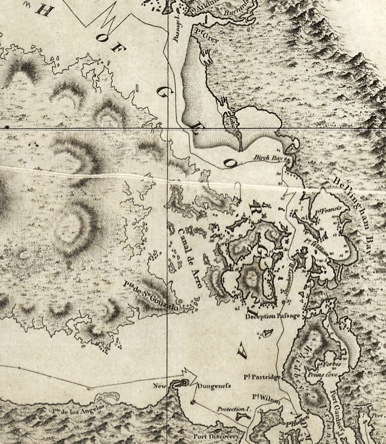
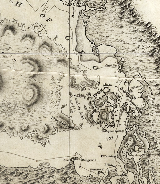
| คำอธิบาย | Excerpt of a map by George Vancouver, titled "A chart shewing part of the coast of N.W. America : with the tracks of His Majesty's sloop Discovery and armed tender Chatham / commanded by George Vancouver, Esqr. and prepared under his immediate inspection by Lieut. Joseph Baker..."; published 1798 |
| วันที่ | |
| แหล่งที่มา | http://hdl.loc.gov/loc.gmd/g3512c.ct000914 |
| ผู้สร้างสรรค์ | George Vancouver; digital version, Library of Congress, Geography and Map Division. |
| การอนุญาต (การใช้ไฟล์นี้ใหม่) |
"The Library of Congress is providing access to these materials for educational and research purposes and is not aware of any U.S. copyright protection" (source: [1]) |
การอนุญาตใช้สิทธิ
งานนี้เป็น สาธารณสมบัติ ในประเทศสหรัฐอเมริกา เนื่องจากเป็นงานของรัฐบาลกลางสหรัฐอเมริกา ทั้งนี้ ตามความของมาตรา 105 หมวด 1 ลักษณะ 17 แห่งประมวลกฎหมายสหรัฐอเมริกา ดูเพิ่มที่ ลิขสิทธิ์
หมายเหตุ ข้อความข้างต้นใช้บังคับแก่งานของรัฐบาลกลางสหรัฐอเมริกาเท่านั้น งานของรัฐใด ๆ ในสหรัฐอเมริกา ดินแดน เครือจักรภพ เทศมณฑล เทศบาล หรือองค์กรปกครองส่วนท้องถิ่นอื่นใด ไม่ถึอเป็นงานที่เป็นสาธารณสมบัติตามประมวลกฎหมายนี้ นอกจากนี้ แม่แบบนี้ไม่ใช้กับตราไปรษณียากรแบบใด ๆ ที่กรมไปรษณีย์แห่งสหรัฐอเมริกา นำออกใช้ตั้งแต่ ค.ศ. 1978 (พ.ศ. 2521) เป็นต้นมา ซึ่งมีลิขสิทธิ์และไม่เป็นสาธารณสมบัติ (ดูรายละเอียดที่ ระเบียบแห่งสำนักงานลิขสิทธิ์ บทย่อที่ 2 ข้อ 206.02 (b))
|
 | |
| ไฟล์นี้ได้ถูกระบุว่าไม่มีข้อจำกัดภายใต้กฎหมายลิขสิทธิ์ รวมถึงสิทธิที่เกี่ยวข้องและที่ใกล้เคียงกัน | ||

|
This map is available from the United States Library of Congress's Geography & Map Division
under the digital ID ct000914 g3512c ct000914. This tag does not indicate the copyright status of the attached work. A normal copyright tag is still required. See Commons:Licensing.
|
ประวัติไฟล์
คลิกวันที่/เวลาเพื่อดูไฟล์ที่ปรากฏในขณะนั้น
| วันที่/เวลา | รูปย่อ | ขนาด | ผู้ใช้ | ความเห็น | |
|---|---|---|---|---|---|
| ปัจจุบัน | 13:42, 16 พฤษภาคม 2551 | | 766 × 881 (1.39 เมกะไบต์) | Pfly | {{Information |Description=Excerpt of a map by George Vancouver, titled "A chart shewing part of the coast of N.W. America : with the tracks of His Majesty's sloop Discovery and armed tender Chatham / commanded by George Vancouver, Esqr. and prepared unde |
หน้าที่มีภาพนี้
หน้าต่อไปนี้ โยงมาที่ภาพนี้:
การใช้ไฟล์ข้ามโครงการ
วิกิอื่นต่อไปนี้ใช้ไฟล์นี้:
- การใช้บน en.wikipedia.org
- การใช้บน he.wikipedia.org
- การใช้บน hy.wikipedia.org
- การใช้บน ja.wikipedia.org
- การใช้บน no.wikipedia.org
- การใช้บน ro.wikipedia.org
- การใช้บน ru.wikipedia.org
- การใช้บน uk.wikipedia.org