ไฟล์:St helens map showing 1980 eruption deposits.png
ไม่มีภาพที่มีรายละเอียดสูงกว่านี้
St_helens_map_showing_1980_eruption_deposits.png (702 × 527 พิกเซล, ขนาดไฟล์: 18 กิโลไบต์, ชนิดไมม์: image/png)
| รูปภาพหรือไฟล์เสียงนี้ ต้นฉบับอยู่ที่ คอมมอนส์ รายละเอียดด้านล่าง เป็นข้อความที่แสดงผลจาก ไฟล์ต้นฉบับในคอมมอนส์
|
ความย่อ
| คำอธิบาย | |
| แหล่งที่มา | USGS |
| ผู้สร้างสรรค์ | USGS |

|
ภาพธรณีวิทยานี้ ควรจะถูกสร้างใหม่เป็นกราฟิกส์เวกเตอร์ ซึ่งมีข้อดีอีกหลายประการ ดูเพิ่มเติมที่คอมมอนส์:สื่อต้องการเก็บกวาดสำหรับสารสนเทศเพิ่มเติม หากภาพนี้มีในรูปแบบกราฟิกส์เวกเตอร์อยู่แล้ว กรุณาอัปโหลดและแทนที่แม่แบบนี้ด้วย
{{vector version available|ชื่อภาพใหม่}}
แนะนำเป็นอย่างยิ่งให้ตั้งชื่อไฟล์เวกเตอร์ใหม่นั้นในรูปแบบ "St helens map showing 1980 eruption deposits.svg" แล้วใส่แม่แบบ Vector version available (หรือ Vva) ซึ่งไม่ต้องใช้พารามิเตอร์ ชื่อภาพใหม่ |
การอนุญาตใช้สิทธิ
This image is in the public domain in the United States because it only contains materials that originally came from the United States Geological Survey, an agency of the United States Department of the Interior. For more information, see the official USGS copyright policy.
|
บันทึกการอัพโหลด
The original description page was here. All following user names refer to en.wikipedia.
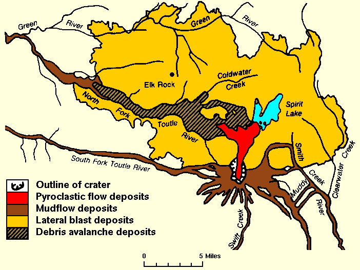
- 2007-12-27 01:18 Peteforsyth 702×527× (17938 bytes) replacing jpeg version, and cropping out extraneous text. Map of the area around Mount St. Helens which were affected by the May 18, 1980 eruption. North is to the top. [[USGS]] image from [http://vulcan.wr.usgs.gov/Volcanoes/MSH/SlideSet/ljt_slideset_
ประวัติไฟล์
คลิกวันที่/เวลาเพื่อดูไฟล์ที่ปรากฏในขณะนั้น
| วันที่/เวลา | รูปย่อ | ขนาด | ผู้ใช้ | ความเห็น | |
|---|---|---|---|---|---|
| ปัจจุบัน | 01:18, 25 พฤษภาคม 2554 | | 702 × 527 (18 กิโลไบต์) | File Upload Bot (Magnus Manske) | {{BotMoveToCommons|en.wikipedia|year={{subst:CURRENTYEAR}}|month={{subst:CURRENTMONTHNAME}}|day={{subst:CURRENTDAY}}}} {{Information |Description={{en|replacing jpeg version, and cropping out extraneous text. Map of the area around Mount St. Helens whic |
หน้าที่มีภาพนี้
หน้าต่อไปนี้ โยงมาที่ภาพนี้:
การใช้ไฟล์ข้ามโครงการ
วิกิอื่นต่อไปนี้ใช้ไฟล์นี้:
- การใช้บน bg.wikipedia.org
- การใช้บน cs.wikipedia.org
- การใช้บน el.wikipedia.org
- การใช้บน en.wikipedia.org
- การใช้บน fa.wikipedia.org
- การใช้บน id.wikipedia.org
- การใช้บน km.wikipedia.org
- การใช้บน mk.wikipedia.org
- การใช้บน ms.wikipedia.org
- การใช้บน ne.wikipedia.org
- การใช้บน nl.wikipedia.org
- การใช้บน pt.wikipedia.org
- การใช้บน simple.wikipedia.org
- การใช้บน sr.wikipedia.org
- การใช้บน te.wikipedia.org
- การใช้บน tr.wikipedia.org
- การใช้บน uk.wikipedia.org
- การใช้บน uz.wikipedia.org
- การใช้บน vi.wikipedia.org
- การใช้บน zh.wikipedia.org