ไฟล์:Snowfield Peak 8648s.JPG

ขนาดของตัวอย่างนี้: 800 × 450 พิกเซล ความละเอียดอื่น: 320 × 180 พิกเซล | 640 × 360 พิกเซล | 1,024 × 576 พิกเซล | 1,280 × 720 พิกเซล | 2,560 × 1,441 พิกเซล | 6,892 × 3,879 พิกเซล
ดูภาพที่มีความละเอียดสูงกว่า (6,892 × 3,879 พิกเซล, ขนาดไฟล์: 8.78 เมกะไบต์, ชนิดไมม์: image/jpeg)
| รูปภาพหรือไฟล์เสียงนี้ ต้นฉบับอยู่ที่ คอมมอนส์ รายละเอียดด้านล่าง เป็นข้อความที่แสดงผลจาก ไฟล์ต้นฉบับในคอมมอนส์
|
ความย่อ
| คำอธิบาย |
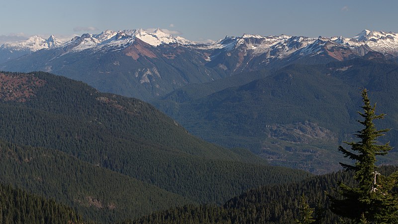
English: View across the Skagit River Valley of the northern portion of the south unit of North Cascades National Park: Snowfield Peak (left center skyline with cloud behind); The Needle (skyline, left of cloud); Big Devil Peak (middle distance); The Trapezoid (middle distance, centered below small cloud); Paul Bunyans Stump (skyline with shadowed north face); Pinnacle Peak (left skyline); Primus Peak (right skyline above Tsuga mertensiana in foreground; Little Devil Peak (middle distance skyline, left of Primus Peak)
|
| วันที่ | 28 ตุลาคม พ.ศ. 2556, 20:09:19 +00:00 |
| แหล่งที่มา | งานของตัว |
| ผู้สร้างสรรค์ | Walter Siegmund (talk) |
| เวอร์ชันอื่น |
|


| ตำแหน่งที่ตั้งกล้อง | | ภาพนี้และภาพอื่น ๆ ณ สถานที่เดียวกันที่ OpenStreetMap |
|---|
| Camera Model | Canon EOS DIGITAL REBEL XSi |
|---|---|
| Shutter speed | 1/200 |
| Aperture | f/11.0 |
| Film speed (ISO) | 400 |
| Focal length | 100.0 |
| Filter(s) | Hoya Circular Polarizer, HOCPMC67 |

|
This image is the work of Walter Siegmund
|
การอนุญาตใช้สิทธิ
ข้าพเจ้า ในฐานะผู้ถือลิขสิทธิ์ของภาพหรือสื่อนี้ อนุญาตให้ใช้ภาพหรือสื่อนี้ภายใต้เงื่อนไขต่อไปนี้
ไฟล์นี้อยู่ภายใต้สัญญาอนุญาต ครีเอทีฟคอมมอนส์ แบบแสดงที่มา-อนุญาตแบบเดียวกัน 3.0 ต้นฉบับ
- คุณสามารถ:
- ที่จะแบ่งปัน – ที่จะทำสำเนา แจกจ่าย และส่งงานดังกล่าวต่อไป
- ที่จะเรียบเรียงใหม่ – ที่จะดัดแปลงงานดังกล่าว
- ภายใต้เงื่อนไขต่อไปนี้:
- แสดงที่มา – คุณต้องให้เกียรติเจ้าของงานอย่างเหมาะสม โดยเพิ่มลิงก์ไปยังสัญญาอนุญาต และระบุหากมีการเปลี่ยนแปลง คุณอาจทำเช่นนี้ได้ในรูปแบบใดก็ได้ตามควร แต่ต้องไม่ใช่ในลักษณะที่แนะว่าผู้ให้อนุญาตสนับสนุนคุณหรือการใช้งานของคุณ
- อนุญาตแบบเดียวกัน – หากคุณดัดแปลง เปลี่ยนรูป หรือต่อเติมงานนี้ คุณต้องใช้สัญญาอนุญาตแบบเดียวกันหรือแบบที่เหมือนกับสัญญาอนุญาตที่ใช้กับงานนี้เท่านั้น
ประวัติไฟล์
คลิกวันที่/เวลาเพื่อดูไฟล์ที่ปรากฏในขณะนั้น
| วันที่/เวลา | รูปย่อ | ขนาด | ผู้ใช้ | ความเห็น | |
|---|---|---|---|---|---|
| ปัจจุบัน | 05:03, 15 มกราคม 2558 | | 6,892 × 3,879 (8.78 เมกะไบต์) | Wsiegmund |
หน้าที่มีภาพนี้
หน้าต่อไปนี้ โยงมาที่ภาพนี้:
การใช้ไฟล์ข้ามโครงการ
วิกิอื่นต่อไปนี้ใช้ไฟล์นี้: