ไฟล์:Satellite image of Bangladesh in October 2001.jpg

ขนาดของตัวอย่างนี้: 554 × 599 พิกเซล ความละเอียดอื่น: 222 × 240 พิกเซล | 444 × 480 พิกเซล | 710 × 768 พิกเซล | 947 × 1,024 พิกเซล | 2,214 × 2,394 พิกเซล
ดูภาพที่มีความละเอียดสูงกว่า (2,214 × 2,394 พิกเซล, ขนาดไฟล์: 674 กิโลไบต์, ชนิดไมม์: image/jpeg)
| รูปภาพหรือไฟล์เสียงนี้ ต้นฉบับอยู่ที่ คอมมอนส์ รายละเอียดด้านล่าง เป็นข้อความที่แสดงผลจาก ไฟล์ต้นฉบับในคอมมอนส์
|
| คำอธิบาย |
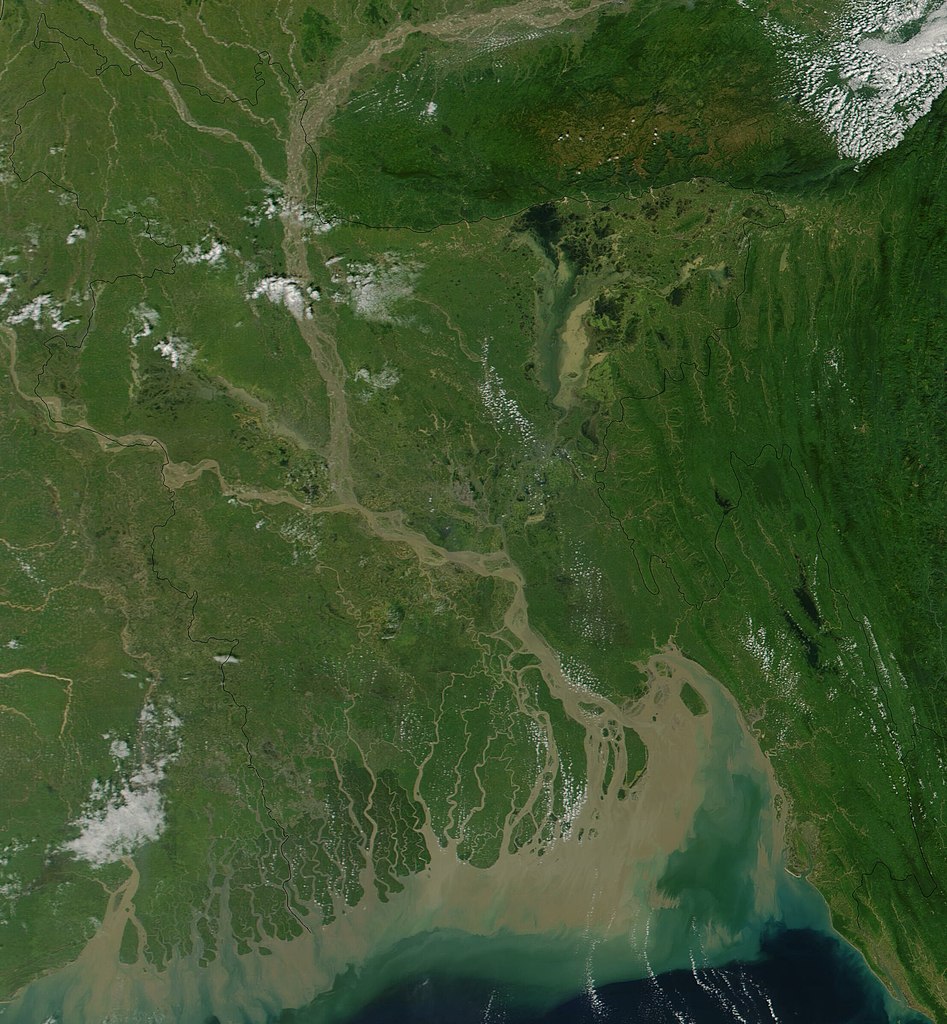
Satellite image of Bangladesh in October 2001 True-color MODIS image from October 23, 2001. Lush with vegetation to the south, numerous rivers, brown with churned up sediment, flow into the valley of the Brahmaputra River in Assam, India. The Brahmaputra turns southward at the border of Bangladesh and is soon joined by the Ganges River, flowing in from image left. The mighty river splits into numerous channels as it runs out toward the Bay of Bengal, giving the region the name "Mouths of the Ganges." Vast amounts of sediment are being emptied into the Bay by the river, and greenish blue swirls could be a mixture of sediment and phytoplankton. |
| วันที่ | |
| แหล่งที่มา | Cropped from Visible Earth |
| ผู้สร้างสรรค์ | Jacques Descloitres, MODIS Land Rapid Response Team, NASA/GSFC |
| ภาพนี้เป็นสาธารณสมบัติ เนื่องจากเป็นภาพที่สร้างขึ้นโดยองค์การบริหารการบินและอวกาศแห่งชาติ (NASA) ซึ่งตามนโยบายด้านลิขสิทธิ์ของนาซาระบุไว้ว่า "ภาพและสื่อต่าง ๆ ของนาซาไม่ได้รับการคุ้มครองโดยลิขสิทธิ์ยกเว้นจะระบุไว้ว่ามีลิขสิทธิ์" ดูเพิ่มที่ หน้านโยบายด้านลิขสิทธิ์ของนาซา หรือ นโยบายการใช้ภาพของ JPL | ||
 |
คำเตือน:
|
ประวัติไฟล์
คลิกวันที่/เวลาเพื่อดูไฟล์ที่ปรากฏในขณะนั้น
| วันที่/เวลา | รูปย่อ | ขนาด | ผู้ใช้ | ความเห็น | |
|---|---|---|---|---|---|
| ปัจจุบัน | 22:38, 18 ธันวาคม 2547 | | 2,214 × 2,394 (674 กิโลไบต์) | Hautala | {{PD-USGov-NASA}} Satellite image of Bangladesh in October 2001. Original image taken from NASA's Visible Earth http://visibleearth.nasa.gov/cgi-bin/viewrecord?10722 |
หน้าที่มีภาพนี้
หน้าต่อไปนี้ โยงมาที่ภาพนี้:
การใช้ไฟล์ข้ามโครงการ
วิกิอื่นต่อไปนี้ใช้ไฟล์นี้:
- การใช้บน af.wikipedia.org
- การใช้บน ar.wikipedia.org
- การใช้บน ast.wikipedia.org
- การใช้บน as.wikipedia.org
- การใช้บน ba.wikipedia.org
- การใช้บน be-tarask.wikipedia.org
- การใช้บน bg.wikipedia.org
- การใช้บน bm.wikipedia.org
- การใช้บน bn.wikipedia.org
- การใช้บน bs.wikipedia.org
- การใช้บน ca.wikipedia.org
- การใช้บน cs.wikipedia.org
- การใช้บน de.wikipedia.org
- การใช้บน en.wikipedia.org
- การใช้บน en.wikiquote.org
- การใช้บน es.wikipedia.org
- การใช้บน fi.wikipedia.org
- การใช้บน frr.wikipedia.org
- การใช้บน id.wikipedia.org
- การใช้บน it.wikipedia.org
- การใช้บน jv.wikipedia.org
- การใช้บน lt.wikipedia.org
- การใช้บน new.wikipedia.org
- การใช้บน nl.wikipedia.org
- การใช้บน no.wikipedia.org
- การใช้บน pl.wikipedia.org
- การใช้บน pt.wikipedia.org
- การใช้บน roa-tara.wikipedia.org
- การใช้บน ru.wikipedia.org
- การใช้บน sh.wikipedia.org
- การใช้บน sr.wikipedia.org
- การใช้บน ta.wikipedia.org
- การใช้บน te.wikipedia.org
- การใช้บน tg.wikipedia.org
- การใช้บน uk.wikipedia.org
- การใช้บน vi.wikipedia.org
ดูการใช้ข้ามโครงการเพิ่มเติมของไฟล์นี้