ไฟล์:Periplous of the Erythraean Sea.svg

ขนาดของตัวอย่าง PNG นี้ของไฟล์ SVG นี้: 800 × 564 พิกเซล ความละเอียดอื่น: 320 × 226 พิกเซล | 640 × 452 พิกเซล | 1,024 × 722 พิกเซล | 1,280 × 903 พิกเซล | 2,560 × 1,806 พิกเซล
ดูภาพที่มีความละเอียดสูงกว่า ((ไฟล์ SVG, 1,280 × 903 พิกเซล, ขนาดไฟล์: 1.39 เมกะไบต์))
| รูปภาพหรือไฟล์เสียงนี้ ต้นฉบับอยู่ที่ คอมมอนส์ รายละเอียดด้านล่าง เป็นข้อความที่แสดงผลจาก ไฟล์ต้นฉบับในคอมมอนส์
|
ความย่อ
| คำอธิบาย |
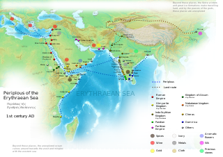
English: Periplous of the Erythreaen Sea map, according to the description from source text (https://el.wikisource.org/wiki/Περίπλους_τῆς_Ἐρυθράς_Θαλάσσης). Original names have been transcribed to Latin alphabet when possible. For the Greek names look at the respective Greek version of the map.
Ελληνικά: Χάρτης του περίπλου της Ερυθράς Θαλάσσης(Αγγλική έκδοση), σύμφωνα με την περιγραφή του κειμένου (https://el.wikisource.org/wiki/Περίπλους_τῆς_Ἐρυθράς_Θαλάσσης). हिन्दी: एरिथ्रेअन सागर के पेरिप्लस के नाम, मार्ग और स्थान
Català: Mapa del Periple de la Mar Eritrea, segons la descripció de la font (https://el.wikisource.org/wiki/Περίπλους_τῆς_Ἐρυθράς_Θαλάσσης). Els noms originals s'han transcrit a l'alfabet llatí quan ha estat possible. Per als noms grecs mireu la versió grega del mapa. |
| วันที่ | |
| แหล่งที่มา | งานของตัว |
| ผู้สร้างสรรค์ | George Tsiagalakis |
| การอนุญาต (การใช้ไฟล์นี้ใหม่) |
Mention author and licence when using this work, e.g. "George Tsiagalakis / CC-BY-SA-4 licence" |
| เวอร์ชันอื่น |
|


ไฟล์ภาพกราฟิกส์เวกเตอร์ไม่ได้ระบุการตรวจโดย W3C นี้ สร้างขึ้นโดยใช้ Inkscape .

|
ไฟล์ SVG นี้มีข้อความที่สามารถแปลได้ โดยใช้เครื่องมือแปบภาษา SVG หรือใช้ตัวแก้ไข SVG ใดก็ได้ สำหรับข้อมูลเพิ่มเติม ดูที่เกี่ยวกับการแปลไฟล์ |
การอนุญาตใช้สิทธิ
ข้าพเจ้า ในฐานะผู้ถือลิขสิทธิ์ของภาพหรือสื่อนี้ อนุญาตให้ใช้ภาพหรือสื่อนี้ภายใต้เงื่อนไขต่อไปนี้
| Multi-licensed with all versions of the Creative Commons Attribution Share-Alike License | ||
| I agree to multi-license my contributions, unless otherwise stated, under the GFDL and the Creative Commons Attribution Share-Alike license version 1.0, version 2.0, version 2.5, version 3.0, and all future versions of the Creative Commons Attribution Share-Alike license. Please be aware that other contributors might not do the same, so if you want to use my contributions under the Creative Commons terms, please check the CC dual-license and Multi-licensing guides. | ||

|
อนุญาตให้คัดลอก แจกจ่ายและ/หรือดัดแปรเอกสารนี้ภายใต้เงื่อนไขของสัญญาอนุญาตเอกสารเสรีของกนู รุ่น 1.2 หรือรุ่นใด ๆ นับจากนี้ที่ออกโดยมูลนิธิซอฟต์แวร์เสรี โดยไม่มีส่วนใดห้ามแก้ไข ไม่มีข้อความปกหน้าและปกหลัง สำเนาของสัญญาอนุญาตรวมอยู่ในส่วนชื่อ สัญญาอนุญาตเอกสารเสรีของกนู |
This file is licensed under the Creative Commons Attribution-Share Alike 4.0 International, 3.0 Unported, 2.5 Generic, 2.0 Generic and 1.0 Generic license.
- คุณสามารถ:
- ที่จะแบ่งปัน – ที่จะทำสำเนา แจกจ่าย และส่งงานดังกล่าวต่อไป
- ที่จะเรียบเรียงใหม่ – ที่จะดัดแปลงงานดังกล่าว
- ภายใต้เงื่อนไขต่อไปนี้:
- แสดงที่มา – คุณต้องให้เกียรติเจ้าของงานอย่างเหมาะสม โดยเพิ่มลิงก์ไปยังสัญญาอนุญาต และระบุหากมีการเปลี่ยนแปลง คุณอาจทำเช่นนี้ได้ในรูปแบบใดก็ได้ตามควร แต่ต้องไม่ใช่ในลักษณะที่แนะว่าผู้ให้อนุญาตสนับสนุนคุณหรือการใช้งานของคุณ
- อนุญาตแบบเดียวกัน – หากคุณดัดแปลง เปลี่ยนรูป หรือต่อเติมงานนี้ คุณต้องใช้สัญญาอนุญาตแบบเดียวกันหรือแบบที่เหมือนกับสัญญาอนุญาตที่ใช้กับงานนี้เท่านั้น
ประวัติไฟล์
คลิกวันที่/เวลาเพื่อดูไฟล์ที่ปรากฏในขณะนั้น
| วันที่/เวลา | รูปย่อ | ขนาด | ผู้ใช้ | ความเห็น | |
|---|---|---|---|---|---|
| ปัจจุบัน | 00:48, 30 กันยายน 2566 | | 1,280 × 903 (1.39 เมกะไบต์) | Joutbis | File uploaded using svgtranslate tool (https://svgtranslate.toolforge.org/). Added translation for ca. |
| 00:33, 30 กันยายน 2566 |  | 1,280 × 903 (1.38 เมกะไบต์) | Joutbis | File uploaded using svgtranslate tool (https://svgtranslate.toolforge.org/). Added translation for ca. | |
| 04:13, 2 กุมภาพันธ์ 2566 |  | 1,280 × 903 (1.32 เมกะไบต์) | Theklan | File uploaded using svgtranslate tool (https://svgtranslate.toolforge.org/). Added translation for eu. | |
| 02:12, 10 มกราคม 2565 |  | 1,280 × 903 (1.28 เมกะไบต์) | Mr. Ibrahem | Reverted to version as of 11:44, 6 May 2021 (UTC) | |
| 20:29, 9 มกราคม 2565 |  | 1,280 × 903 (1.28 เมกะไบต์) | Mr. Ibrahem | File uploaded using svgtranslate tool (https://svgtranslate.toolforge.org/). Added translation for ar. | |
| 18:44, 6 พฤษภาคม 2564 |  | 1,280 × 903 (1.28 เมกะไบต์) | Andrei Stroe | File uploaded using svgtranslate tool (https://svgtranslate.toolforge.org/). Added translation for ro. | |
| 23:10, 31 มกราคม 2558 |  | 1,280 × 903 (1.28 เมกะไบต์) | Gts-tg | Small updates in spelling of city names | |
| 22:39, 31 มกราคม 2558 |  | 1,280 × 903 (1.28 เมกะไบต์) | Gts-tg | More accurate positioning for Nikon(os) and Sarapion(os), corresponding to modern Barawe and Mogadishu respectively. Improved legibility of place names | |
| 10:15, 29 มกราคม 2558 |  | 1,280 × 903 (1.28 เมกะไบต์) | Gts-tg | Updates as [https://en.wikipedia.org/wiki/User_talk:Gts-tg#Periplus_svg indicated by Wikipedia editors] | |
| 00:31, 27 ธันวาคม 2557 |  | 1,280 × 903 (1.28 เมกะไบต์) | Gts-tg | User created page with UploadWizard |
หน้าที่มีภาพนี้
ไม่มีหน้าใดโยงมาที่ภาพนี้
การใช้ไฟล์ข้ามโครงการ
วิกิอื่นต่อไปนี้ใช้ไฟล์นี้:
- การใช้บน af.wikipedia.org
- การใช้บน ar.wikipedia.org
- การใช้บน arz.wikipedia.org
- การใช้บน az.wikipedia.org
- การใช้บน bg.wikipedia.org
- การใช้บน bn.wikipedia.org
- การใช้บน ca.wikipedia.org
- การใช้บน ceb.wikipedia.org
- การใช้บน cs.wikipedia.org
- การใช้บน da.wikipedia.org
- การใช้บน de.wikipedia.org
- การใช้บน el.wikipedia.org
- การใช้บน en.wikipedia.org
- Arabian Sea
- History of Cambodia
- Foreign relations of Ethiopia
- Red Sea
- Kozhikode
- Kochi
- Malappuram district
- Tamils
- Roman Egypt
- Spice trade
- Trade route
- Bharuch
- History of South India
- Kollam
- Barbarikon
- Hippalus
- Islam in India
- Opone
- Mappila Muslims
- Sino-Roman relations
- Christianity in India
- Timeline of international trade
ดูการใช้ข้ามโครงการเพิ่มเติมของไฟล์นี้