ไฟล์:Netherlands with provinces.png
ไม่มีภาพที่มีรายละเอียดสูงกว่านี้
Netherlands_with_provinces.png (200 × 235 พิกเซล, ขนาดไฟล์: 23 กิโลไบต์, ชนิดไมม์: image/png)
| รูปภาพหรือไฟล์เสียงนี้ ต้นฉบับอยู่ที่ คอมมอนส์ รายละเอียดด้านล่าง เป็นข้อความที่แสดงผลจาก ไฟล์ต้นฉบับในคอมมอนส์
|
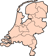
Description: Map of the Netherlands, with provinces. Description: Map for localisazion of the province of Friesland in the Netherlands.
Clickable version


|
อนุญาตให้คัดลอก แจกจ่ายและ/หรือดัดแปรเอกสารนี้ภายใต้เงื่อนไขของสัญญาอนุญาตเอกสารเสรีของกนู รุ่น 1.2 หรือรุ่นใด ๆ นับจากนี้ที่ออกโดยมูลนิธิซอฟต์แวร์เสรี โดยไม่มีส่วนใดห้ามแก้ไข ไม่มีข้อความปกหน้าและปกหลัง สำเนาของสัญญาอนุญาตรวมอยู่ในส่วนชื่อ สัญญาอนุญาตเอกสารเสรีของกนู |
| ไฟล์นี้อยู่ภายใต้สัญญาอนุญาต ครีเอทีฟคอมมอนส์ แบบแสดงที่มา-อนุญาตแบบเดียวกัน 3.0 ต้นฉบับ | ||
| ||
| ป้ายแสดงสถานะลิขสิทธิ์นี้ถูกเพิ่มเพื่อให้เป็นไปตามการเปลี่ยนแปลงสัญญาอนุญาตของมูลนิธิวิกิมีเดีย จาก GFDL ไปยัง GFDL ควบคู่กับ CC-BY-SA 3.0 |
| Annotations | This image is annotated: View the annotations at Commons |


ประวัติไฟล์
คลิกวันที่/เวลาเพื่อดูไฟล์ที่ปรากฏในขณะนั้น
| วันที่/เวลา | รูปย่อ | ขนาด | ผู้ใช้ | ความเห็น | |
|---|---|---|---|---|---|
| ปัจจุบัน | 20:59, 30 กรกฎาคม 2548 | | 200 × 235 (23 กิโลไบต์) | J.Hollemans~commonswiki | '''Description:''' Map of the Netherlands, with provinces. {{GFDL}} Category:Maps of Netherlands |
หน้าที่มีภาพนี้
หน้าต่อไปนี้ โยงมาที่ภาพนี้:
การใช้ไฟล์ข้ามโครงการ
วิกิอื่นต่อไปนี้ใช้ไฟล์นี้:
- การใช้บน af.wikipedia.org
- การใช้บน an.wikipedia.org
- การใช้บน br.wikipedia.org
- การใช้บน ce.wikipedia.org
- การใช้บน da.wikipedia.org
- Leiden
- Haag
- Amsterdam
- Rotterdam
- Eindhoven
- Groningen
- Utrecht
- Wikipedia:Skabeloner/Geografi
- Enschede
- Nijmegen
- Hengelo
- Tilburg
- Waalwijk
- Maastricht
- Noord-Holland
- Gelderland
- Groningen (provins)
- Schiermonnikoog
- Ameland
- Leeuwarden
- Harlingen
- Zuid-Holland
- Zeeland
- Borne
- Noord-Brabant
- Limburg (nederlandsk provins)
- Bonaire
- Terschelling
- Haarlem
- Frisland (Nederlandene)
- Zeist
- Vlaardingen
- Delft
- Arnhem
- Leek
- Overijssel
- Saba (Caribien)
- Skabelon:Nederlandske provinser
- Wijchen
- Drenthe
- Flevoland
- Utrecht (provins)
ดูการใช้ข้ามโครงการเพิ่มเติมของไฟล์นี้