ไฟล์:Neer-Mahal.jpg
Neer-Mahal.jpg (511 × 285 พิกเซล, ขนาดไฟล์: 78 กิโลไบต์, ชนิดไมม์: image/jpeg)
| รูปภาพหรือไฟล์เสียงนี้ ต้นฉบับอยู่ที่ คอมมอนส์ รายละเอียดด้านล่าง เป็นข้อความที่แสดงผลจาก ไฟล์ต้นฉบับในคอมมอนส์
|
ความย่อ
| คำอธิบาย |
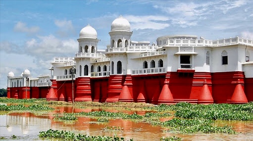
English: Neermahal (meaning "Water Palace") is a beautiful historical place which was built by 90 years ago the former royal King Bir Bikram Kishore Manikya Bahadur of the erstwhile Kingdom of Tripura, Neer-Mahal in the middle of the lake Rudrasagar in 1930 and was completed by 1938. It is situated in Melaghar, 53 kilometers away from Agartala, the capital of Tripura. The palace is situated in the middle of Rudrasagar Lake and assimilates Hindu and Muslim architectural styles.Now a days it is popularly known as tourists sport in every festival of different communities people visit there.
বাংলা: নীরমহল |
| วันที่ | |
| แหล่งที่มา | งานของตัว |
| ผู้สร้างสรรค์ | Babulmiah12 |
| ตำแหน่งที่ตั้งกล้อง | | ภาพนี้และภาพอื่น ๆ ณ สถานที่เดียวกันที่ OpenStreetMap |
|---|
The palace is the largest of its kind in India and the only one in Eastern India. There are only two water palace in India another one is the Jal Mahal in Rajasthan.
Known as ‘lake palace’ of Tripura,Rajghat .Neer-Mahal was constructed as a summer residence for king of Tripura.It was Maharaja Bir Bikram Manikya Bahadur’s idea to build a palace in the beautiful Rudrasagar lake and in 1921 he accredited the British company Martin and Burns to construct the palace for him. The company took nine years to complete the work. Maharaja Bir Bikram Manikya Bahadur belonged to the ‘Manikya Dynasty’ which is supposed to be the second from a single line in the world today.
การอนุญาตใช้สิทธิ
- คุณสามารถ:
- ที่จะแบ่งปัน – ที่จะทำสำเนา แจกจ่าย และส่งงานดังกล่าวต่อไป
- ที่จะเรียบเรียงใหม่ – ที่จะดัดแปลงงานดังกล่าว
- ภายใต้เงื่อนไขต่อไปนี้:
- แสดงที่มา – คุณต้องให้เกียรติเจ้าของงานอย่างเหมาะสม โดยเพิ่มลิงก์ไปยังสัญญาอนุญาต และระบุหากมีการเปลี่ยนแปลง คุณอาจทำเช่นนี้ได้ในรูปแบบใดก็ได้ตามควร แต่ต้องไม่ใช่ในลักษณะที่แนะว่าผู้ให้อนุญาตสนับสนุนคุณหรือการใช้งานของคุณ
- อนุญาตแบบเดียวกัน – หากคุณดัดแปลง เปลี่ยนรูป หรือต่อเติมงานนี้ คุณต้องใช้สัญญาอนุญาตแบบเดียวกันหรือแบบที่เหมือนกับสัญญาอนุญาตที่ใช้กับงานนี้เท่านั้น

|
ภาพถ่ายนี้อัปโหลดมาโดยเป็นส่วนหนึ่งของการประกวดภาพถ่าย Wiki Loves Monuments 2018.
|
 |
ประวัติไฟล์
คลิกวันที่/เวลาเพื่อดูไฟล์ที่ปรากฏในขณะนั้น
| วันที่/เวลา | รูปย่อ | ขนาด | ผู้ใช้ | ความเห็น | |
|---|---|---|---|---|---|
| ปัจจุบัน | 12:47, 1 กันยายน 2561 | | 511 × 285 (78 กิโลไบต์) | Babulmiah12 | User created page with UploadWizard |
หน้าที่มีภาพนี้
หน้าต่อไปนี้ โยงมาที่ภาพนี้:
การใช้ไฟล์ข้ามโครงการ
วิกิอื่นต่อไปนี้ใช้ไฟล์นี้:
- การใช้บน as.wikipedia.org
- การใช้บน bcl.wikipedia.org
- การใช้บน bn.wikipedia.org
- การใช้บน en.wikipedia.org
- การใช้บน es.wikipedia.org
- การใช้บน gu.wikipedia.org
- การใช้บน mni.wikipedia.org
- การใช้บน mr.wikipedia.org
- การใช้บน my.wikipedia.org
- การใช้บน sat.wikipedia.org
- การใช้บน simple.wikipedia.org
- การใช้บน te.wikipedia.org
- การใช้บน tr.wikipedia.org
- การใช้บน ur.wikipedia.org