ไฟล์:Map of current Interstates.svg

ขนาดของตัวอย่าง PNG นี้ของไฟล์ SVG นี้: 689 × 432 พิกเซล ความละเอียดอื่น: 320 × 201 พิกเซล | 640 × 401 พิกเซล | 1,024 × 642 พิกเซล | 1,280 × 803 พิกเซล | 2,560 × 1,605 พิกเซล
ดูภาพที่มีความละเอียดสูงกว่า ((ไฟล์ SVG, 689 × 432 พิกเซล, ขนาดไฟล์: 518 กิโลไบต์))
| รูปภาพหรือไฟล์เสียงนี้ ต้นฉบับอยู่ที่ คอมมอนส์ รายละเอียดด้านล่าง เป็นข้อความที่แสดงผลจาก ไฟล์ต้นฉบับในคอมมอนส์
|

|
This file requires updating because: Multiple Interstates and future Interstate are Missing In doing so, you could add a timestamp to the file.
|
ความย่อ
| คำอธิบาย |
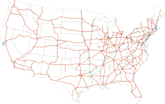
Labels:
One or Two-digit interstates (dark orange line)
Selected three-digit interstates (blue line)
Selected planned interstates (green dashed line) |
| วันที่ | |
| แหล่งที่มา | National Atlas |
| ผู้สร้างสรรค์ | SPUI |
การอนุญาตใช้สิทธิ
| งานนี้ได้ถูกเผยแพร่สู่สาธารณสมบัติโดยเจ้าของ SPUI ซึ่งมีผลทั่วโลก ในบางประเทศ การกระทำดังกล่าวอาจไม่สามารถทำได้ตามกฎหมาย |
| Annotations | This image is annotated: View the annotations at Commons |
ประวัติไฟล์
คลิกวันที่/เวลาเพื่อดูไฟล์ที่ปรากฏในขณะนั้น
| วันที่/เวลา | รูปย่อ | ขนาด | ผู้ใช้ | ความเห็น | |
|---|---|---|---|---|---|
| ปัจจุบัน | 18:19, 13 กุมภาพันธ์ 2556 | | 689 × 432 (518 กิโลไบต์) | Scott5114 | Add I-49 in Missouri |
| 13:39, 11 มกราคม 2556 |  | 689 × 432 (519 กิโลไบต์) | Agricolae | add I-376 rebranding north to I-80, planned I-99 from I-80 to I-86 | |
| 14:27, 2 กรกฎาคม 2554 |  | 689 × 432 (485 กิโลไบต์) | Jkirkuslamont | Changed hues to improve legibility for the colour blind | |
| 11:36, 10 มกราคม 2553 |  | 689 × 432 (754 กิโลไบต์) | Techman224 | Made three-dight Interstates near Atlanta, Georgia blue | |
| 04:32, 24 ธันวาคม 2552 |  | 689 × 432 (754 กิโลไบต์) | Clorox | added I69 | |
| 13:12, 29 กุมภาพันธ์ 2551 |  | 689 × 432 (744 กิโลไบต์) | Alex43223 | Updated a couple highways | |
| 09:38, 22 มิถุนายน 2550 |  | 689 × 432 (687 กิโลไบต์) | Fran Rogers | Reverted to earlier revision | |
| 09:37, 22 มิถุนายน 2550 |  | 689 × 432 (687 กิโลไบต์) | Fran Rogers | {{spuimap}} Map of the present Interstate Highway System. Base map is [http://www.nationalatlas.gov/printable/images/pdf/reference/genref.pdf] (public domain US Federal Government). *Purple: two-digit *Blue: selected three-digit *Green: selected future ro | |
| 23:07, 13 กรกฎาคม 2549 |  | 689 × 432 (687 กิโลไบต์) | SPUI~commonswiki | {{spuimap}} |
หน้าที่มีภาพนี้
หน้าต่อไปนี้ โยงมาที่ภาพนี้:
การใช้ไฟล์ข้ามโครงการ
วิกิอื่นต่อไปนี้ใช้ไฟล์นี้:
- การใช้บน an.wikipedia.org
- การใช้บน ar.wikipedia.org
- การใช้บน ast.wikipedia.org
- การใช้บน az.wikipedia.org
- การใช้บน bg.wikipedia.org
- การใช้บน bs.wikipedia.org
- การใช้บน ca.wikipedia.org
- การใช้บน da.wikipedia.org
- การใช้บน de.wikipedia.org
- การใช้บน en.wikipedia.org
- Economy of the United States
- Transportation in the United States
- List of gaps in Interstate Highways
- List of auxiliary Interstate Highways
- Controlled-access highway
- List of business routes of the Interstate Highway System
- User:Master son/US Roads
- User:Master son/US Roads/MTF
- Driving in the United States
- Trucking industry in the United States
- 1956 in the United States
- List of transport megaprojects
- User:Stephen100002/sandbox
- User:Vigneshdm1990/sandbox
- User:44Nifty/sandbox
- User:XanUltra
- Transportation policy of the United States
- Talk:United States/Archive 102
- Portal:Transport/Highway media
- Wikipedia talk:External links/Archive 42
- Wikipedia:Village pump (technical)/Archive 208
- การใช้บน en.wikibooks.org
- การใช้บน eo.wikipedia.org
- การใช้บน es.wikipedia.org
- การใช้บน et.wikipedia.org
- การใช้บน eu.wikipedia.org
- การใช้บน fa.wikipedia.org
- การใช้บน fi.wikipedia.org
ดูการใช้ข้ามโครงการเพิ่มเติมของไฟล์นี้