ไฟล์:Map of California NA.png
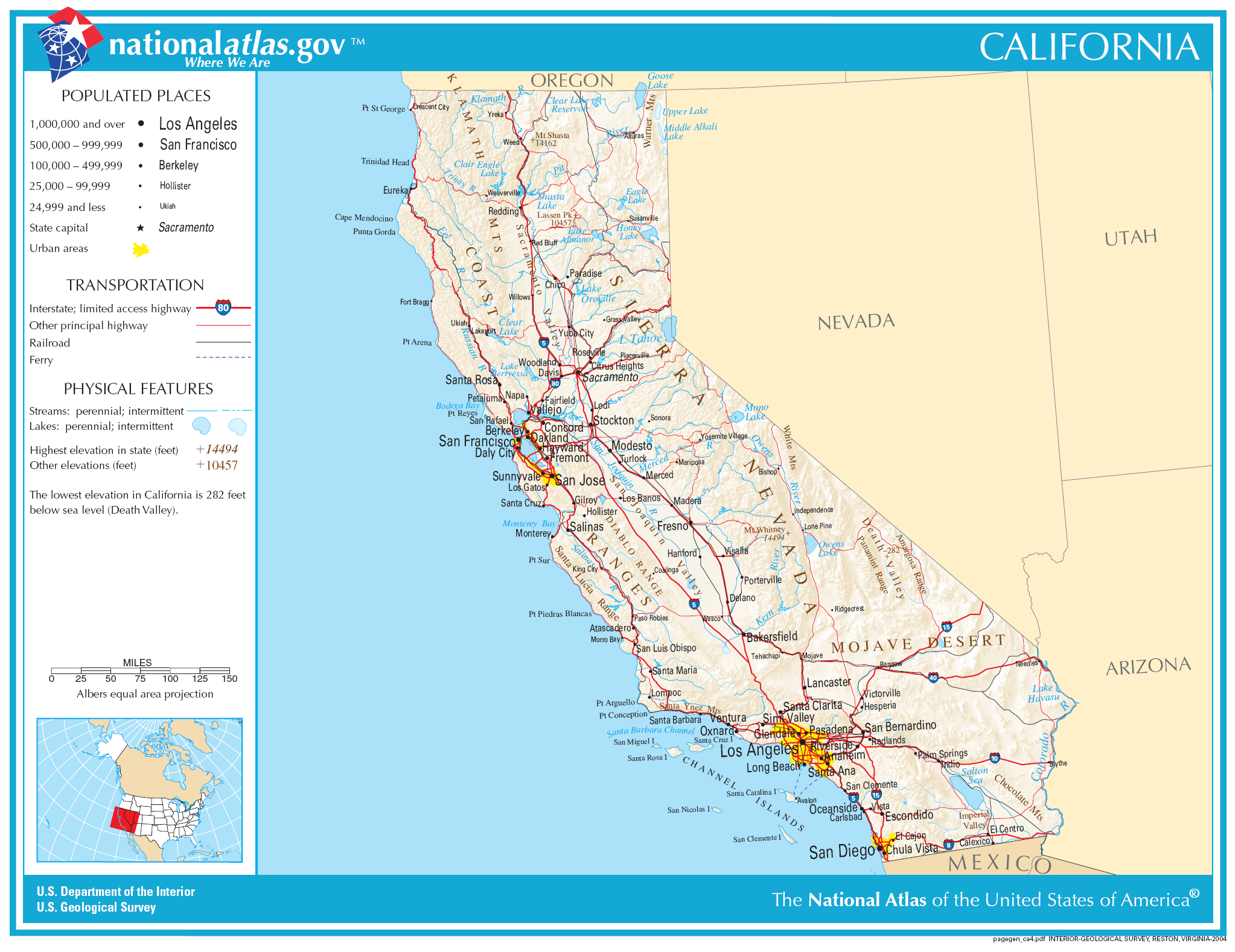
ขนาดของตัวอย่างนี้: 777 × 600 พิกเซล ความละเอียดอื่น: 311 × 240 พิกเซล | 622 × 480 พิกเซล | 995 × 768 พิกเซล | 1,280 × 988 พิกเซล | 2,046 × 1,579 พิกเซล
ดูภาพที่มีความละเอียดสูงกว่า (2,046 × 1,579 พิกเซล, ขนาดไฟล์: 1.48 เมกะไบต์, ชนิดไมม์: image/png)
| รูปภาพหรือไฟล์เสียงนี้ ต้นฉบับอยู่ที่ คอมมอนส์ รายละเอียดด้านล่าง เป็นข้อความที่แสดงผลจาก ไฟล์ต้นฉบับในคอมมอนส์
|
ความย่อ
| คำอธิบาย | |
| วันที่ | |
| แหล่งที่มา | |
| ผู้สร้างสรรค์ | National Atlas of the United States |
| การอนุญาต (การใช้ไฟล์นี้ใหม่) |
Public domain |
การอนุญาตใช้สิทธิ
This map was obtained from an edition of the National Atlas of the United States. Like almost all works of the U.S. federal government, works from the National Atlas are in the public domain in the United States.
Online access: NationalAtlas.gov | 1970 print edition: Library of Congress, Perry-Castañeda Library
|
ประวัติไฟล์
คลิกวันที่/เวลาเพื่อดูไฟล์ที่ปรากฏในขณะนั้น
| วันที่/เวลา | รูปย่อ | ขนาด | ผู้ใช้ | ความเห็น | |
|---|---|---|---|---|---|
| ปัจจุบัน | 13:34, 30 พฤศจิกายน 2549 | | 2,046 × 1,579 (1.48 เมกะไบต์) | Jengod | Crop to reduce excess whitespace on border |
| 03:19, 15 สิงหาคม 2549 |  | 2,122 × 1,640 (1.55 เมกะไบต์) | Huebi~commonswiki | {{Information| |Description=Map of Valifornia |Source=[http://www.nationalatlas.gov National Atlas] }} Category:Maps of the United States Category:Maps of California {{PD-USGov-Atlas}} |
หน้าที่มีภาพนี้
หน้าต่อไปนี้ โยงมาที่ภาพนี้:
การใช้ไฟล์ข้ามโครงการ
วิกิอื่นต่อไปนี้ใช้ไฟล์นี้:
- การใช้บน als.wikipedia.org
- การใช้บน be-tarask.wikipedia.org
- การใช้บน bh.wikipedia.org
- การใช้บน ca.wikipedia.org
- การใช้บน de.wikipedia.org
- การใช้บน en.wikipedia.org
- การใช้บน eo.wikipedia.org
- การใช้บน fa.wikipedia.org
- การใช้บน fo.wikipedia.org
- การใช้บน hi.wikipedia.org
- การใช้บน hsb.wikipedia.org
- การใช้บน hu.wikipedia.org
- การใช้บน id.wikipedia.org
- การใช้บน ilo.wikipedia.org
- การใช้บน incubator.wikimedia.org
- การใช้บน it.wikipedia.org
- การใช้บน ja.wikipedia.org
ดูการใช้ข้ามโครงการเพิ่มเติมของไฟล์นี้