ไฟล์:Irene Aug 24 2011 1810Z.jpg

ดูภาพที่มีความละเอียดสูงกว่า (6,400 × 8,200 พิกเซล, ขนาดไฟล์: 25.48 เมกะไบต์, ชนิดไมม์: image/jpeg)
| รูปภาพหรือไฟล์เสียงนี้ ต้นฉบับอยู่ที่ คอมมอนส์ รายละเอียดด้านล่าง เป็นข้อความที่แสดงผลจาก ไฟล์ต้นฉบับในคอมมอนส์
|
| Warning | The original file is very high-resolution. It might not load properly or could cause your browser to freeze when opened at full size. |
|---|
ความย่อ
| คำอธิบาย |
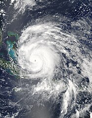
English: Hurricane Irene strengthened on its path toward the continental United States in late August 2011. Residents of the U.S. East Coast braced for the first hurricane to seriously threaten the country in three years, Voice of America reported.
The Moderate Resolution Imaging Spectroradiometer (MODIS) on NASA’s Aqua satellite captured this natural-color image at 2:15 p.m. local time (18:15 UTC) on August 24. Storm clouds hide the Turks and Caicos Islands, and extend westward over The Bahamas. Clouds also linger over the Dominican Republic and Haiti. At 2:00 p.m. Eastern Daylight Time on August 24, about the time MODIS took this picture, the U.S. National Hurricane Center (NHC) reported that Irene was a Category 3 hurricane with maximum sustained winds of 120 miles (195 kilometers) per hour. By 5:00 a.m. EDT on August 25, the NHC reported, Irene’s winds had weakened slightly, to 115 miles (185 kilometers) per hour. The storm remained a powerful Category 3 hurricane. A hurricane warning was in effect for the southeastern, central, and northwestern Bahamas. A hurricane watch was in effect for Surf City, North Carolina, northward to the Virginia border. A tropical storm watch was in effect for Edisto Beach, South Carolina, north to Surf City. As of 5:00 a.m. EDT on August 25, Irene was moving toward the northwest at about 12 miles (19 kilometers) per hour. The storm was expected to turn toward the north-northwest the same day, then toward the north early the following day. The NHC five-day storm track showed Irene moving northward along the U.S. East Coast. As U.S. residents braced for Irene’s arrival, residents of Caribbean Islands cleaned up from the destructive storm. The Christian Science Monitor reported that flooding and mudslides had forced the Dominican Republic to evacuate nearly 38,000 people, and a U.S.-based analysis firm estimated potential damage in the Caribbean at up to $3.1 billion. |
| วันที่ | |
| แหล่งที่มา | http://earthobservatory.nasa.gov/NaturalHazards/view.php?id=51867 |
| ผู้สร้างสรรค์ | NASA image courtesy Jeff Schmaltz, MODIS Rapid Response, NASA Goddard Space Flight Center. Caption by Michon Scott. |
การอนุญาตใช้สิทธิ
| ภาพนี้เป็นสาธารณสมบัติ เนื่องจากเป็นภาพที่สร้างขึ้นโดยองค์การบริหารการบินและอวกาศแห่งชาติ (NASA) ซึ่งตามนโยบายด้านลิขสิทธิ์ของนาซาระบุไว้ว่า "ภาพและสื่อต่าง ๆ ของนาซาไม่ได้รับการคุ้มครองโดยลิขสิทธิ์ยกเว้นจะระบุไว้ว่ามีลิขสิทธิ์" ดูเพิ่มที่ หน้านโยบายด้านลิขสิทธิ์ของนาซา หรือ นโยบายการใช้ภาพของ JPL | ||
 |
คำเตือน:
|
ประวัติไฟล์
คลิกวันที่/เวลาเพื่อดูไฟล์ที่ปรากฏในขณะนั้น
| วันที่/เวลา | รูปย่อ | ขนาด | ผู้ใช้ | ความเห็น | |
|---|---|---|---|---|---|
| ปัจจุบัน | 13:49, 29 ตุลาคม 2562 | | 6,400 × 8,200 (25.48 เมกะไบต์) | Nino Marakot | Reverted to version as of 22:50, 29 July 2013 (UTC) - Reverting to final re-upload by Supportstorm |
| 06:26, 16 เมษายน 2561 |  | 8,232 × 9,737 (55.25 เมกะไบต์) | MarioProtIV | Reverted to version as of 02:33, 14 November 2012 (UTC) | |
| 06:07, 30 มีนาคม 2561 |  | 1,400 × 1,700 (402 กิโลไบต์) | CooperScience | Centering image | |
| 05:50, 30 กรกฎาคม 2556 |  | 6,400 × 8,200 (25.48 เมกะไบต์) | Supportstorm | Gallery version | |
| 09:33, 14 พฤศจิกายน 2555 |  | 8,232 × 9,737 (55.25 เมกะไบต์) | Supportstorm | HDF File Quality Image | |
| 04:36, 25 สิงหาคม 2554 |  | 6,620 × 6,620 (6.45 เมกะไบต์) | Supportstorm | {{Information |Description ={{en|1=Major Hurricane Irene on August 24, 2011 as a category three.}} |Source =http://lance-modis.eosdis.nasa.gov/wms/?zoom=3&lat=21.75&lon=-16.18359&layers=000B0FFFFFFT&datum1=08/24/2011 |Author =NASA, MODI |
หน้าที่มีภาพนี้
หน้าต่อไปนี้ โยงมาที่ภาพนี้:
การใช้ไฟล์ข้ามโครงการ
วิกิอื่นต่อไปนี้ใช้ไฟล์นี้:
- การใช้บน ar.wikipedia.org
- การใช้บน de.wikipedia.org
- การใช้บน en.wikipedia.org
- การใช้บน eo.wikipedia.org
- การใช้บน es.wikipedia.org
- การใช้บน es.wikinews.org
- การใช้บน eu.wikipedia.org
- การใช้บน fa.wikipedia.org
- การใช้บน fi.wikipedia.org
- การใช้บน fr.wikipedia.org
- การใช้บน hi.wikipedia.org
- การใช้บน id.wikipedia.org
- การใช้บน is.wikipedia.org
- การใช้บน it.wikipedia.org
- การใช้บน ja.wikipedia.org
- การใช้บน jv.wikipedia.org
- การใช้บน ko.wikipedia.org
- การใช้บน ms.wikipedia.org
- การใช้บน nl.wikipedia.org
- การใช้บน pl.wikipedia.org
- การใช้บน pt.wikipedia.org
- การใช้บน ro.wikipedia.org
- การใช้บน ru.wikipedia.org
- การใช้บน ru.wikinews.org
- การใช้บน simple.wikipedia.org
- การใช้บน ta.wikipedia.org
- การใช้บน uk.wikipedia.org
- การใช้บน vi.wikipedia.org
- การใช้บน www.wikidata.org
- การใช้บน zh.wikipedia.org