ไฟล์:Holy Roman Empire 1648.svg

ขนาดของตัวอย่าง PNG นี้ของไฟล์ SVG นี้: 756 × 599 พิกเซล ความละเอียดอื่น: 303 × 240 พิกเซล | 606 × 480 พิกเซล | 969 × 768 พิกเซล | 1,280 × 1,015 พิกเซล | 2,560 × 2,030 พิกเซล | 2,283 × 1,810 พิกเซล
ดูภาพที่มีความละเอียดสูงกว่า ((ไฟล์ SVG, 2,283 × 1,810 พิกเซล, ขนาดไฟล์: 3.07 เมกะไบต์))
| รูปภาพหรือไฟล์เสียงนี้ ต้นฉบับอยู่ที่ คอมมอนส์ รายละเอียดด้านล่าง เป็นข้อความที่แสดงผลจาก ไฟล์ต้นฉบับในคอมมอนส์
|
ความย่อ
| คำอธิบาย |
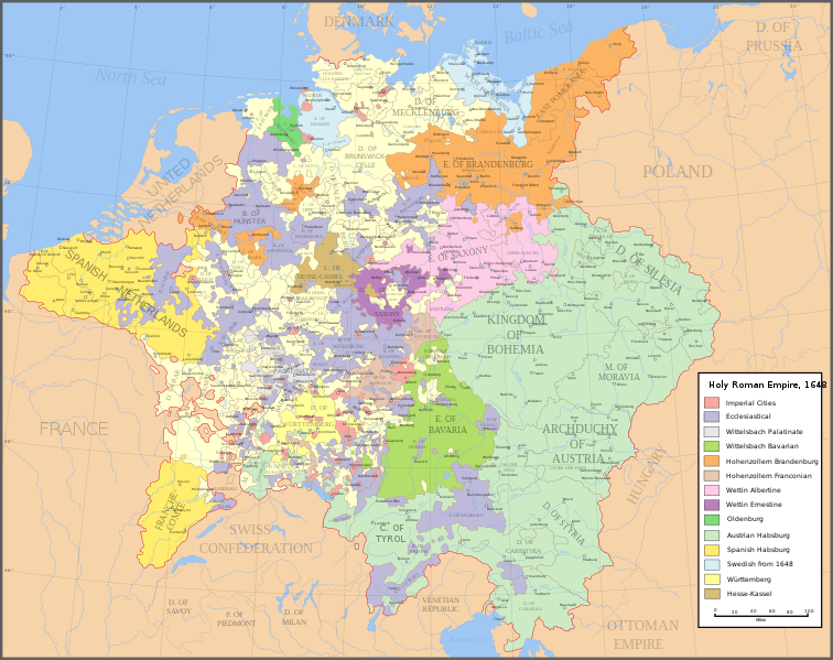
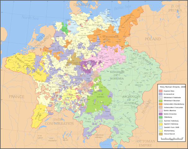
English: Map of the Holy Roman Empire in 1648, after the Peace of Westphalia which ended the Thirty Years' War. Deutsch: Karte des Heiligen Römischen Reiches 1648, nach dem Westfälischer Friede, der den Dreißigjähriger Krieg beendete. Français : Carte du Saint-Empire à 1648, après la paix de Westphalie qui mettent fin à la guerre de Trente Ans. Version française est disponible à File:Holy Roman Empire 1648 fr.svg. Српски / srpski: Мапа Светог римског царства у 1648, након Вестфалског мира којим је завршен Тридесетогодишњи рат.
|
English | Deutsch | Français | Српски |
||
|---|---|---|---|---|---|
| A | Archbishopric | Erzbistum | Archevêché | АДИЈ. | Архидијецеза |
| B | Bishopric | Bistum | Évêché | ДИЈ. | Дијецеза |
| C | County | Grafschaft | Comté | ОКР./ГРОФ. | Округ/грофовија |
| D | Duchy | Herzogtum | Duché | ВОЈВ. | Војводство |
| E | Electorate | Kurfürstentum | Électorat | ЕЛЕКТ. | Електорат |
| L | Landgraviate | Landgrafschaft | Landgraviat | ЛГРОФ. | Ландгрофовија |
| M | Margraviate | Markgrafschaft | Margraviat | МГРОФ. | Маркгрофовија |
| P | Principality | Fürstentum | Principauté | ГРОФ./ОКР. | Грофовија/округ |
Legend / Farblegende / Légende / Легенда
English | Deutsch | Français | Српски |
|
|---|---|---|---|---|
Palatinat des Wittelsbach |
||||
Wittelsbach Bavaria |
Wittelsbacher Bayern |
Bavière des Wittelsbach |
Вителсбах, баварски | |
Hohenzollern Franconia |
Hohenzollerner Franken |
Хоенцолерн, франконски | ||
Wettin Ernestine Saxony |
Wettiner Ernestiner Sachsen |
Saxe de la branche ernestine des Wettin |
Ветин, ернестински | |
Made from the public domain map "Central Europe about 1648" from the Historical Atlas by William R. Shepherd, at the Perry-Castañeda Library Map Collection at the University of Texas. Further information from Overy, Richard, 2006, The Times Complete history of the world Times Books ISBN 0007181299, and from this map
See also other maps at external links:
- Central Europe 1648
- Map on personal site, Europe in 1648
- Treaty of Westphalia
- 1648 map of Prussia
- Britannica, Spanish domains in 1648
ไฟล์ภาพกราฟิกส์เวกเตอร์ไม่ได้ระบุการตรวจโดย W3C นี้ สร้างขึ้นโดยใช้ Inkscape .
(การใช้ไฟล์นี้ใหม่)

|
อนุญาตให้คัดลอก แจกจ่ายและ/หรือดัดแปรเอกสารนี้ภายใต้เงื่อนไขของสัญญาอนุญาตเอกสารเสรีของกนู รุ่น 1.2 หรือรุ่นใด ๆ นับจากนี้ที่ออกโดยมูลนิธิซอฟต์แวร์เสรี โดยไม่มีส่วนใดห้ามแก้ไข ไม่มีข้อความปกหน้าและปกหลัง สำเนาของสัญญาอนุญาตรวมอยู่ในส่วนชื่อ สัญญาอนุญาตเอกสารเสรีของกนู |
| ไฟล์นี้อยู่ภายใต้สัญญาอนุญาต ครีเอทีฟคอมมอนส์ แบบแสดงที่มา-อนุญาตแบบเดียวกัน 3.0 ต้นฉบับ | ||
| ||
| ป้ายแสดงสถานะลิขสิทธิ์นี้ถูกเพิ่มเพื่อให้เป็นไปตามการเปลี่ยนแปลงสัญญาอนุญาตของมูลนิธิวิกิมีเดีย จาก GFDL ไปยัง GFDL ควบคู่กับ CC-BY-SA 3.0 |
[]
-
 อังกฤษ SVG
 -
 สเปน SVG
 -
 ฝรั่งเศส SVG
 -
 จอร์เจีย SVG
 -
 เซอร์เบีย SVG
 -
 English: Blank PNG
 -
 อังกฤษ PNG
 -
 สเปน PNG
 -
 เซอร์เบีย PNG
 -
 รัสเซีย PNG


|
ไฟล์ SVG นี้มีข้อความที่สามารถแปลได้ โดยใช้เครื่องมือแปบภาษา SVG หรือใช้ตัวแก้ไข SVG ใดก็ได้ สำหรับข้อมูลเพิ่มเติม ดูที่เกี่ยวกับการแปลไฟล์ |
ประวัติไฟล์
คลิกวันที่/เวลาเพื่อดูไฟล์ที่ปรากฏในขณะนั้น
| วันที่/เวลา | รูปย่อ | ขนาด | ผู้ใช้ | ความเห็น | |
|---|---|---|---|---|---|
| ปัจจุบัน | 03:43, 25 กรกฎาคม 2565 | | 2,283 × 1,810 (3.07 เมกะไบต์) | Maproom | ZWEIBRCKEN -> ZWEIBRÜCKEN, Treves -> Trier, Liege -> Liège |
| 00:55, 19 พฤษภาคม 2565 |  | 2,283 × 1,810 (3.07 เมกะไบต์) | Maproom | Consistent, and German, spelling of "Mainz" | |
| 03:11, 26 พฤษภาคม 2564 |  | 2,283 × 1,810 (3.07 เมกะไบต์) | ElCet | added the biggest city of Upper Silesia back then | |
| 18:34, 23 มีนาคม 2561 |  | 2,283 × 1,810 (3.01 เมกะไบต์) | Valentinian | Cleanup some names including missing umlauts. Brunswick-Lüneburg -> Brunswick-Celle (see talk). Border north of Rendsburg seems slightly off to me and the situation in Holstein is rather simplified (jointly administered areas are missing). | |
| 02:09, 9 ตุลาคม 2553 |  | 2,283 × 1,810 (3.01 เมกะไบต์) | Joostik | Ravenstein as part of Cleves | |
| 02:45, 10 สิงหาคม 2552 |  | 2,283 × 1,810 (3.01 เมกะไบต์) | Ysangkok | simplify code (save as plain svg) | |
| 16:24, 14 กรกฎาคม 2552 |  | 2,283 × 1,810 (4.17 เมกะไบต์) | Roke~commonswiki | Zusmarshausen | |
| 22:16, 20 เมษายน 2550 |  | 2,283 × 1,810 (4.12 เมกะไบต์) | Roke~commonswiki | ||
| 09:04, 20 เมษายน 2550 |  | 2,283 × 1,810 (4.11 เมกะไบต์) | Roke~commonswiki | rm HRE text, darken labels | |
| 10:04, 18 เมษายน 2550 |  | 2,283 × 1,810 (4.11 เมกะไบต์) | Roke~commonswiki |
หน้าที่มีภาพนี้
ไม่มีหน้าใดโยงมาที่ภาพนี้
การใช้ไฟล์ข้ามโครงการ
วิกิอื่นต่อไปนี้ใช้ไฟล์นี้:
- การใช้บน af.wikipedia.org
- การใช้บน azb.wikipedia.org
- การใช้บน az.wikipedia.org
- การใช้บน br.wikipedia.org
- การใช้บน ca.wikipedia.org
- การใช้บน ckb.wikipedia.org
- การใช้บน cs.wikipedia.org
- การใช้บน el.wikipedia.org
- การใช้บน en.wikipedia.org
- Peace of Westphalia
- Thirty Years' War
- Germans
- Wikipedia:WikiProject Maps
- Imperial Estate
- Talk:Paul Skalich
- Treaty of Fontainebleau (1631)
- Wikipedia:Featured picture candidates/Holy Roman Empire in 1648
- Wikipedia:Featured picture candidates/May-2007
- User talk:Giano II/archive 7
- User:Luosiji/Sandbox
- User:Jammydodger/HRE
- Germany in the early modern period
- User:Zealotzuo/Sandbox
- Wikipedia talk:WikiProject Maps/Archive 5
- Territorial evolution of France
- User:Oaholroyd/sandbox
- User:JMvanDijk/Sandbox 10
- User:DyinRich/Something Else
- Aftermath of the Eighty Years' War
- การใช้บน eo.wikipedia.org
- การใช้บน et.wikipedia.org
- การใช้บน fa.wikipedia.org
- การใช้บน fi.wikipedia.org
- การใช้บน fy.wikipedia.org
- การใช้บน hu.wikipedia.org
- การใช้บน hy.wikipedia.org
- การใช้บน id.wikipedia.org
- การใช้บน it.wikipedia.org
ดูการใช้ข้ามโครงการเพิ่มเติมของไฟล์นี้