ไฟล์:2010ElectoralCartogramGott.png
ขนาดของตัวอย่างนี้: 800 × 516 พิกเซล ความละเอียดอื่น: 320 × 206 พิกเซล | 640 × 412 พิกเซล | 900 × 580 พิกเซล
ดูภาพที่มีความละเอียดสูงกว่า (900 × 580 พิกเซล, ขนาดไฟล์: 40 กิโลไบต์, ชนิดไมม์: image/png)
| รูปภาพหรือไฟล์เสียงนี้ ต้นฉบับอยู่ที่ คอมมอนส์ รายละเอียดด้านล่าง เป็นข้อความที่แสดงผลจาก ไฟล์ต้นฉบับในคอมมอนส์
|

|
ภาพแผนที่เขตเลือกตั้งนี้ ควรจะถูกสร้างใหม่เป็นกราฟิกส์เวกเตอร์ ซึ่งมีข้อดีอีกหลายประการ ดูเพิ่มเติมที่คอมมอนส์:สื่อต้องการเก็บกวาดสำหรับสารสนเทศเพิ่มเติม หากภาพนี้มีในรูปแบบกราฟิกส์เวกเตอร์อยู่แล้ว กรุณาอัปโหลดและแทนที่แม่แบบนี้ด้วย
{{vector version available|ชื่อภาพใหม่}}
แนะนำเป็นอย่างยิ่งให้ตั้งชื่อไฟล์เวกเตอร์ใหม่นั้นในรูปแบบ "2010ElectoralCartogramGott.svg" แล้วใส่แม่แบบ Vector version available (หรือ Vva) ซึ่งไม่ต้องใช้พารามิเตอร์ ชื่อภาพใหม่ |
ความย่อ
| คำอธิบาย |
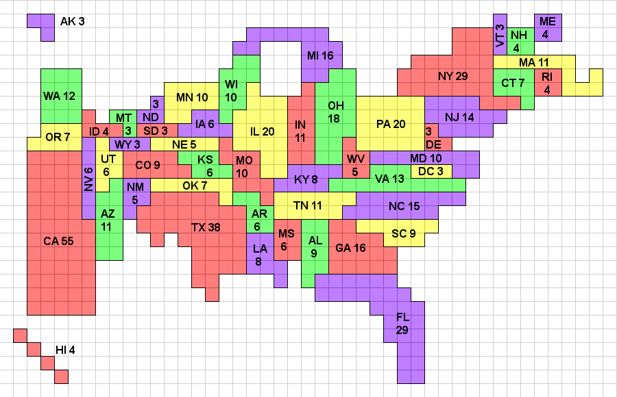
English: Gott and Colley's Electoral Cartogram showing the electoral votes apportioned to each state as a result of the 2010 Census. Note that the cartogram is topologically correct in that any state that borders another state in reality borders that state on the cartogram, and wherever multiple states meet at a point in reality, they also do so on the cartogram. The color map uses a 4-color system, which because of the topological correctness, could be applied to a standard geographic map as well. A previous version of this cartogram (reflecting the 2000 apportionment) was published in Mathematical and Computer Modeling. This image, and a monochrome version will be maintained at http://www.colleyrankings.com/cartogram2010, where one may also expect to find polling and election information in 2012. |
| วันที่ | |
| แหล่งที่มา | งานของตัว |
| ผู้สร้างสรรค์ | Wes colley |
การอนุญาตใช้สิทธิ
ข้าพเจ้า ในฐานะผู้ถือลิขสิทธิ์ของภาพหรือสื่อนี้ อนุญาตให้ใช้ภาพหรือสื่อนี้ภายใต้เงื่อนไขต่อไปนี้
ไฟล์นี้อยู่ภายใต้สัญญาอนุญาตครีเอทีฟคอมมอนส์ รุ่น แสดงที่มา 3.0 ต้นฉบับ
- คุณสามารถ:
- ที่จะแบ่งปัน – ที่จะทำสำเนา แจกจ่าย และส่งงานดังกล่าวต่อไป
- ที่จะเรียบเรียงใหม่ – ที่จะดัดแปลงงานดังกล่าว
- ภายใต้เงื่อนไขต่อไปนี้:
- แสดงที่มา – คุณต้องให้เกียรติเจ้าของงานอย่างเหมาะสม โดยเพิ่มลิงก์ไปยังสัญญาอนุญาต และระบุหากมีการเปลี่ยนแปลง คุณอาจทำเช่นนี้ได้ในรูปแบบใดก็ได้ตามควร แต่ต้องไม่ใช่ในลักษณะที่แนะว่าผู้ให้อนุญาตสนับสนุนคุณหรือการใช้งานของคุณ
ประวัติไฟล์
คลิกวันที่/เวลาเพื่อดูไฟล์ที่ปรากฏในขณะนั้น
| วันที่/เวลา | รูปย่อ | ขนาด | ผู้ใช้ | ความเห็น | |
|---|---|---|---|---|---|
| ปัจจุบัน | 02:12, 6 มกราคม 2554 | | 900 × 580 (40 กิโลไบต์) | Wes colley | Slight modification of annotations. |
| 23:59, 4 มกราคม 2554 |  | 900 × 580 (51 กิโลไบต์) | Wes colley | {{Information |Description={{en|1=Gott's Electoral Cartogram showing the electoral votes apportioned to each state as a result of the 2010 Census. Note that the cartogram is topologically correct in that any state that borders another state in reality bor |
หน้าที่มีภาพนี้
หน้าต่อไปนี้ โยงมาที่ภาพนี้:
การใช้ไฟล์ข้ามโครงการ
วิกิอื่นต่อไปนี้ใช้ไฟล์นี้:
- การใช้บน ar.wikipedia.org
- การใช้บน en.wikipedia.org
- User:Straykat99
- User:Sf46
- User:Ano-User
- User:Lawrence142002
- User:BM6
- User:Mr. Magoo and McBarker
- User:Gdeblois19
- User:Steelers3814
- User:ChangeWithUs
- User:Twitbookspacetube
- Template:User electoral college
- Template:User electoral college support
- User:Bjohnston111
- User:Chad The Goatman
- User:Burrito74
- User:Madison-1996/My Political Views
- User:Nuew
- User:LydiaCHernandez
- User:Grey ghost
- User:Invinciblewalnut
- User:InspireWithUs
- การใช้บน pt.wikipedia.org
- การใช้บน uk.wikipedia.org