ดูภาพที่มีความละเอียดสูงกว่า((ไฟล์ SVG, 750 × 550 พิกเซล, ขนาดไฟล์: 160 กิโลไบต์))

Wikimedia Commons logo รูปภาพหรือไฟล์เสียงนี้ ต้นฉบับอยู่ที่ คอมมอนส์ รายละเอียดด้านล่าง เป็นข้อความที่แสดงผลจาก ไฟล์ต้นฉบับในคอมมอนส์
คอมมอนส์เป็นเว็บไซต์ในโครงการสำหรับเก็บรวบรวมสื่อเสรี ที่ คุณสามารถช่วยได้
คำอธิบาย
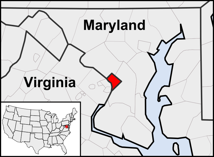
English: This is a map of the location of the District of Columbia showing the borders of states and counties around it.
วันที่ (UTC)
แหล่งที่มา
ผู้สร้างสรรค์
เวอร์ชันอื่น

ไฟล์อื่นที่ใช้ไฟล์นี้:  United States geographical collation.svg All the below are of the states (and DC) only.
Blank US map.svg Map of states
Labelled US map.svg Map with state labels
USA_blank.svg Image with Hawaii and Alaska in full size
Original blank map of USA and Canada, That image with labels
Original with Hawaii at the natural distance, That original map with labels

File:DC locator map with state names w usmap.png and File:DC locator map with state names.jpg


ภาพนี้ ได้รับการปรับแต่งภาพ ซึ่งหมายความว่าจะได้รับการเปลี่ยนแปลงภาพต่างจากต้นฉบับ การปรับปรุง: Cropping to area around District of Columbia. ต้นฉบับสามารถดูได้ที่นี่: Blank USA, w territories.svg. ปรับแต่งภาพโดย Patrickneil.

w:th:ครีเอทีฟคอมมอนส์
แสดงที่มา อนุญาตแบบเดียวกัน
คุณสามารถ:
  • ที่จะแบ่งปัน – ที่จะทำสำเนา แจกจ่าย และส่งงานดังกล่าวต่อไป
  • ที่จะเรียบเรียงใหม่ – ที่จะดัดแปลงงานดังกล่าว
ภายใต้เงื่อนไขต่อไปนี้:
  • แสดงที่มา – คุณต้องให้เกียรติเจ้าของงานอย่างเหมาะสม โดยเพิ่มลิงก์ไปยังสัญญาอนุญาต และระบุหากมีการเปลี่ยนแปลง คุณอาจทำเช่นนี้ได้ในรูปแบบใดก็ได้ตามควร แต่ต้องไม่ใช่ในลักษณะที่แนะว่าผู้ให้อนุญาตสนับสนุนคุณหรือการใช้งานของคุณ
  • อนุญาตแบบเดียวกัน – หากคุณดัดแปลง เปลี่ยนรูป หรือต่อเติมงานนี้ คุณต้องใช้สัญญาอนุญาตแบบเดียวกันหรือแบบที่เหมือนกับสัญญาอนุญาตที่ใช้กับงานนี้เท่านั้น

บันทึกการอัพโหลด

This image is a derivative work of the following images:

  • File:USA_Counties.svg licensed with PD-USGov-DOC-Census
    • 2007-12-23T15:47:48Z Lokal Profil 555x352 (2124572 Bytes) Fixed state borders and fixed the two parts of Fulton County (Kentucky)
    • 2007-12-10T02:20:23Z Lokal Profil 555x352 (2136501 Bytes) Graphical and code cleanup
    • 2007-12-10T01:15:05Z Lokal Profil 792x612 (2135690 Bytes) First stab at a code cleanup
    • 2006-08-29T00:14:37Z Petr Dlouhý 792x612 (2844548 Bytes) Original file: [[:en:Image:USA CountiesSVG.zip]] This [[ZIP (file format)|ZIP]] file contains an [[SVG]] map of the [[United States]] showing the borders of states and counties in high detail. It was derived from [http://ww
  • File:Blank_USA,_w_territories.svg licensed with Cc-by-sa-3.0-migrated, GFDL
    • 2009-01-30T01:59:59Z Hoshie 959x593 (98189 Bytes) Reverted to version as of 23:58, 14 January 2009 - rv myself; DC can be seen clearly.
    • 2009-01-18T23:34:42Z Hoshie 959x593 (102341 Bytes) Put DC in an inset; fixed Tutuila (American Samoa)
    • 2009-01-14T23:58:05Z Lokal Profil 959x593 (98189 Bytes) Code cleanup and removed stroke from Guam and American Samoa
    • 2009-01-13T05:19:51Z Hoshie 959x593 (101361 Bytes) re did Guam and added American Samoa
    • 2007-12-02T16:08:45Z Lokal Profil 959x593 (88960 Bytes) {{Information |Description=A blank map of the United States including Puerto Rico, Guam, the United States Virgin Islands, and the Northern Mariana Islands. |Source=This version was made by [[:User:Lokal_Profil|Lokal_Profil]]

Uploaded with derivativeFX

คำบรรยายโดยย่อ

เพิ่มคำบรรยายทรรทัดเดียวเพื่อขยายความว่าไฟล์นี้มีอะไร

ไอเทมที่แสดงอยู่ในไฟล์นี้

ประกอบด้วย

ประวัติไฟล์

คลิกวันที่/เวลาเพื่อดูไฟล์ที่ปรากฏในขณะนั้น

(ล่าสุด | เก่าสุด) ดู (ใหม่กว่า 10 | ) (10 | 20 | 50 | 100 | 250 | 500)
วันที่/เวลารูปย่อขนาดผู้ใช้ความเห็น
ปัจจุบัน10:23, 23 กรกฎาคม 2554รูปย่อสำหรับรุ่นเมื่อ 10:23, 23 กรกฎาคม 2554750 × 550 (160 กิโลไบต์)PatrickneilReverted to version as of 03:04, 23 July 2011
10:21, 23 กรกฎาคม 2554รูปย่อสำหรับรุ่นเมื่อ 10:21, 23 กรกฎาคม 2554750 × 550 (161 กิโลไบต์)PatrickneilReverted to version as of 03:14, 23 July 2011
10:20, 23 กรกฎาคม 2554รูปย่อสำหรับรุ่นเมื่อ 10:20, 23 กรกฎาคม 2554750 × 550 (161 กิโลไบต์)Patrickneilframe
10:14, 23 กรกฎาคม 2554รูปย่อสำหรับรุ่นเมื่อ 10:14, 23 กรกฎาคม 2554750 × 550 (161 กิโลไบต์)Patrickneilthicker frame
10:04, 23 กรกฎาคม 2554รูปย่อสำหรับรุ่นเมื่อ 10:04, 23 กรกฎาคม 2554750 × 550 (160 กิโลไบต์)Patrickneilstraightening Maryland and Delaware borders
09:09, 15 สิงหาคม 2553รูปย่อสำหรับรุ่นเมื่อ 09:09, 15 สิงหาคม 2553750 × 550 (202 กิโลไบต์)PatrickneilDelaware River again
08:51, 15 สิงหาคม 2553รูปย่อสำหรับรุ่นเมื่อ 08:51, 15 สิงหาคม 2553750 × 550 (274 กิโลไบต์)PatrickneilDelaware River border
08:42, 15 สิงหาคม 2553รูปย่อสำหรับรุ่นเมื่อ 08:42, 15 สิงหาคม 2553750 × 550 (273 กิโลไบต์)Patrickneilforgot border on Smith Island
08:34, 15 สิงหาคม 2553รูปย่อสำหรับรุ่นเมื่อ 08:34, 15 สิงหาคม 2553750 × 550 (273 กิโลไบต์)Patrickneilcounty borders below state
08:32, 15 สิงหาคม 2553รูปย่อสำหรับรุ่นเมื่อ 08:32, 15 สิงหาคม 2553750 × 550 (274 กิโลไบต์)Patrickneilchanges by request
(ล่าสุด | เก่าสุด) ดู (ใหม่กว่า 10 | ) (10 | 20 | 50 | 100 | 250 | 500)

หน้าต่อไปนี้ โยงมาที่ภาพนี้:

การใช้ไฟล์ข้ามโครงการ

วิกิอื่นต่อไปนี้ใช้ไฟล์นี้:

ดูการใช้ข้ามโครงการเพิ่มเติมของไฟล์นี้