ไฟล์:Shatt al-Basra.jpg

ดูภาพที่มีความละเอียดสูงกว่า (7,500 × 5,000 พิกเซล, ขนาดไฟล์: 19.05 เมกะไบต์, ชนิดไมม์: image/jpeg)
| รูปภาพหรือไฟล์เสียงนี้ ต้นฉบับอยู่ที่ คอมมอนส์ รายละเอียดด้านล่าง เป็นข้อความที่แสดงผลจาก ไฟล์ต้นฉบับในคอมมอนส์
|
ความย่อ
| คำอธิบาย |
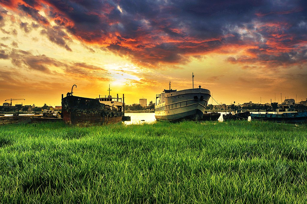
English: Shatt al-Arab was named Tigris al-Awra, a river consisting of the confluence of the Tigris and Euphrates Rivers, where the rivers meet in the region (Kerma Ali) the northern entrance to the city of Basra, while they meet in the city of Qurna, 375 km south of Baghdad. It is about 190 km long and is located in the Arabian Gulf at the edge of Al Faw city, which is the most extreme point in southern Iraq, and the Shatt al-Arab offer in some areas to 2 km. As for its flora, all were planted with palm trees before the war but were cut and neglected during the last period , And there is a beautiful city located on the banks of the Shatt al-Arab called Altnump where there are abundant palm groves and when the University of Basra was built in this city with its stunning views and charming nature and continues the river in the path until passing the Abu Al-Khasib, a region rich with palm trees, a rural area .
Until 1975, all the Shatt al-Arab waters were part of Iraq, but under the Algiers agreement, Iraq relinquished the eastern coast bordering Iran. Navigation became common. It is the intention of the local government in the city of Basra to make the island of Umm al-Rasat overlooking the Shat tourist area, but did not actually begin the completion of the project and on a related scale has expanded the talk recently about the growing phenomenon of pollution of the Shatt al-Arab water and there are speaking with experience in the field of environmental protection for the existence of Oil stains in some areas of water from the river, and the Shatt al-Arab from the deepest water bodies in Iraq, where large vessels can walk through to inside Iraq. The branch of the Shatt al-Arab River is divided into many marshes that divide the cities and the visual districts, forming one of the sweetest scenes in Basra. The local government in Basra has developed the Sayab Corniche, named after Basra poet Badr Shaker al-Sayab and Cornish Palace on the banks of the Shatt al- Occasionsالعربية: شط العرب وكان اسمه دجلة العوراء، هو نهر يتكون من التقاء نهري دجلة والفرات، حيث يلتقي النهران في منطقة (كرمة علي) المدخل الشمالي لمدينة البصرة في حين كانا يلتقيان في مدينة القرنة على بعد 375 كم جنوب بغداد. ويبلغ طوله حوالي 190 كم، ويصب في الخليج العربي عند طرف مدينة الفاو، والتي تعتبر أقصى نقطة في جنوب العراق ويصل عرض شط العرب في بعض مناطقه إلى 2 كيلو متر أما بالنسبة لضفافهِ فكانت كلها مزروعة بأشجار النخيل قبل الحرب ولكنها تعرضت للقطع والأهمال خلال الفترة الأخيرة، وهناك مدينة جميلية تقع على ضفاف شط العرب تسمى التنومة حيث تكثر فيها بساتين النخيل وعندما تم بناء جامعة البصرة كانت في هذه المدينة بما تتمع بها من مناظر خلابة وطبيعة ساحرة ويستمر النهر في المسير حتى يمر بقضاء أبي الخصيب وهي منطقة عامرة باشجار النخيل وهي منطقة ريفية.
الشجرة التين والأغنامكانت كل مياه شط العرب حتى عام 1975 جزء من العراق، الا انه وبموجب اتفاقية الجزائر تنازل العراق على الشاطيء الشرقي المطل على الحدود مع إيران لها. وأصبحت الملاحة مشتركة. وهناك نية لدى الحكومة المحلية في مدينة البصرة بأن تجعل جزيرة أم الرصاص المطلة على الشط منطقة سياحية ولكنها لم تباشر فعليا بأنجاز المشروع وعلى صعيد متصل اتسعت رقعة الحديث مؤخرا حول تفاقم ظاهرة تلوث مياه شط العرب وهناك من يتحدث من ذوي الخبرة في مجال حماية البيئة عن وجود بقع زيت في بعض المساحات المائية من النهر، ويعتبر شط العرب من أعمق المسطحات المائية في العراق حيث تستطيع السفن الكبيرة في السير من خلاله إلى داخل العراق. ويتفرع من نهر شط العرب الكثير من الأهوار التي تشق المدن والأحياء البصرية فتشكل إحدى أحلى المناظر في البصرة، ولقد طورت الحكومة المحلية في البصرة كورنيش السياب الذي سمي على اسم شاعر البصرة بدر شاكر السياب وكورنيش القصر على ضفاف شط العرب حيث يشهد حضور العديد من السائحين في المناسبات |
| วันที่ | |
| แหล่งที่มา | งานของตัว |
| ผู้สร้างสรรค์ | Mohammed Abdul Hussein |
It is the intention of the local government in the city of Basra to make the island of Umm al-Rasat overlooking the Shat tourist area, but did not actually begin the completion of the project and on a related scale has expanded the talk recently about the growing phenomenon of pollution of the Shatt al-Arab water and there are speaking with experience in the field of environmental protection for the existence of Oil stains in some areas of water from the river, and the Shatt al-Arab from the deepest water bodies in Iraq, where large vessels can walk through to inside Iraq.
การอนุญาตใช้สิทธิ
- คุณสามารถ:
- ที่จะแบ่งปัน – ที่จะทำสำเนา แจกจ่าย และส่งงานดังกล่าวต่อไป
- ที่จะเรียบเรียงใหม่ – ที่จะดัดแปลงงานดังกล่าว
- ภายใต้เงื่อนไขต่อไปนี้:
- แสดงที่มา – คุณต้องให้เกียรติเจ้าของงานอย่างเหมาะสม โดยเพิ่มลิงก์ไปยังสัญญาอนุญาต และระบุหากมีการเปลี่ยนแปลง คุณอาจทำเช่นนี้ได้ในรูปแบบใดก็ได้ตามควร แต่ต้องไม่ใช่ในลักษณะที่แนะว่าผู้ให้อนุญาตสนับสนุนคุณหรือการใช้งานของคุณ
- อนุญาตแบบเดียวกัน – หากคุณดัดแปลง เปลี่ยนรูป หรือต่อเติมงานนี้ คุณต้องใช้สัญญาอนุญาตแบบเดียวกันหรือแบบที่เหมือนกับสัญญาอนุญาตที่ใช้กับงานนี้เท่านั้น
ภาพนี้อัปโหลดเข้ามาโดยเป็นส่วนหนึ่งของ Wiki Loves Earth 2017.
|
 |
ประวัติไฟล์
คลิกวันที่/เวลาเพื่อดูไฟล์ที่ปรากฏในขณะนั้น
| วันที่/เวลา | รูปย่อ | ขนาด | ผู้ใช้ | ความเห็น | |
|---|---|---|---|---|---|
| ปัจจุบัน | 00:17, 13 พฤษภาคม 2560 | | 7,500 × 5,000 (19.05 เมกะไบต์) | Mohammed Abdul Hussein | User created page with UploadWizard |
หน้าที่มีภาพนี้
หน้าต่อไปนี้ โยงมาที่ภาพนี้:
การใช้ไฟล์ข้ามโครงการ
วิกิอื่นต่อไปนี้ใช้ไฟล์นี้:
- การใช้บน ar.wikipedia.org
- การใช้บน fi.wikipedia.org
- การใช้บน ro.wikipedia.org