ไฟล์:Serval range IUCN.svg

ขนาดของตัวอย่าง PNG นี้ของไฟล์ SVG นี้: 635 × 600 พิกเซล ความละเอียดอื่น: 254 × 240 พิกเซล | 508 × 480 พิกเซล | 813 × 768 พิกเซล | 1,084 × 1,024 พิกเซล | 2,169 × 2,048 พิกเซล | 1,525 × 1,440 พิกเซล
ดูภาพที่มีความละเอียดสูงกว่า ((ไฟล์ SVG, 1,525 × 1,440 พิกเซล, ขนาดไฟล์: 706 กิโลไบต์))
| รูปภาพหรือไฟล์เสียงนี้ ต้นฉบับอยู่ที่ คอมมอนส์ รายละเอียดด้านล่าง เป็นข้อความที่แสดงผลจาก ไฟล์ต้นฉบับในคอมมอนส์
|
ความย่อ
| คำอธิบาย |
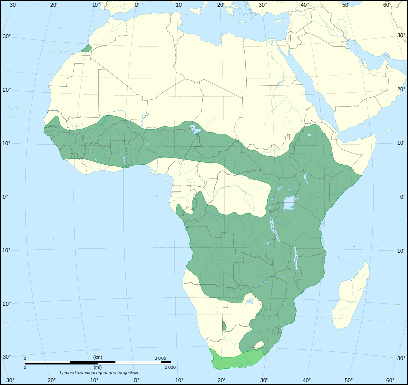
The range of Leptailurus serval, based on version sourced from IUCN Red List. |
| วันที่ | (UTC) |
| แหล่งที่มา |
This file was derived from: |
| ผู้สร้างสรรค์ |
|

| ภาพนี้ ได้รับการปรับแต่งภาพ ซึ่งหมายความว่าจะได้รับการเปลี่ยนแปลงภาพต่างจากต้นฉบับ การปรับปรุง: Redrawn as SVG on better Africa blank. ต้นฉบับสามารถดูได้ที่นี่: Africa map blank.svg. ปรับแต่งภาพโดย Odysseus1479.
|
การอนุญาตใช้สิทธิ
ไฟล์นี้อยู่ภายใต้สัญญาอนุญาต ครีเอทีฟคอมมอนส์ แบบแสดงที่มา-อนุญาตแบบเดียวกัน 3.0 ต้นฉบับ
- คุณสามารถ:
- ที่จะแบ่งปัน – ที่จะทำสำเนา แจกจ่าย และส่งงานดังกล่าวต่อไป
- ที่จะเรียบเรียงใหม่ – ที่จะดัดแปลงงานดังกล่าว
- ภายใต้เงื่อนไขต่อไปนี้:
- แสดงที่มา – คุณต้องให้เกียรติเจ้าของงานอย่างเหมาะสม โดยเพิ่มลิงก์ไปยังสัญญาอนุญาต และระบุหากมีการเปลี่ยนแปลง คุณอาจทำเช่นนี้ได้ในรูปแบบใดก็ได้ตามควร แต่ต้องไม่ใช่ในลักษณะที่แนะว่าผู้ให้อนุญาตสนับสนุนคุณหรือการใช้งานของคุณ
- อนุญาตแบบเดียวกัน – หากคุณดัดแปลง เปลี่ยนรูป หรือต่อเติมงานนี้ คุณต้องใช้สัญญาอนุญาตแบบเดียวกันหรือแบบที่เหมือนกับสัญญาอนุญาตที่ใช้กับงานนี้เท่านั้น
บันทึกการอัพโหลด
This image is a derivative work of the following images:
- File:Serval_range.png licensed with Cc-by-sa-2.5,2.0,1.0, Cc-by-sa-3.0-migrated, GFDL
- 2012-02-28T21:17:32Z Izvora 606x649 (28279 Bytes) Source http://maps.iucnredlist.org/map.html?id=11638
- 2011-12-27T11:18:12Z Schneelocke 907x955 (40507 Bytes) New map is unusable for colorblind readers. See talk page.
- 2011-07-19T02:07:48Z Craig Pemberton 344x372 (14385 Bytes) Normalize with other range maps in preparation for composite maps of higher taxa.
- 2005-12-09T22:49:27Z Laurascudder 907x955 (40507 Bytes) The range of [[leptailurus serval]]. Started from [[w: User:Brion VIBBER/Maps and images for Wikipedia|Brion VIBBER]]'s maps using information from [http://wildcat.cat-city.com/serval/map-serv.gif], [http://www.wildcatconser
- File:Africa_map_blank.svg licensed with Cc-by-sa-2.5,2.0,1.0, Cc-by-sa-3.0-migrated, GFDL
- 2011-07-14T19:50:24Z Sting 1525x1440 (698781 Bytes) Sudan/South Sudan 2011-07 border update
- 2009-01-10T20:36:44Z Sting 1525x1440 (710059 Bytes) Detail correction
- 2008-06-27T03:34:58Z Sting 1525x1440 (711453 Bytes) Completely new drawing with known projection
- 2006-05-31T15:28:42Z Sting 1390x1295 (571519 Bytes) Enhanced version : African and Asian continents separated
- 2006-05-31T03:53:32Z Sting 1390x1295 (566642 Bytes) {{Information |Description=Blank vector graphic map of [[:Category:Maps of Africa|Africa]] |Source=Several bitmap-type maps |Date= May 2006 |Author= Eric Gaba ([[User:Sting|Sting]]) |Permission=GFDL or CC-BY-SA |other_version
Uploaded with derivativeFX
ประวัติไฟล์
คลิกวันที่/เวลาเพื่อดูไฟล์ที่ปรากฏในขณะนั้น
| วันที่/เวลา | รูปย่อ | ขนาด | ผู้ใช้ | ความเห็น | |
|---|---|---|---|---|---|
| ปัจจุบัน | 09:36, 21 ตุลาคม 2555 | | 1,525 × 1,440 (706 กิโลไบต์) | Odysseus1479 | == {{int:filedesc}} == {{Information |Description=The range of ''Leptailurus serval'', based on version sourced from [http://maps.iucnredlist.org/map.html?id=11638 IUCN Red List].<br> Darker green: extant (resident). Brighter green: extinct. |Sourc... |
หน้าที่มีภาพนี้
หน้าต่อไปนี้ โยงมาที่ภาพนี้:
การใช้ไฟล์ข้ามโครงการ
วิกิอื่นต่อไปนี้ใช้ไฟล์นี้:
- การใช้บน avk.wikipedia.org
- การใช้บน en.wikipedia.org
- การใช้บน fr.wikipedia.org
- การใช้บน it.wikipedia.org
- การใช้บน kg.wikipedia.org
- การใช้บน kk.wikipedia.org
- การใช้บน ko.wikipedia.org
- การใช้บน lv.wikipedia.org
- การใช้บน mk.wikipedia.org
- การใช้บน sq.wikipedia.org
- การใช้บน tl.wikipedia.org
- การใช้บน tr.wikipedia.org
- การใช้บน uk.wikipedia.org
- การใช้บน vi.wikipedia.org