ไฟล์:Okavango River Basin map.png

ดูภาพที่มีความละเอียดสูงกว่า (3,052 × 3,160 พิกเซล, ขนาดไฟล์: 8.63 เมกะไบต์, ชนิดไมม์: image/png)
| รูปภาพหรือไฟล์เสียงนี้ ต้นฉบับอยู่ที่ คอมมอนส์ รายละเอียดด้านล่าง เป็นข้อความที่แสดงผลจาก ไฟล์ต้นฉบับในคอมมอนส์
|
ความย่อ
![]() Do not add Template:Convert to SVG, because the source is a pdf file with a pixel image, not a vector image.
Do not add Template:Convert to SVG, because the source is a pdf file with a pixel image, not a vector image.
| คำอธิบาย |
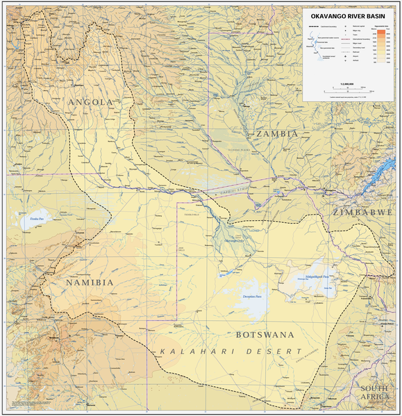
Afrikaans: Kaart van die opvangsgebied en waterskeiding (stippellyn) van die Kavangorivier in Angola, Namibië en Botswana
English: Map of the Okavango River Basin, with catchment area inside the dotted line (Angola, Namibia, Botswana) |
| วันที่ | |
| แหล่งที่มา | https://digitallibrary.un.org/record/423191?ln=en |
| ผู้สร้างสรรค์ | United Nations |
| การอนุญาต (การใช้ไฟล์นี้ใหม่) |
UN map as PD |
| เวอร์ชันอื่น |
 |
| This image is a map derived from a United Nations map.
Unless stated otherwise, UN maps are to be considered in the public domain. This applies worldwide. UN maps are, in principle, open source material and you can use them in your work or for making your own map. UN requests however that you delete the UN name, logo and reference number upon any modification to the map. Content of your map will be your responsibility. You can state in your publication, if you wish, something like: based on UN map … (map name, map number, revision number and date). See: Geospatial Information Section. And: Geospatial, location data for a better world. |
 |
ประวัติไฟล์
คลิกวันที่/เวลาเพื่อดูไฟล์ที่ปรากฏในขณะนั้น
| วันที่/เวลา | รูปย่อ | ขนาด | ผู้ใช้ | ความเห็น | |
|---|---|---|---|---|---|
| ปัจจุบัน | 21:22, 6 มกราคม 2562 | | 3,052 × 3,160 (8.63 เมกะไบต์) | JMK | adjust midtones |
| 00:09, 17 เมษายน 2551 |  | 3,052 × 3,160 (8.15 เมกะไบต์) | Foundert~commonswiki | {{Information |Description=map of the Okavango River Basin (Angola, Namibia, Botswana) |Source=http://www.un.org/Depts/Cartographic/english/htmain.htm |Date=16. April 2008 |Author=United Nations |Permission=UN map as PD |other_versions= }} {{UN map}} [[ |
หน้าที่มีภาพนี้
หน้าต่อไปนี้ โยงมาที่ภาพนี้:
การใช้ไฟล์ข้ามโครงการ
วิกิอื่นต่อไปนี้ใช้ไฟล์นี้:
- การใช้บน af.wikipedia.org
- การใช้บน ar.wikipedia.org
- การใช้บน ast.wikipedia.org
- การใช้บน avk.wikipedia.org
- การใช้บน azb.wikipedia.org
- การใช้บน bg.wikipedia.org
- การใช้บน ca.wikipedia.org
- การใช้บน cs.wikipedia.org
- การใช้บน da.wikipedia.org
- การใช้บน de.wikipedia.org
- การใช้บน el.wikipedia.org
- การใช้บน en.wikipedia.org
- การใช้บน es.wikipedia.org
- การใช้บน fi.wikipedia.org
- การใช้บน frr.wikipedia.org
- การใช้บน fr.wikipedia.org
- การใช้บน gl.wikipedia.org
- การใช้บน he.wikipedia.org
- การใช้บน hr.wikipedia.org
- การใช้บน hu.wikipedia.org
- การใช้บน id.wikipedia.org
- การใช้บน it.wikipedia.org
- การใช้บน ja.wikipedia.org
- การใช้บน ka.wikipedia.org
- การใช้บน ko.wikipedia.org
- การใช้บน lv.wikipedia.org
- การใช้บน mk.wikipedia.org
- การใช้บน ml.wikipedia.org
- การใช้บน nl.wikipedia.org
- การใช้บน oc.wikipedia.org
- การใช้บน pl.wikipedia.org
- การใช้บน pt.wikipedia.org
- การใช้บน ro.wikipedia.org
- การใช้บน sh.wikipedia.org
- การใช้บน sk.wikipedia.org
- การใช้บน sr.wikipedia.org
- การใช้บน sw.wikipedia.org
- การใช้บน ta.wikipedia.org
ดูการใช้ข้ามโครงการเพิ่มเติมของไฟล์นี้