ไฟล์:Muizz Street - Egypt.jpg

ขนาดของตัวอย่างนี้: 800 × 563 พิกเซล ความละเอียดอื่น: 320 × 225 พิกเซล | 640 × 451 พิกเซล | 1,024 × 721 พิกเซล | 1,280 × 901 พิกเซล | 2,560 × 1,802 พิกเซล | 5,682 × 4,000 พิกเซล
ดูภาพที่มีความละเอียดสูงกว่า (5,682 × 4,000 พิกเซล, ขนาดไฟล์: 18.06 เมกะไบต์, ชนิดไมม์: image/jpeg)
| รูปภาพหรือไฟล์เสียงนี้ ต้นฉบับอยู่ที่ คอมมอนส์ รายละเอียดด้านล่าง เป็นข้อความที่แสดงผลจาก ไฟล์ต้นฉบับในคอมมอนส์
|
ความย่อ
| คำอธิบาย |
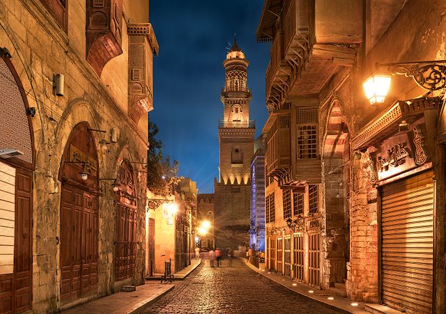
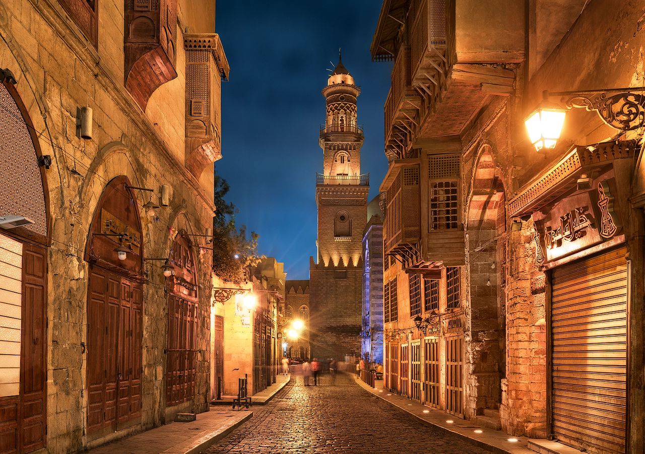
English: Old cairo between history and future.jpg Essam Azzam St. (Shariʻa al-Muizz li-Deen Illah) (30°02′ 48" N 31°15′ 36"E) in Islamic Cairo, Egypt is one of the oldest streets in Cairo, approximately one kilometer long. A United Nations study found it to have the greatest concentration of medieval architectural treasures in the Islamic world.[1] The street (shariʻa in Arabic) is named for Al-Muʿizz li-Deen Illah, the fourth caliph of the Fatimid dynasty. It stretches from Bab Al-Futuh in the north to Bab Zuweila in the south. Starting in 1997,[2][3] the national government carried out extensive renovations to the historical buildings, modern buildings, paving, and sewerage to turn the street into an "open-air museum". On April 24, 2008, Al-Muizz Street was rededicated as a pedestrian only zone between 8:00 am and 11:00 pm; cargo traffic will be allowed outside of these hours.[4]
The northern part of the street extends from the Al-Hakim Mosque in the north to the Spice Market at Al-Azhar Street and includes the antiques markets section, Al-Aqmar Mosque (one of the few extant Fatimid mosques), the Qalawun complex, and several well preserved medieval mansions and palaces. |
| วันที่ | |
| แหล่งที่มา | งานของตัว |
| ผู้สร้างสรรค์ | Mohammed Moussa |
| ตำแหน่งที่ตั้งกล้อง | | ภาพนี้และภาพอื่น ๆ ณ สถานที่เดียวกันที่ OpenStreetMap |
|---|
การอนุญาตใช้สิทธิ
ข้าพเจ้า ในฐานะผู้ถือลิขสิทธิ์ของภาพหรือสื่อนี้ อนุญาตให้ใช้ภาพหรือสื่อนี้ภายใต้เงื่อนไขต่อไปนี้
ไฟล์นี้อยู่ภายใต้สัญญาอนุญาต ครีเอทีฟคอมมอนส์ แบบแสดงที่มา-อนุญาตแบบเดียวกัน 4.0 นานาชาติ
- คุณสามารถ:
- ที่จะแบ่งปัน – ที่จะทำสำเนา แจกจ่าย และส่งงานดังกล่าวต่อไป
- ที่จะเรียบเรียงใหม่ – ที่จะดัดแปลงงานดังกล่าว
- ภายใต้เงื่อนไขต่อไปนี้:
- แสดงที่มา – คุณต้องให้เกียรติเจ้าของงานอย่างเหมาะสม โดยเพิ่มลิงก์ไปยังสัญญาอนุญาต และระบุหากมีการเปลี่ยนแปลง คุณอาจทำเช่นนี้ได้ในรูปแบบใดก็ได้ตามควร แต่ต้องไม่ใช่ในลักษณะที่แนะว่าผู้ให้อนุญาตสนับสนุนคุณหรือการใช้งานของคุณ
- อนุญาตแบบเดียวกัน – หากคุณดัดแปลง เปลี่ยนรูป หรือต่อเติมงานนี้ คุณต้องใช้สัญญาอนุญาตแบบเดียวกันหรือแบบที่เหมือนกับสัญญาอนุญาตที่ใช้กับงานนี้เท่านั้น

|
ภาพถ่ายนี้อัปโหลดมาโดยเป็นส่วนหนึ่งของการประกวดภาพถ่าย Wiki Loves Monuments 2016.
|
 |
ประวัติไฟล์
คลิกวันที่/เวลาเพื่อดูไฟล์ที่ปรากฏในขณะนั้น
| วันที่/เวลา | รูปย่อ | ขนาด | ผู้ใช้ | ความเห็น | |
|---|---|---|---|---|---|
| ปัจจุบัน | 07:13, 30 กันยายน 2559 | | 5,682 × 4,000 (18.06 เมกะไบต์) | M mousa 86 | User created page with UploadWizard |
หน้าที่มีภาพนี้
หน้าต่อไปนี้ โยงมาที่ภาพนี้:
การใช้ไฟล์ข้ามโครงการ
วิกิอื่นต่อไปนี้ใช้ไฟล์นี้:
- การใช้บน ar.wikipedia.org
- การใช้บน azb.wikipedia.org
- การใช้บน bcl.wikipedia.org
- การใช้บน bs.wikipedia.org
- การใช้บน csb.wikipedia.org
- การใช้บน el.wikipedia.org
- การใช้บน en.wikipedia.org
- การใช้บน et.wikipedia.org
- การใช้บน eu.wikipedia.org
- การใช้บน fa.wikipedia.org
- การใช้บน hy.wikipedia.org
- การใช้บน id.wikipedia.org
- การใช้บน inh.wikipedia.org
- การใช้บน ja.wikipedia.org
- การใช้บน lt.wikipedia.org
- การใช้บน mai.wikipedia.org
- การใช้บน ne.wikipedia.org
- การใช้บน pnb.wikipedia.org
- การใช้บน ps.wikipedia.org
- การใช้บน pt.wikipedia.org
- การใช้บน ru.wikipedia.org
- การใช้บน sat.wikipedia.org
- การใช้บน sd.wikipedia.org
- การใช้บน simple.wikipedia.org
- การใช้บน sr.wikipedia.org
- การใช้บน te.wikipedia.org
- การใช้บน tr.wikipedia.org
- การใช้บน uk.wikipedia.org
- การใช้บน ur.wikipedia.org
- การใช้บน uz.wikipedia.org
- การใช้บน zh.wikipedia.org
- การใช้บน zu.wikipedia.org