ไฟล์:Morgenthau Plan map.svg

ขนาดของตัวอย่าง PNG นี้ของไฟล์ SVG นี้: 671 × 442 พิกเซล ความละเอียดอื่น: 320 × 211 พิกเซล | 640 × 422 พิกเซล | 1,024 × 675 พิกเซล | 1,280 × 843 พิกเซล | 2,560 × 1,686 พิกเซล
ดูภาพที่มีความละเอียดสูงกว่า ((ไฟล์ SVG, 671 × 442 พิกเซล, ขนาดไฟล์: 132 กิโลไบต์))
| รูปภาพหรือไฟล์เสียงนี้ ต้นฉบับอยู่ที่ คอมมอนส์ รายละเอียดด้านล่าง เป็นข้อความที่แสดงผลจาก ไฟล์ต้นฉบับในคอมมอนส์
|
ความย่อ
| คำอธิบาย |
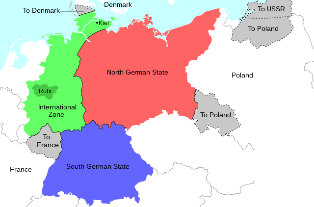
English: Map of the 1944 Morgenthau Plan, which would have seen Germany totally demilitarised and divided into three areas: a Northern state, a Southern state, and a de-industrialised International Zone in the west, administered by "an international security organization, to be established by the United Nations". The International Zone included the Ruhr area, regarded as Germany's industrial heartland, and the important naval port of Kiel. The intention was to prevent Germany from ever again being able to develop military industry or wage war. In addition, the Saar region and surrounding area was to be ceded to France; most of Silesia and southern East Prussia to Poland; northern East Prussia to the USSR; and northern Schleswig to Denmark. |
| วันที่ | |
| แหล่งที่มา | งานของตัว |
| ผู้สร้างสรรค์ | Erinthecute |
| SVG genesis |
การอนุญาตใช้สิทธิ
ข้าพเจ้า ในฐานะผู้ถือลิขสิทธิ์ของภาพหรือสื่อนี้ อนุญาตให้ใช้ภาพหรือสื่อนี้ภายใต้เงื่อนไขต่อไปนี้
ไฟล์นี้อยู่ภายใต้สัญญาอนุญาต ครีเอทีฟคอมมอนส์ แบบแสดงที่มา-อนุญาตแบบเดียวกัน 4.0 นานาชาติ
- คุณสามารถ:
- ที่จะแบ่งปัน – ที่จะทำสำเนา แจกจ่าย และส่งงานดังกล่าวต่อไป
- ที่จะเรียบเรียงใหม่ – ที่จะดัดแปลงงานดังกล่าว
- ภายใต้เงื่อนไขต่อไปนี้:
- แสดงที่มา – คุณต้องให้เกียรติเจ้าของงานอย่างเหมาะสม โดยเพิ่มลิงก์ไปยังสัญญาอนุญาต และระบุหากมีการเปลี่ยนแปลง คุณอาจทำเช่นนี้ได้ในรูปแบบใดก็ได้ตามควร แต่ต้องไม่ใช่ในลักษณะที่แนะว่าผู้ให้อนุญาตสนับสนุนคุณหรือการใช้งานของคุณ
- อนุญาตแบบเดียวกัน – หากคุณดัดแปลง เปลี่ยนรูป หรือต่อเติมงานนี้ คุณต้องใช้สัญญาอนุญาตแบบเดียวกันหรือแบบที่เหมือนกับสัญญาอนุญาตที่ใช้กับงานนี้เท่านั้น
ประวัติไฟล์
คลิกวันที่/เวลาเพื่อดูไฟล์ที่ปรากฏในขณะนั้น
| วันที่/เวลา | รูปย่อ | ขนาด | ผู้ใช้ | ความเห็น | |
|---|---|---|---|---|---|
| ปัจจุบัน | 12:36, 31 กรกฎาคม 2563 | | 671 × 442 (132 กิโลไบต์) | Erinthecute | Fixed background. |
| 12:32, 31 กรกฎาคม 2563 |  | 671 × 442 (131 กิโลไบต์) | Erinthecute | Added highlights of the Ruhr area and Kiel, which were important elements of Moregnthau's plan for deindustrialisation and demilitarisation. | |
| 10:48, 31 กรกฎาคม 2563 |  | 671 × 442 (128 กิโลไบต์) | Erinthecute | Uploaded own work with UploadWizard |
หน้าที่มีภาพนี้
หน้าต่อไปนี้ โยงมาที่ภาพนี้:
การใช้ไฟล์ข้ามโครงการ
วิกิอื่นต่อไปนี้ใช้ไฟล์นี้:
- การใช้บน ar.wikipedia.org
- การใช้บน el.wikipedia.org
- การใช้บน en.wikipedia.org
- การใช้บน he.wikipedia.org
- การใช้บน id.wikipedia.org
- การใช้บน mk.wikipedia.org
- การใช้บน no.wikipedia.org
- การใช้บน pl.wikipedia.org
- การใช้บน tr.wikipedia.org
- การใช้บน vi.wikipedia.org