ไฟล์:Military districts of Russia 2016.svg

ขนาดของตัวอย่าง PNG นี้ของไฟล์ SVG นี้: 800 × 455 พิกเซล ความละเอียดอื่น: 320 × 182 พิกเซล | 640 × 364 พิกเซล | 1,024 × 583 พิกเซล | 1,280 × 728 พิกเซล | 2,560 × 1,457 พิกเซล | 1,107 × 630 พิกเซล
ดูภาพที่มีความละเอียดสูงกว่า ((ไฟล์ SVG, 1,107 × 630 พิกเซล, ขนาดไฟล์: 263 กิโลไบต์))
| รูปภาพหรือไฟล์เสียงนี้ ต้นฉบับอยู่ที่ คอมมอนส์ รายละเอียดด้านล่าง เป็นข้อความที่แสดงผลจาก ไฟล์ต้นฉบับในคอมมอนส์
|

|
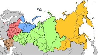
The boundaries on this map show the de facto situation. This is just one of several different views on the subject (see COM:NPOV). |
ความย่อ
| คำอธิบาย |
Русский: Военно-административное деление территории Российской Федерации с 15 декабря 2014 года
Западный военный округ
Северный флот
Южный военный округ
Центральный военный округ
Восточный военный округ English: Areas of responsibility of the 5 Operational Strategic Commands of the Russian Armed Forces since Dec 15th, 2014
Western Operational Strategic Command
Northern Fleet
Southern Operational Strategic Command
Central Operational Strategic Command
Eastern Operational Strategic Command |
| วันที่ | |
| แหล่งที่มา | |
| ผู้สร้างสรรค์ | AlexWelens |

การอนุญาตใช้สิทธิ
ข้าพเจ้า ในฐานะผู้ถือลิขสิทธิ์ของภาพหรือสื่อนี้ อนุญาตให้ใช้ภาพหรือสื่อนี้ภายใต้เงื่อนไขต่อไปนี้
ไฟล์นี้อยู่ภายใต้สัญญาอนุญาต ครีเอทีฟคอมมอนส์ แบบแสดงที่มา-อนุญาตแบบเดียวกัน 4.0 นานาชาติ
- คุณสามารถ:
- ที่จะแบ่งปัน – ที่จะทำสำเนา แจกจ่าย และส่งงานดังกล่าวต่อไป
- ที่จะเรียบเรียงใหม่ – ที่จะดัดแปลงงานดังกล่าว
- ภายใต้เงื่อนไขต่อไปนี้:
- แสดงที่มา – คุณต้องให้เกียรติเจ้าของงานอย่างเหมาะสม โดยเพิ่มลิงก์ไปยังสัญญาอนุญาต และระบุหากมีการเปลี่ยนแปลง คุณอาจทำเช่นนี้ได้ในรูปแบบใดก็ได้ตามควร แต่ต้องไม่ใช่ในลักษณะที่แนะว่าผู้ให้อนุญาตสนับสนุนคุณหรือการใช้งานของคุณ
- อนุญาตแบบเดียวกัน – หากคุณดัดแปลง เปลี่ยนรูป หรือต่อเติมงานนี้ คุณต้องใช้สัญญาอนุญาตแบบเดียวกันหรือแบบที่เหมือนกับสัญญาอนุญาตที่ใช้กับงานนี้เท่านั้น
ประวัติไฟล์
คลิกวันที่/เวลาเพื่อดูไฟล์ที่ปรากฏในขณะนั้น
| วันที่/เวลา | รูปย่อ | ขนาด | ผู้ใช้ | ความเห็น | |
|---|---|---|---|---|---|
| ปัจจุบัน | 05:56, 24 ธันวาคม 2563 | | 1,107 × 630 (263 กิโลไบต์) | AlexWelens | fixed islands according map at mil.ru |
| 22:06, 17 กุมภาพันธ์ 2560 |  | 1,107 × 630 (263 กิโลไบต์) | AlexWelens | Reverted to version as of 16:50, 15 July 2016 (UTC) | |
| 08:38, 9 กุมภาพันธ์ 2560 |  | 1,107 × 630 (489 กิโลไบต์) | Metrancya | The Northern Fleet area of responsibility is only a part of the area of the new "Unified Strategic Command »North«. All territories north of the Arctic Circle will in the future be governed by the "Unified Strategic Command »North«, which then will... | |
| 23:50, 15 กรกฎาคม 2559 |  | 1,107 × 630 (263 กิโลไบต์) | AlexWelens | User created page with UploadWizard |
หน้าที่มีภาพนี้
หน้าต่อไปนี้ โยงมาที่ภาพนี้:
การใช้ไฟล์ข้ามโครงการ
วิกิอื่นต่อไปนี้ใช้ไฟล์นี้:
- การใช้บน ar.wikipedia.org
- การใช้บน ast.wikipedia.org
- การใช้บน be-tarask.wikipedia.org
- การใช้บน bg.wikipedia.org
- การใช้บน cs.wikipedia.org
- การใช้บน da.wikipedia.org
- การใช้บน de.wikipedia.org
- การใช้บน en.wikipedia.org
- การใช้บน es.wikipedia.org
- การใช้บน et.wikipedia.org
- การใช้บน fi.wikipedia.org
- การใช้บน fr.wikipedia.org
- การใช้บน he.wikipedia.org
- การใช้บน hu.wikipedia.org
- การใช้บน it.wikipedia.org
- การใช้บน ja.wikipedia.org
ดูการใช้ข้ามโครงการเพิ่มเติมของไฟล์นี้