ไฟล์:Map of Sunda and Sahul.png
ขนาดของตัวอย่างนี้: 661 × 599 พิกเซล ความละเอียดอื่น: 265 × 240 พิกเซล | 530 × 480 พิกเซล | 847 × 768 พิกเซล | 1,111 × 1,007 พิกเซล
ดูภาพที่มีความละเอียดสูงกว่า (1,111 × 1,007 พิกเซล, ขนาดไฟล์: 208 กิโลไบต์, ชนิดไมม์: image/png)
| รูปภาพหรือไฟล์เสียงนี้ ต้นฉบับอยู่ที่ คอมมอนส์ รายละเอียดด้านล่าง เป็นข้อความที่แสดงผลจาก ไฟล์ต้นฉบับในคอมมอนส์
|

|
ภาพนี้มีภาพในรูปแบบเวกเตอร์ (SVG)
หากภาพ SVG ทำให้การแสดงผลดีกว่า หน้าที่ใช้ภาพนี้ควรเปลี่ยนไปใช้ภาพ SVG แทน File:Map of Sunda and Sahul.png → File:Map of Sunda and Sahul.svg
สำหรับข้อมูลเพิ่มเติมเกี่ยวกับภาพเวกเตอร์ ดูที่ การเปลี่ยนไปใช้ภาพ SVG ในคอมมอนส์ นอกจากนี้สามารถดูเพิ่มเติมเกี่ยวกับ ข้อมูลเกี่ยวกับการรองรับภาพ SVG สำหรับซอฟต์แวร์มีเดียวิกิ ได้ |
 |
| คำอธิบาย |
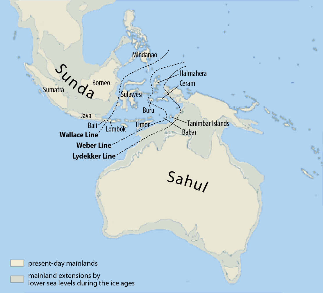
Deutsch: Karte von Sunda und Sahul sowie der Wallace-Linie, der Lydekker-Linie und der Weber-Linie.
Français : Carte de Sunda, de Sahul et de la ligne Wallace, de la ligne Lydekker et de la ligne Weber
Español: Mapa de Sunda y Sahul con la línea de Wallace, la línea de Lydekker y la línea de Weber.
|
| วันที่ | |
| แหล่งที่มา | Self made, using this map for the background |
| ผู้สร้างสรรค์ | Maximilian Dörrbecker (Chumwa) |
| การอนุญาต (การใช้ไฟล์นี้ใหม่) |
ข้าพเจ้า ในฐานะผู้ถือลิขสิทธิ์ของภาพหรือสื่อนี้ อนุญาตให้ใช้ภาพหรือสื่อนี้ภายใต้เงื่อนไขต่อไปนี้ ไฟล์นี้อยู่ภายใต้สัญญาอนุญาต ครีเอทีฟคอมมอนส์ แบบแสดงที่มา-อนุญาตแบบเดียวกัน 3.0 ต้นฉบับ
Sie dürfen das Bild zu den folgenden Bedingungen nutzen:
|
| เวอร์ชันอื่น |
|


ประวัติไฟล์
คลิกวันที่/เวลาเพื่อดูไฟล์ที่ปรากฏในขณะนั้น
| วันที่/เวลา | รูปย่อ | ขนาด | ผู้ใช้ | ความเห็น | |
|---|---|---|---|---|---|
| ปัจจุบัน | 15:07, 5 มีนาคม 2560 | | 1,111 × 1,007 (208 กิโลไบต์) | Chumwa | corr |
| 13:46, 25 กรกฎาคม 2552 |  | 1,111 × 1,007 (269 กิโลไบต์) | Chumwa | Inseln -> Islands | |
| 13:13, 25 กรกฎาคม 2552 |  | 1,111 × 1,007 (268 กิโลไบต์) | Chumwa | {{Information |Description= {{ de }}Karte von Sunda und Sahul sowie der Wallace-Linie, der Lydekker-Linie und der Weber-Linie. * Als Sahul wird die zusammenhängende Landmasse bezeichnet, die während der letzten Eiszeit aus Australien, der nordöstlich d |
หน้าที่มีภาพนี้
หน้าต่อไปนี้ โยงมาที่ภาพนี้:
การใช้ไฟล์ข้ามโครงการ
วิกิอื่นต่อไปนี้ใช้ไฟล์นี้:
- การใช้บน ar.wikipedia.org
- การใช้บน ast.wikipedia.org
- การใช้บน be.wikipedia.org
- การใช้บน bg.wikipedia.org
- การใช้บน bn.wikipedia.org
- การใช้บน ca.wikipedia.org
- การใช้บน cs.wikipedia.org
- การใช้บน de.wikipedia.org
- การใช้บน en.wikipedia.org
- Dingo
- New Guinea singing dog
- List of lost lands
- Red-naped trogon
- Models of migration to the Philippines
- Denisovan
- Canis lupus dingo
- User:Cruickshanks/Sandbox
- User:Obsidian Soul/sandbox
- Wikipedia:Reference desk/Archives/Science/2011 May 15
- List of butterflies of the Philippines
- Wikipedia:Categories for discussion/Log/2015 June 26
- การใช้บน eo.wikipedia.org
- การใช้บน es.wikipedia.org
- การใช้บน fa.wikipedia.org
- การใช้บน fi.wikipedia.org
- การใช้บน fr.wikipedia.org
- การใช้บน gl.wikipedia.org
ดูการใช้ข้ามโครงการเพิ่มเติมของไฟล์นี้