ไฟล์:Map Kingdom of Westphalia.jpg
ไม่มีภาพที่มีรายละเอียดสูงกว่านี้
Map_Kingdom_of_Westphalia.jpg (348 × 409 พิกเซล, ขนาดไฟล์: 68 กิโลไบต์, ชนิดไมม์: image/jpeg)
| รูปภาพหรือไฟล์เสียงนี้ ต้นฉบับอยู่ที่ คอมมอนส์ รายละเอียดด้านล่าง เป็นข้อความที่แสดงผลจาก ไฟล์ต้นฉบับในคอมมอนส์
|
ความย่อ
| คำอธิบาย |
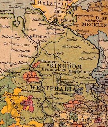
Nederlands: Koninkrijk Westfalen |
||||||||||||||||||||||
| วันที่ | |||||||||||||||||||||||
| แหล่งที่มา | From The Historical Atlas by William R. Shepherd, 1926. | ||||||||||||||||||||||
| ผู้สร้างสรรค์ |
|
||||||||||||||||||||||
| การอนุญาต (การใช้ไฟล์นี้ใหม่) |
PCL states map is PD | ||||||||||||||||||||||
การอนุญาตใช้สิทธิ
ผู้สร้างสรรค์งานนี้เสียชีวิตในปี ค.ศ. 1934 ดังนั้นงานนี้จึงเป็นสาธารณสมบัติ ในประเทศต้นกำเนิดและประเทศอื่น ๆ ที่ระยะเวลาการคุ้มครองลิขสิทธิ์น้อยกว่า 80 ปีหลังจากผู้สร้างสรรค์งานเสียชีวิต. | |
| ไฟล์นี้ได้ถูกระบุว่าไม่มีข้อจำกัดภายใต้กฎหมายลิขสิทธิ์ รวมถึงสิทธิที่เกี่ยวข้องและที่ใกล้เคียงกัน | |
This work is in the public domain because it was published in the United States between 1929 and 1963, and although there may or may not have been a copyright notice, the copyright was not renewed. For further explanation, see Commons:Hirtle chart and the copyright renewal logs. Note that it may still be copyrighted in jurisdictions that do not apply the rule of the shorter term for US works (depending on the date of the author's death), such as Canada (70 years p.m.a.), Mainland China (50 years p.m.a., not Hong Kong or Macao), Germany (70 years p.m.a.), Mexico (100 years p.m.a.), Switzerland (70 years p.m.a.), and other countries with individual treaties.
|
 |
บันทึกการอัพโหลด
- Originally from nl.wikipedia; description page is/was here.
(All user names refer to nl.wikipedia)
- 2004-08-16 09:49 Känsterle 348×409×8 (69732 bytes) Koninkrijk Westfalen - vrij te gebruiken voor educatieve doeleinden - http://www.lib.utexas.edu/maps/historical/
Map of the principality (later free state) of Lippe 1815–1945. From German Wikipedia and according to information there "Gemeinfrei" = public domain. {{PD-user|Störfix}}
ประวัติไฟล์
คลิกวันที่/เวลาเพื่อดูไฟล์ที่ปรากฏในขณะนั้น
| วันที่/เวลา | รูปย่อ | ขนาด | ผู้ใช้ | ความเห็น | |
|---|---|---|---|---|---|
| ปัจจุบัน | 16:38, 4 มีนาคม 2550 | | 348 × 409 (68 กิโลไบต์) | SieBot | {{Information |Description=Koninkrijk Westfalen {{PD-PCL|central_europe_1812.jpg|historical/shepherd/}} |Source=Originally from [http://nl.wikipedia.org nl.wikipedia]; description page is/was [http://nl.wikipedia.org/w/index.php?title=Image%3AKWestfale |
หน้าที่มีภาพนี้
ไม่มีหน้าใดโยงมาที่ภาพนี้
การใช้ไฟล์ข้ามโครงการ
วิกิอื่นต่อไปนี้ใช้ไฟล์นี้:
- การใช้บน ca.wikipedia.org
- การใช้บน el.wikipedia.org
- การใช้บน eo.wikipedia.org
- การใช้บน et.wikipedia.org
- การใช้บน fa.wikipedia.org
- การใช้บน he.wikipedia.org
- การใช้บน id.wikipedia.org
- การใช้บน it.wikipedia.org
- การใช้บน ro.wikipedia.org
- การใช้บน sr.wikipedia.org
- การใช้บน zh.wikipedia.org