ไฟล์:Map-of-southeast-asia 1000 - 1100 CE.png

ขนาดของตัวอย่างนี้: 426 × 600 พิกเซล ความละเอียดอื่น: 170 × 240 พิกเซล | 341 × 480 พิกเซล | 791 × 1,114 พิกเซล
ดูภาพที่มีความละเอียดสูงกว่า (791 × 1,114 พิกเซล, ขนาดไฟล์: 162 กิโลไบต์, ชนิดไมม์: image/png)
| รูปภาพหรือไฟล์เสียงนี้ ต้นฉบับอยู่ที่ คอมมอนส์ รายละเอียดด้านล่าง เป็นข้อความที่แสดงผลจาก ไฟล์ต้นฉบับในคอมมอนส์
|
3ㅐㅛㅑ혀댜해ㅔㅎ재ㅗ3ㅐㅗ39햐3호9ㅍ뎌ㅗㅑㅑㄷ
ความย่อ
| คำอธิบาย |
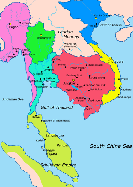
English: Map of Mainland Southeast Asia circa 1000 - 1100 CE, showing Khmer Empire in red, Lavo kingdom/Dvaravati in light blue, Haripunjaya in green, Champa in yellow, Dai Viet in blue, Kingdom of Pagan in pink, Srivijaya in lime and surrounding states.
sources http://ecaimaps.berkeley.edu/animations/2003_03_khmer_animation.swf http://www.britannica.com/EBchecked/media/3395/Khmer-empire-1200 Atlas of world history, Patrick Karl O'brien Societies, Networks, and Transitions: A Global History, Volume B. Craig A.Lockard http://upload.wikimedia.org/wikipedia/commons/thumb/4/45/Srivijaya_Empire.svg/2000px-Srivijaya_Empire.svg.png File:DvaravatiMapThailand.png http://upload.wikimedia.org/wikipedia/commons/e/eb/Thailand_2002_CIA_map.jpg |
| วันที่ | |
| แหล่งที่มา | งานของตัว |
| ผู้สร้างสรรค์ | Javierfv1212 |
การอนุญาตใช้สิทธิ
ข้าพเจ้า ในฐานะผู้ถือลิขสิทธิ์ของภาพหรือสื่อนี้ อนุญาตให้ใช้ภาพหรือสื่อนี้ภายใต้เงื่อนไขต่อไปนี้
| ไฟล์นี้มีให้ใช้ภายใต้ CC0 1.0 Universal Public Domain Dedication ของครีเอทีฟคอมมอนส์ | |
| The person who associated a work with this deed has dedicated the work to the public domain by waiving all of their rights to the work worldwide under copyright law, including all related and neighboring rights, to the extent allowed by law. You can copy, modify, distribute and perform the work, even for commercial purposes, all without asking permission.
|

|
ภาพแผนที่ทางประวัติศาสตร์นี้ ควรจะถูกสร้างใหม่เป็นกราฟิกส์เวกเตอร์ ซึ่งมีข้อดีอีกหลายประการ ดูเพิ่มเติมที่คอมมอนส์:สื่อต้องการเก็บกวาดสำหรับสารสนเทศเพิ่มเติม หากภาพนี้มีในรูปแบบกราฟิกส์เวกเตอร์อยู่แล้ว กรุณาอัปโหลดและแทนที่แม่แบบนี้ด้วย
{{vector version available|ชื่อภาพใหม่}}
แนะนำเป็นอย่างยิ่งให้ตั้งชื่อไฟล์เวกเตอร์ใหม่นั้นในรูปแบบ "Map-of-southeast-asia 1000 - 1100 CE.svg" แล้วใส่แม่แบบ Vector version available (หรือ Vva) ซึ่งไม่ต้องใช้พารามิเตอร์ ชื่อภาพใหม่ |
ประวัติไฟล์
คลิกวันที่/เวลาเพื่อดูไฟล์ที่ปรากฏในขณะนั้น
| วันที่/เวลา | รูปย่อ | ขนาด | ผู้ใช้ | ความเห็น | |
|---|---|---|---|---|---|
| ปัจจุบัน | 04:57, 20 กรกฎาคม 2554 | | 791 × 1,114 (162 กิโลไบต์) | Ras67 | cropped |
| 09:18, 28 มีนาคม 2554 |  | 800 × 1,125 (224 กิโลไบต์) | Javierfv1212 | {{Information |Description ={{en|1=Map of Southeast Asia circa 1000 - 1100 CE, showing Khmer Empire in red, Lavo kingdom/Dvaravati in light blue, Haripunjaya in green, Champa in yellow and surrounding states. sources http://ecaimaps.berkeley.edu/an |
หน้าที่มีภาพนี้
หน้าต่อไปนี้ โยงมาที่ภาพนี้:
การใช้ไฟล์ข้ามโครงการ
วิกิอื่นต่อไปนี้ใช้ไฟล์นี้:
- การใช้บน af.wikipedia.org
- การใช้บน ar.wikipedia.org
- การใช้บน ast.wikipedia.org
- การใช้บน ba.wikipedia.org
- การใช้บน bn.wikipedia.org
- การใช้บน ca.wikipedia.org
- การใช้บน de.wikipedia.org
- การใช้บน el.wikipedia.org
- การใช้บน en.wikipedia.org
- การใช้บน eu.wikipedia.org
- การใช้บน fr.wikipedia.org
- การใช้บน gl.wikipedia.org
- การใช้บน hi.wikipedia.org
- การใช้บน id.wikipedia.org
- การใช้บน incubator.wikimedia.org
- การใช้บน it.wikipedia.org
- การใช้บน ja.wikipedia.org
- การใช้บน km.wikipedia.org
- การใช้บน ko.wikipedia.org
- การใช้บน lfn.wikipedia.org
- การใช้บน lt.wikipedia.org
- การใช้บน ml.wikipedia.org
- การใช้บน mn.wikipedia.org
- การใช้บน no.wikipedia.org
- การใช้บน pt.wikipedia.org
- การใช้บน ru.wikipedia.org
- การใช้บน sh.wikipedia.org
- การใช้บน sl.wikipedia.org
- การใช้บน uk.wikipedia.org
- การใช้บน vi.wikipedia.org
ดูการใช้ข้ามโครงการเพิ่มเติมของไฟล์นี้