ไฟล์:Location greek ancient.png
ไม่มีภาพที่มีรายละเอียดสูงกว่านี้
Location_greek_ancient.png (248 × 113 พิกเซล, ขนาดไฟล์: 4 กิโลไบต์, ชนิดไมม์: image/png)
| รูปภาพหรือไฟล์เสียงนี้ ต้นฉบับอยู่ที่ คอมมอนส์ รายละเอียดด้านล่าง เป็นข้อความที่แสดงผลจาก ไฟล์ต้นฉบับในคอมมอนส์
|
ความย่อ
| คำอธิบาย |
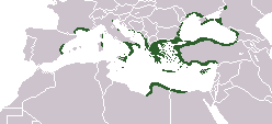
English: Locator map depicting the ancient Greek world, c. 550 BC |
|||
| วันที่ | ||||
| แหล่งที่มา | Self-created, after http://www.wwnorton.com/nrl/english/nawol/maps/MAP7GRCO.JPG | |||
| ผู้สร้างสรรค์ | User:ChrisO | |||
| การอนุญาต (การใช้ไฟล์นี้ใหม่) |
|
|||
| เวอร์ชันอื่น |
|


ประวัติไฟล์
คลิกวันที่/เวลาเพื่อดูไฟล์ที่ปรากฏในขณะนั้น
| วันที่/เวลา | รูปย่อ | ขนาด | ผู้ใช้ | ความเห็น | |
|---|---|---|---|---|---|
| ปัจจุบัน | 23:20, 27 กันยายน 2564 | | 248 × 113 (4 กิโลไบต์) | Deji Olajide1999 | Added the missing regions of Orestis, Elimiotis, Eordaia and Tymphaea + cleared up the Greek colonies in Thrace. |
| 16:22, 23 มกราคม 2561 |  | 248 × 113 (4 กิโลไบต์) | Maphobbyist | Added Colchis. | |
| 23:15, 26 มิถุนายน 2557 |  | 248 × 113 (6 กิโลไบต์) | SilentResident | Added missing kingdom of Epirus | |
| 17:55, 29 ธันวาคม 2555 |  | 248 × 113 (5 กิโลไบต์) | Gepgepgep | Aggiunta l'area di colonizzazione greca dell'Adriatico, che mancava completamente | |
| 00:22, 6 กันยายน 2554 |  | 248 × 113 (5 กิโลไบต์) | Spesh531 | Showing borders that are recognized. Still showing unrecognized countries for a reference of where Ancient Greek was. It was also about the shape of the lands, as Greek Islands where either not shown correctly or not there at all | |
| 20:00, 5 กันยายน 2554 |  | 248 × 113 (4 กิโลไบต์) | Maphobbyist | Pfrevious user Saguamundi is right. International borders, and NOT disputed borders must be shown. Nor is this about the present but about historical Greek settlements. There is no place for current politics for a historical map. | |
| 05:28, 5 กันยายน 2554 |  | 248 × 113 (5 กิโลไบต์) | Spesh531 | Reverted to version as of 01:56, 11 May 2011 The border were fine, your showing territories where some are unrecognizable | |
| 05:21, 5 กันยายน 2554 |  | 248 × 113 (5 กิโลไบต์) | Spesh531 | Reverted to version as of 01:56, 11 May 2011 The border were fine, your showing territories where some are unrecognizable | |
| 04:26, 5 กันยายน 2554 |  | 248 × 113 (4 กิโลไบต์) | Saguamundi | Same map but with internationally recognized borders. | |
| 08:56, 11 พฤษภาคม 2554 |  | 248 × 113 (5 กิโลไบต์) | Spesh531 | update more to source, the current Greece was not under territory. |
หน้าที่มีภาพนี้
ไม่มีหน้าใดโยงมาที่ภาพนี้
การใช้ไฟล์ข้ามโครงการ
วิกิอื่นต่อไปนี้ใช้ไฟล์นี้:
- การใช้บน en.wikipedia.org
- การใช้บน pl.wikibooks.org