ไฟล์:Location Ardennes.PNG
ไม่มีภาพที่มีรายละเอียดสูงกว่านี้
Location_Ardennes.PNG (506 × 439 พิกเซล, ขนาดไฟล์: 40 กิโลไบต์, ชนิดไมม์: image/png)
| รูปภาพหรือไฟล์เสียงนี้ ต้นฉบับอยู่ที่ คอมมอนส์ รายละเอียดด้านล่าง เป็นข้อความที่แสดงผลจาก ไฟล์ต้นฉบับในคอมมอนส์
|
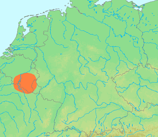
| คำอธิบาย | Locator maps for mountain ranges : Location Ardennes.PNG |
| แหล่งที่มา | demis maps, see below |
| ผู้สร้างสรรค์ | 13:44, 29 June 2007 (UTC) |
This image is in the public domain because it came from the site https://www.demis.nl/products/web-map-server/examples/ and was released by the copyright holder. Permission is granted to copy, distribute and/or modify this map since it is based on free of copyright images from: www.demis.nl. See also approval email on de.wp and its clarification.
|
| This work has been released into the public domain by its copyright holder, www.demis.nl. This applies worldwide. ในบางประเทศ การกระทำดังกล่าวอาจไม่สามารถทำได้ตามกฎหมาย www.demis.nl อนุญาตให้ทุกคนมีสิทธิ์ในการใช้ไฟล์นี้ในทุกเหตุผลการใช้ โดยไม่มีมีเงื่อนไข เว้นแต่กฎหมายไม่อนุญาตให้ทำเช่นนั้น
|
ประวัติไฟล์
คลิกวันที่/เวลาเพื่อดูไฟล์ที่ปรากฏในขณะนั้น
| วันที่/เวลา | รูปย่อ | ขนาด | ผู้ใช้ | ความเห็น | |
|---|---|---|---|---|---|
| ปัจจุบัน | 20:42, 29 มิถุนายน 2550 | | 506 × 439 (40 กิโลไบต์) | Michiel1972 | {{Information |Description=Locator maps for mountain ranges : {{subst:PAGENAME}} |Source=demis maps, see below |Date= |Author={{Statistics Netherlands map}} |Permission=see below |other_versions= }} {{PD-Demis}} [[Category:Maps of mountain_ranges_of_Eu |
หน้าที่มีภาพนี้
หน้าต่อไปนี้ โยงมาที่ภาพนี้:
การใช้ไฟล์ข้ามโครงการ
วิกิอื่นต่อไปนี้ใช้ไฟล์นี้:
- การใช้บน af.wikipedia.org
- การใช้บน ar.wikipedia.org
- การใช้บน arz.wikipedia.org
- การใช้บน be-tarask.wikipedia.org
- การใช้บน ca.wikipedia.org
- การใช้บน ceb.wikipedia.org
- การใช้บน cs.wikipedia.org
- การใช้บน de.wikipedia.org
- การใช้บน de.wiktionary.org
- การใช้บน en.wikipedia.org
- การใช้บน eo.wikipedia.org
- การใช้บน es.wikipedia.org
- การใช้บน eu.wikipedia.org
- การใช้บน fy.wikipedia.org
- การใช้บน hy.wikipedia.org
- การใช้บน ia.wikipedia.org
- การใช้บน incubator.wikimedia.org
- การใช้บน is.wikipedia.org
- การใช้บน ja.wikipedia.org
- การใช้บน ko.wikipedia.org
- การใช้บน li.wikipedia.org
- การใช้บน lt.wikipedia.org
- การใช้บน ms.wikipedia.org
- การใช้บน pcd.wikipedia.org
- การใช้บน pl.wikipedia.org
- การใช้บน pl.wiktionary.org
- การใช้บน pnb.wikipedia.org
- การใช้บน simple.wikipedia.org
- การใช้บน sk.wikipedia.org
- การใช้บน sv.wikipedia.org
- การใช้บน uk.wikipedia.org
- การใช้บน wa.wikipedia.org
- การใช้บน www.wikidata.org
- การใช้บน zh-yue.wikipedia.org
- การใช้บน zh.wikipedia.org