ไฟล์:LA2-Europe-UTM-zones.png

ขนาดของตัวอย่างนี้: 553 × 599 พิกเซล ความละเอียดอื่น: 221 × 240 พิกเซล | 443 × 480 พิกเซล | 960 × 1,040 พิกเซล
ดูภาพที่มีความละเอียดสูงกว่า (960 × 1,040 พิกเซล, ขนาดไฟล์: 219 กิโลไบต์, ชนิดไมม์: image/png)
| รูปภาพหรือไฟล์เสียงนี้ ต้นฉบับอยู่ที่ คอมมอนส์ รายละเอียดด้านล่าง เป็นข้อความที่แสดงผลจาก ไฟล์ต้นฉบับในคอมมอนส์
|
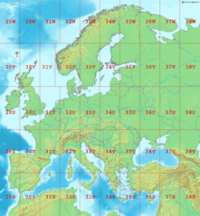
Map of Europe, showing the latitude and longitude zones of the en:Universal Transverse Mercator coordinate system, from 29S to 38W.
Bounding box West -12°, South 32°, East 48°, North 72°. Center at 52°00′N 18°00′E / 52.00°N 18.00°E.
This image is in the public domain because it came from the site https://www.demis.nl/products/web-map-server/examples/ and was released by the copyright holder. Permission is granted to copy, distribute and/or modify this map since it is based on free of copyright images from: www.demis.nl. See also approval email on de.wp and its clarification.
|
| This work has been released into the public domain by its copyright holder, www.demis.nl. This applies worldwide. ในบางประเทศ การกระทำดังกล่าวอาจไม่สามารถทำได้ตามกฎหมาย www.demis.nl อนุญาตให้ทุกคนมีสิทธิ์ในการใช้ไฟล์นี้ในทุกเหตุผลการใช้ โดยไม่มีมีเงื่อนไข เว้นแต่กฎหมายไม่อนุญาตให้ทำเช่นนั้น
|
ประวัติไฟล์
คลิกวันที่/เวลาเพื่อดูไฟล์ที่ปรากฏในขณะนั้น
| วันที่/เวลา | รูปย่อ | ขนาด | ผู้ใช้ | ความเห็น | |
|---|---|---|---|---|---|
| ปัจจุบัน | 06:10, 2 กันยายน 2549 | | 960 × 1,040 (219 กิโลไบต์) | LA2 | Map of Europe, showing the latitude and longitude zones of the en:Universal Transverse Mercator coordinate system, from 29S to 38W. Bounding box West -12°, South 32°, East 49°, North 72°. Center at {{coor d|52.00000|N|18.50000|E|scale:24000000}} |
หน้าที่มีภาพนี้
หน้าต่อไปนี้ โยงมาที่ภาพนี้:
การใช้ไฟล์ข้ามโครงการ
วิกิอื่นต่อไปนี้ใช้ไฟล์นี้:
- การใช้บน ar.wikipedia.org
- การใช้บน ca.wikipedia.org
- การใช้บน da.wikipedia.org
- การใช้บน de.wikipedia.org
- การใช้บน en.wikipedia.org
- การใช้บน es.wikipedia.org
- การใช้บน fa.wikipedia.org
- การใช้บน fi.wikipedia.org
- การใช้บน fr.wikipedia.org
- การใช้บน gl.wikipedia.org
- การใช้บน he.wikipedia.org
- การใช้บน hu.wikipedia.org
- การใช้บน ja.wikipedia.org
- การใช้บน nl.wikipedia.org
- การใช้บน no.wikipedia.org
- การใช้บน pl.wikipedia.org
- การใช้บน pt.wikipedia.org
- การใช้บน sr.wikipedia.org
- การใช้บน sv.wikipedia.org