ไฟล์:Kokuritsu Yoyogi Kyōgijō 1.jpg
ดูภาพที่มีความละเอียดสูงกว่า (4,412 × 2,941 พิกเซล, ขนาดไฟล์: 8.81 เมกะไบต์, ชนิดไมม์: image/jpeg)
| รูปภาพหรือไฟล์เสียงนี้ ต้นฉบับอยู่ที่ คอมมอนส์ รายละเอียดด้านล่าง เป็นข้อความที่แสดงผลจาก ไฟล์ต้นฉบับในคอมมอนส์
|
ความย่อ
| คำอธิบาย |
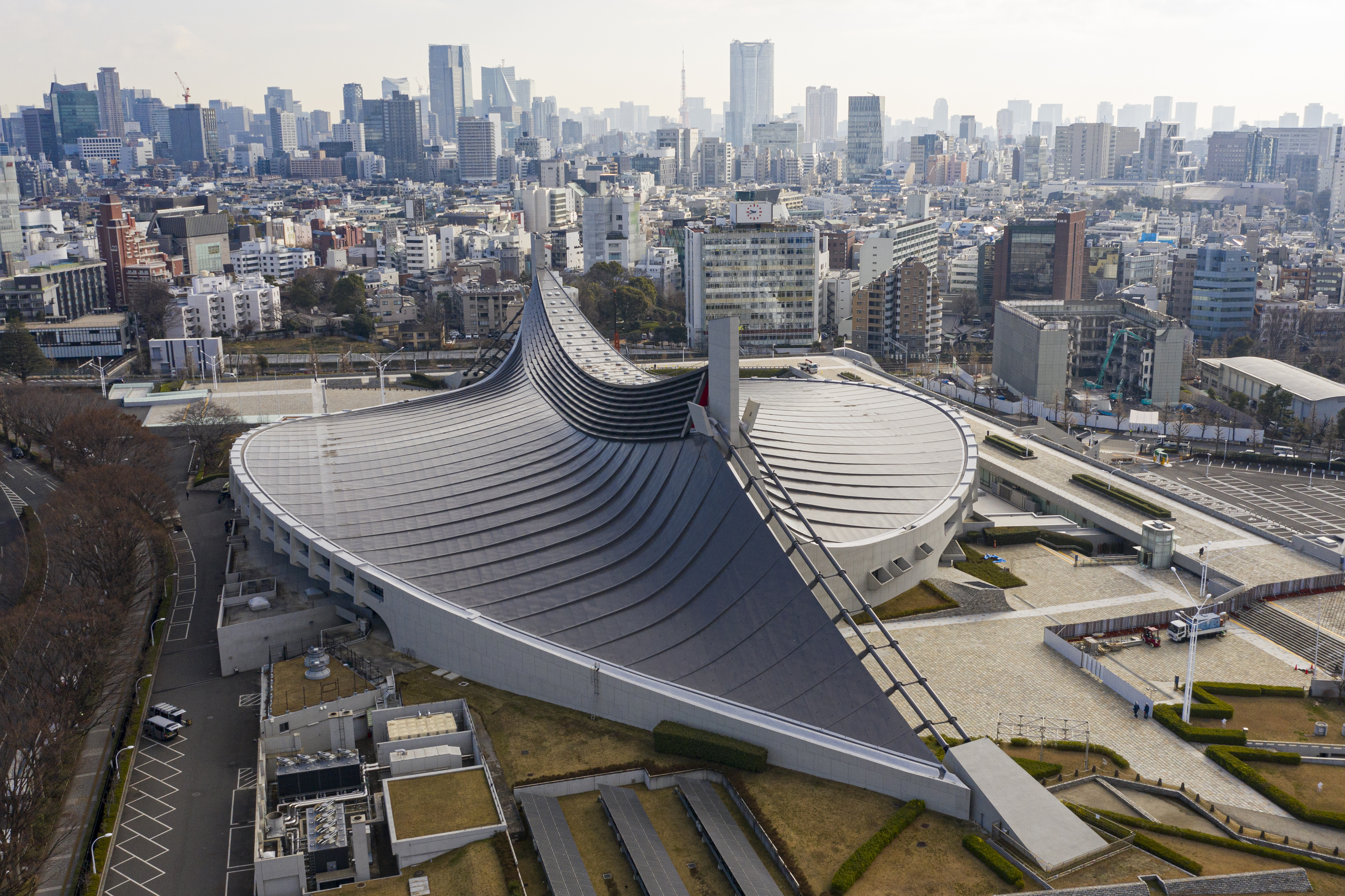
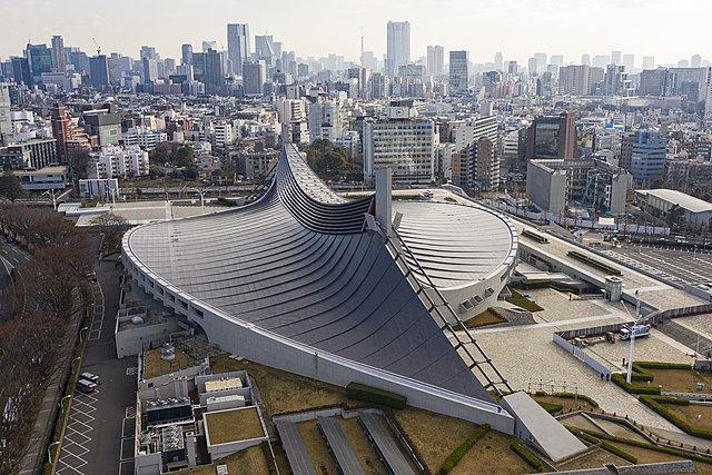
English: Aerial view of Kokuritsu Yoyogi Kyōgijō, Tokyo, Japan |
|||||||||||||||||
| วันที่ | ||||||||||||||||||
| แหล่งที่มา | งานของตัว | |||||||||||||||||
| ผู้สร้างสรรค์ |
|
|||||||||||||||||
| การอนุญาต (การใช้ไฟล์นี้ใหม่) |
I published this file as author under the Creative Commons License CC-by-SA-3.0.. This means that a ‘free use outside Wikimedia’s projects’ is only possible under the following conditions:
I would be very grateful if you could send me a specimen copy of the photo/map or the details of the website where the photo/map will be used. Basically, all my photos and maps can be licensed under the conditions of the Mittelstandsgemeinschaft Foto-Marketing (MFM). Please send an email to lizenz AT arne-mueseler.de if you
Arne Müseler / www.arne-mueseler.com ในฐานะผู้ถือลิขสิทธิ์ของภาพหรือสื่อนี้ อนุญาตให้ใช้ภาพหรือสื่อนี้ภายใต้เงื่อนไขต่อไปนี้ ไฟล์นี้อยู่ภายใต้สัญญาอนุญาต ครีเอทีฟคอมมอนส์ แบบแสดงที่มา-อนุญาตแบบเดียวกัน 3.0 ของประเทศเยอรมนี การแสดงที่มา: Arne Müseler / www.arne-mueseler.com
 |
|||||||||||||||||

| ตำแหน่งที่ตั้งกล้อง | | ภาพนี้และภาพอื่น ๆ ณ สถานที่เดียวกันที่ OpenStreetMap |
|---|

|
ภาพนี้ได้รับการประเมินภายใต้ เกณฑ์ภาพอันทรงคุณค่า และถือว่าเป็น ภาพอันทรงคุณค่าที่สุดในคอมมอนส์ ภายใต้ขอบเขต: Aerial view of Yoyogi National Gymnasium. คุณสามารถดูการเสนอชื่อได้ ที่นี่. |
ประวัติไฟล์
คลิกวันที่/เวลาเพื่อดูไฟล์ที่ปรากฏในขณะนั้น
| วันที่/เวลา | รูปย่อ | ขนาด | ผู้ใช้ | ความเห็น | |
|---|---|---|---|---|---|
| ปัจจุบัน | 22:29, 15 มกราคม 2563 | | 4,412 × 2,941 (8.81 เมกะไบต์) | Arne Müseler | {{Information |description={{en|1=Aerial view of Kokuritsu Yoyogi Kyōgijō, Tokyo, Japan}} |source={{own}} |Author={{User:Arne mueseler/Autor}} |Permission={{Template:ArneMueselerCredit}} |other_versions= }} {{Location|35.667669|139.700174}} Category:Kokuritsu Yoyogi Kyōgijō Category:Japan - Photographs by Arne Müseler |
หน้าที่มีภาพนี้
หน้าต่อไปนี้ โยงมาที่ภาพนี้:
การใช้ไฟล์ข้ามโครงการ
วิกิอื่นต่อไปนี้ใช้ไฟล์นี้:
- การใช้บน ar.wikipedia.org
- การใช้บน bg.wikipedia.org
- การใช้บน ca.wikipedia.org
- การใช้บน cs.wikipedia.org
- การใช้บน da.wikipedia.org
- การใช้บน de.wikipedia.org
- การใช้บน de.wikivoyage.org
- การใช้บน en.wikipedia.org
- Tokyo
- Kenzō Tange
- 1964 Summer Olympics
- Shibuya
- Modern architecture
- Japanese architecture
- 2020 Summer Olympics
- The Yellow Monkey
- Yoyogi National Gymnasium
- Expressionist architecture
- Swimming at the 1964 Summer Olympics
- Architecture of Tokyo
- List of Olympic venues in swimming
- Suspended structure
- Miss International 2023
- 2023 FIVB Volleyball Men's Olympic Qualification Tournaments
- 2023 FIVB Volleyball Women's Olympic Qualification Tournaments
- User:Triila73/sandbox/What should Miss International 2023 really look like?
- การใช้บน eo.wikipedia.org
- การใช้บน es.wikipedia.org
- การใช้บน eu.wikipedia.org
- การใช้บน fa.wikipedia.org
- การใช้บน fy.wikipedia.org
- การใช้บน gl.wikipedia.org
- การใช้บน he.wikipedia.org
- การใช้บน hy.wikipedia.org
- การใช้บน id.wikipedia.org
- การใช้บน incubator.wikimedia.org
ดูการใช้ข้ามโครงการเพิ่มเติมของไฟล์นี้