ไฟล์:Island of Ireland location map Tyrone.svg

ขนาดของตัวอย่าง PNG นี้ของไฟล์ SVG นี้: 796 × 599 พิกเซล ความละเอียดอื่น: 319 × 240 พิกเซล | 638 × 480 พิกเซล | 1,020 × 768 พิกเซล | 1,280 × 964 พิกเซล | 2,560 × 1,928 พิกเซล | 931 × 701 พิกเซล
ดูภาพที่มีความละเอียดสูงกว่า ((ไฟล์ SVG, 931 × 701 พิกเซล, ขนาดไฟล์: 826 กิโลไบต์))
| รูปภาพหรือไฟล์เสียงนี้ ต้นฉบับอยู่ที่ คอมมอนส์ รายละเอียดด้านล่าง เป็นข้อความที่แสดงผลจาก ไฟล์ต้นฉบับในคอมมอนส์
|
| คำอธิบาย |
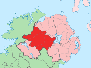
English: The island of Ireland, showing international border between Northern Ireland and Republic of Ireland, traditional provinces, traditional counties, and local authority areas in the Republic of Ireland and Northern Ireland. |
||
| วันที่ | (UTC) | ||
| แหล่งที่มา | Island of Ireland location map.svg | ||
| ผู้สร้างสรรค์ | |||
| SVG genesis | ซอร์สโค้ดของ SVG นี้ตรวจสอบถูกต้องแล้ว ไฟล์ภาพกราฟิกส์เวกเตอร์นี้ สร้างขึ้นโดยใช้ Adobe Illustrator
|
ข้าพเจ้า ในฐานะผู้ถือลิขสิทธิ์ของภาพหรือสื่อนี้ อนุญาตให้ใช้ภาพหรือสื่อนี้ภายใต้เงื่อนไขต่อไปนี้
ไฟล์นี้อยู่ภายใต้สัญญาอนุญาต ครีเอทีฟคอมมอนส์ แบบแสดงที่มา-อนุญาตแบบเดียวกัน 3.0 ต้นฉบับ
- คุณสามารถ:
- ที่จะแบ่งปัน – ที่จะทำสำเนา แจกจ่าย และส่งงานดังกล่าวต่อไป
- ที่จะเรียบเรียงใหม่ – ที่จะดัดแปลงงานดังกล่าว
- ภายใต้เงื่อนไขต่อไปนี้:
- แสดงที่มา – คุณต้องให้เกียรติเจ้าของงานอย่างเหมาะสม โดยเพิ่มลิงก์ไปยังสัญญาอนุญาต และระบุหากมีการเปลี่ยนแปลง คุณอาจทำเช่นนี้ได้ในรูปแบบใดก็ได้ตามควร แต่ต้องไม่ใช่ในลักษณะที่แนะว่าผู้ให้อนุญาตสนับสนุนคุณหรือการใช้งานของคุณ
- อนุญาตแบบเดียวกัน – หากคุณดัดแปลง เปลี่ยนรูป หรือต่อเติมงานนี้ คุณต้องใช้สัญญาอนุญาตแบบเดียวกันหรือแบบที่เหมือนกับสัญญาอนุญาตที่ใช้กับงานนี้เท่านั้น
บันทึกการอัพโหลด
This image is a derivative work of the following images:
- Island of Ireland location map.svg licensed with Cc-by-sa-3.0
- 2010-03-06T20:43:33Z Rannpháirtí anaithnid 1450x1807 (679207 Bytes) Fix incorrectly coloured isands.
- 2010-03-03T22:19:29Z Rannpháirtí anaithnid 1450x1807 (679744 Bytes) {{Information |Description={{de|Positionskarte von [[:de:Irland|Irland]]}} Quadratische Plattkarte, N-S-Streckung 170 %. Geographische Begrenzung der Karte: * N: 55.6° N * S: 51.2° N * W: 11.0° W * O: 5.0° W {{en|Location
Uploaded with derivativeFX
ประวัติไฟล์
คลิกวันที่/เวลาเพื่อดูไฟล์ที่ปรากฏในขณะนั้น
| วันที่/เวลา | รูปย่อ | ขนาด | ผู้ใช้ | ความเห็น | |
|---|---|---|---|---|---|
| ปัจจุบัน | 19:53, 19 กรกฎาคม 2553 | | 931 × 701 (826 กิโลไบต์) | Mabuska | another attempt |
| 19:41, 19 กรกฎาคม 2553 |  | 931 × 701 (819 กิโลไบต์) | Mabuska | fixed boundaries | |
| 18:20, 19 กรกฎาคม 2553 |  | 934 × 712 (827 กิโลไบต์) | Mabuska | {{Information |Description={{en|The island of Ireland, showing international border between Northern Ireland and Republic of Ireland, traditional provinces, traditional counties, and local authority areas in the Republic of Ireland and Northern Ireland.}} |
หน้าที่มีภาพนี้
หน้าต่อไปนี้ โยงมาที่ภาพนี้:
การใช้ไฟล์ข้ามโครงการ
วิกิอื่นต่อไปนี้ใช้ไฟล์นี้:
- การใช้บน an.wikipedia.org
- การใช้บน ar.wikipedia.org
- การใช้บน ast.wikipedia.org
- การใช้บน bg.wikipedia.org
- การใช้บน ca.wikipedia.org
- การใช้บน cs.wikipedia.org
- การใช้บน de.wikipedia.org
- การใช้บน en.wikipedia.org
- การใช้บน es.wikipedia.org
- การใช้บน eu.wikipedia.org
- Omagh
- Lankide:Euskaldunaa
- Dungannon
- Cookstown
- Strabane
- Tyrone konderria
- Txantiloi:Tyrone konderriko udalerriak
- Coagh
- Coalisland
- Altamuskin
- Altishane
- Altmore
- Ardboe
- Ardstraw
- Artigarvan
- Augher
- Aughnacloy (Tyrone konderria)
- Ballygawley (Tyrone konderria)
- Ballymagorry
- Ballymully Glebe
- Benburb
- Beragh
- Brackaville
- Bready
- Brockagh
- Caledon (Tyrone konderria)
- Cappagh (Tyrone konderria)
- Carnteel
- Carrickmore
- Castlecaulfield
- Castlederg
- Clady (Tyrone konderria)
- Clanabogan
- Clogher
- Cranagh
- Creggan (Tyrone konderria)
- Derrycrin
- Derryloughan (Tyrone konderria)
ดูการใช้ข้ามโครงการเพิ่มเติมของไฟล์นี้