ไฟล์:Indian states affected by July 2012 power cuts.svg

ขนาดของตัวอย่าง PNG นี้ของไฟล์ SVG นี้: 530 × 599 พิกเซล ความละเอียดอื่น: 212 × 240 พิกเซล | 425 × 480 พิกเซล | 680 × 768 พิกเซล | 906 × 1,024 พิกเซล | 1,812 × 2,048 พิกเซล | 1,639 × 1,852 พิกเซล
ดูภาพที่มีความละเอียดสูงกว่า ((ไฟล์ SVG, 1,639 × 1,852 พิกเซล, ขนาดไฟล์: 302 กิโลไบต์))
| รูปภาพหรือไฟล์เสียงนี้ ต้นฉบับอยู่ที่ คอมมอนส์ รายละเอียดด้านล่าง เป็นข้อความที่แสดงผลจาก ไฟล์ต้นฉบับในคอมมอนส์
|
ความย่อ
| คำอธิบาย |
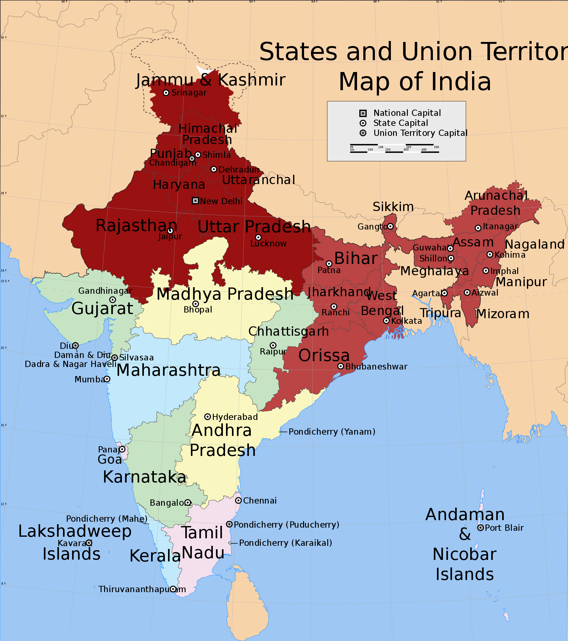
English: Shows in dark red the states listed at the time of creation: Jammu and Kashmir, Himachal Pradesh, Punjab, Haryana, Delhi, Rajasthan, Uttar Pradesh, Bihar, West Bengal, Orissa, Jharkhand, Sikkim, Assam, Meghalaya, Tripura, Nagaland, Manipur, Mizoram and Arunachal Pradesh.
Derived from India_states_and_union_territories_map.svg by changing the fill colour for those states. |
| วันที่ | Not known. Modified 31 กรกฎาคม พ.ศ. 2555 |
| แหล่งที่มา | File:India_states_and_union_territories_map.svg |
| ผู้สร้างสรรค์ | Whoever uploaded File:India_states_and_union_territories_map.svg to English Wikipedia |
| การอนุญาต (การใช้ไฟล์นี้ใหม่) |
http://en.wikipedia.org |
การอนุญาตใช้สิทธิ
ไฟล์นี้อยู่ภายใต้สัญญาอนุญาต ครีเอทีฟคอมมอนส์ แบบแสดงที่มา-อนุญาตแบบเดียวกัน 1.0 ทั่วไป
- คุณสามารถ:
- ที่จะแบ่งปัน – ที่จะทำสำเนา แจกจ่าย และส่งงานดังกล่าวต่อไป
- ที่จะเรียบเรียงใหม่ – ที่จะดัดแปลงงานดังกล่าว
- ภายใต้เงื่อนไขต่อไปนี้:
- แสดงที่มา – คุณต้องให้เกียรติเจ้าของงานอย่างเหมาะสม โดยเพิ่มลิงก์ไปยังสัญญาอนุญาต และระบุหากมีการเปลี่ยนแปลง คุณอาจทำเช่นนี้ได้ในรูปแบบใดก็ได้ตามควร แต่ต้องไม่ใช่ในลักษณะที่แนะว่าผู้ให้อนุญาตสนับสนุนคุณหรือการใช้งานของคุณ
- อนุญาตแบบเดียวกัน – If you alter, transform, or build upon this work, you must distribute the resulting work under the same license as the original.
บันทึกการอัพโหลด
นำเข้าจาก en.wikipedia มายังคอมมอนส์
The original description page was here. All following user names refer to en.wikipedia.
- 2012-07-31 20:55 Maproom 1639×1852× (309753 bytes) Added Uttaranchal to affected area, removed Assam and states south and east of it.
- 2012-07-31 17:29 Maproom 1639×1852× (309753 bytes) Uploading a file from a free published source using [[Wikipedia:File_Upload_Wizard|File Upload Wizard]]
The original description page was here. All following user names refer to en.wikipedia.
- 2012-08-01 15:07 Maproom 1639×1852× (309753 bytes) altered the status of (Bihar, West Bengal, Jharkhand, Orissa, Chhattisgarh) to 2nd-day only.
- 2012-08-01 08:12 Maproom 1639×1852× (309753 bytes) re-added the north-eastern states, in a lighter colour
- 2012-08-01 08:09 Maproom 1639×1852× (309753 bytes) re-added the north-eastern states, in a lighter colour
- 2012-07-31 20:55 Maproom 1639×1852× (309753 bytes) Added Uttaranchal to affected area, removed Assam and states south and east of it.
- 2012-07-31 17:29 Maproom 1639×1852× (309753 bytes) Uploading a file from a free published source using [[Wikipedia:File_Upload_Wizard|File Upload Wizard]]
ประวัติไฟล์
คลิกวันที่/เวลาเพื่อดูไฟล์ที่ปรากฏในขณะนั้น
| วันที่/เวลา | รูปย่อ | ขนาด | ผู้ใช้ | ความเห็น | |
|---|---|---|---|---|---|
| ปัจจุบัน | 22:17, 9 สิงหาคม 2555 | | 1,639 × 1,852 (302 กิโลไบต์) | Maproom | un-marked Chhattisgarh, in accordance with request at http://en.wikipedia.org/wiki/Wikipedia:WikiProject_Maps/Requested_and_orphan_maps |
| 00:34, 2 สิงหาคม 2555 |  | 1,639 × 1,852 (302 กิโลไบต์) | OgreBot | (BOT): Uploading old version of file from en.wikipedia; originally uploaded on 2012-08-01 15:07:18 by Maproom | |
| 00:33, 2 สิงหาคม 2555 |  | 1,639 × 1,852 (302 กิโลไบต์) | OgreBot | (BOT): Uploading old version of file from en.wikipedia; originally uploaded on 2012-08-01 08:09:17 by Maproom | |
| 00:33, 2 สิงหาคม 2555 |  | 1,639 × 1,852 (302 กิโลไบต์) | OgreBot | (BOT): Uploading old version of file from en.wikipedia; originally uploaded on 2012-07-31 17:29:42 by Maproom | |
| 11:36, 1 สิงหาคม 2555 |  | 1,639 × 1,852 (302 กิโลไบต์) | Makecat | {{Information |Description={{en|Shows in dark red the states listed at the time of creation: Jammu and Kashmir, Himachal Pradesh, Punjab, Haryana, Delhi, Rajasthan, Uttar Pradesh, Bihar, West Bengal, Orissa, Jharkhand, Sikkim, Assam, Meghalaya, Tripura... |
หน้าที่มีภาพนี้
หน้าต่อไปนี้ โยงมาที่ภาพนี้:
การใช้ไฟล์ข้ามโครงการ
วิกิอื่นต่อไปนี้ใช้ไฟล์นี้:
- การใช้บน af.wikipedia.org
- การใช้บน ar.wikipedia.org
- การใช้บน en.wikipedia.org
- การใช้บน es.wikipedia.org
- การใช้บน fr.wikipedia.org
- การใช้บน he.wikipedia.org
- การใช้บน ko.wikipedia.org
- การใช้บน lv.wikipedia.org
- การใช้บน pt.wikipedia.org
- การใช้บน ru.wikipedia.org
- การใช้บน ta.wikipedia.org
- การใช้บน vi.wikipedia.org
- การใช้บน zh.wikipedia.org