ไฟล์:Hong Kong 18-25 December 1941.png

ดูภาพที่มีความละเอียดสูงกว่า (1,855 × 1,293 พิกเซล, ขนาดไฟล์: 2.04 เมกะไบต์, ชนิดไมม์: image/png)
| รูปภาพหรือไฟล์เสียงนี้ ต้นฉบับอยู่ที่ คอมมอนส์ รายละเอียดด้านล่าง เป็นข้อความที่แสดงผลจาก ไฟล์ต้นฉบับในคอมมอนส์
|
ความย่อ
| คำอธิบาย |
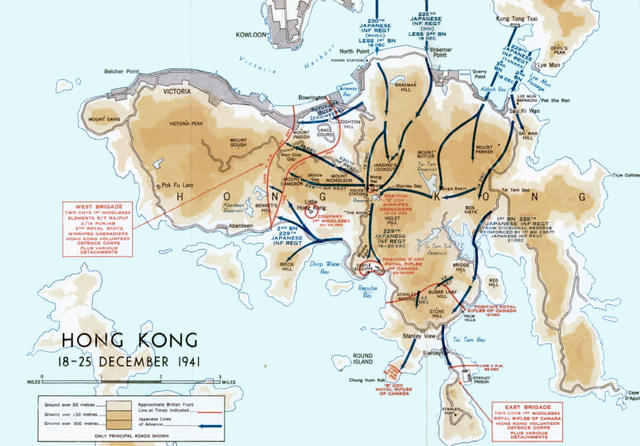
English: Colour map of the Japanese invasion of Hong Kong, December 1941 |
| วันที่ | |
| แหล่งที่มา | Stacey, C. P., maps drawn by C. C. J. Bond (1956) [1955]. Official History of the Canadian Army in the Second World War. Volume I: Six Year of War: The Army in Canada, Britain and the Pacific (PDF). (2nd rev. online ed.). Ottawa: By Authority of the Minister of National Defence. OCLC 917731527). Map compiled and drawn by Historical Section, General Staff, Canadian Army. |
| ผู้สร้างสรรค์ | C. C. J. Bond / Historical Section, General Staff, Canadian Army |
| เวอร์ชันอื่น |
 |
การอนุญาตใช้สิทธิ
This Canadian work is in the public domain in Canada because its copyright has expired due to one of the following:
it was not subject to Crown copyright, and
|
 |

|
This work may not be in the public domain in the United States because its U.S. copyright was restored by the URAA as it was still copyrighted in its source country on the URAA date (January 1, 1996 in most cases but see Wikipedia:Non-U.S. copyrights for details). In most cases, it is copyrighted in the U.S. until 95 years after the year in which it was initially published (exceptions are works published after 1977; see Commons:Hirtle chart). This template may not be used for files uploaded after 1 March 2012.
If you are the copyright holder of this file, and do not wish to have it hosted on Commons, please contact our designated agent or nominate the file for deletion, explaining the situation.
|
ประวัติไฟล์
คลิกวันที่/เวลาเพื่อดูไฟล์ที่ปรากฏในขณะนั้น
| วันที่/เวลา | รูปย่อ | ขนาด | ผู้ใช้ | ความเห็น | |
|---|---|---|---|---|---|
| ปัจจุบัน | 00:21, 8 เมษายน 2560 | | 1,855 × 1,293 (2.04 เมกะไบต์) | Hohum | Reworked |
| 23:34, 9 ตุลาคม 2559 |  | 1,855 × 1,293 (2.11 เมกะไบต์) | Hohum | Cleanup | |
| 06:46, 7 กันยายน 2559 |  | 1,855 × 1,293 (3.48 เมกะไบต์) | Keith-264 | User created page with UploadWizard |
หน้าที่มีภาพนี้
หน้าต่อไปนี้ โยงมาที่ภาพนี้:
การใช้ไฟล์ข้ามโครงการ
วิกิอื่นต่อไปนี้ใช้ไฟล์นี้:
- การใช้บน azb.wikipedia.org
- การใช้บน en.wikipedia.org
- การใช้บน es.wikipedia.org
- การใช้บน fr.wikipedia.org
- การใช้บน sr.wikipedia.org