ไฟล์:Hawaje-NoRedLine.jpg

ดูภาพที่มีความละเอียดสูงกว่า (3,600 × 2,800 พิกเซล, ขนาดไฟล์: 2.81 เมกะไบต์, ชนิดไมม์: image/jpeg)
| รูปภาพหรือไฟล์เสียงนี้ ต้นฉบับอยู่ที่ คอมมอนส์ รายละเอียดด้านล่าง เป็นข้อความที่แสดงผลจาก ไฟล์ต้นฉบับในคอมมอนส์
|
ความย่อ
| คำอธิบาย |
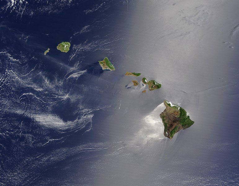
Čeština: Satelitní pohled na Havajské ostrovy
English: Satellite view of Hawaii archipelago (USA) Original description from NASA:
Français : Vue satellite de l'archipel d'Hawaï (États-Unis) |
| วันที่ | |
| แหล่งที่มา |
|
| ผู้สร้างสรรค์ | Jacques Descloitres |
| เวอร์ชันอื่น |
 |
| ภาพนี้ ได้รับการปรับแต่งภาพ ซึ่งหมายความว่าจะได้รับการเปลี่ยนแปลงภาพต่างจากต้นฉบับ การปรับปรุง: cloned out and healed little red line on the big island. ต้นฉบับสามารถดูได้ที่นี่: Hawaje.jpg. ปรับแต่งภาพโดย IdLoveOne.
|
การอนุญาตใช้สิทธิ
| ภาพนี้เป็นสาธารณสมบัติ เนื่องจากเป็นภาพที่สร้างขึ้นโดยองค์การบริหารการบินและอวกาศแห่งชาติ (NASA) ซึ่งตามนโยบายด้านลิขสิทธิ์ของนาซาระบุไว้ว่า "ภาพและสื่อต่าง ๆ ของนาซาไม่ได้รับการคุ้มครองโดยลิขสิทธิ์ยกเว้นจะระบุไว้ว่ามีลิขสิทธิ์" ดูเพิ่มที่ หน้านโยบายด้านลิขสิทธิ์ของนาซา หรือ นโยบายการใช้ภาพของ JPL | ||
 |
คำเตือน:
|
บันทึกการอัพโหลด
This file was derived from: Hawaje.jpg
- File:Hawaje.jpg licensed with PD-USGov-NASA
- 2005-10-26T18:19:43Z Palladinus 3600x2800 (1211908 Bytes) Hawaii Islands
Uploaded with derivativeFX
Assessment
|
ภาพนี้ได้รับการคัดสรรให้เป็น ภาพประจำวัน สำหรับวันที่ 16 มิถุนายน พ.ศ. 2554 ภาพดังกล่าวมีคำอธิบายดังต่อไปนี้: ภาษาอื่น ๆ:
Čeština: Satelitní pohled na Havajské ostrovy Eesti: Hawaii saared satelliidifotol. Magyar: Hawaii szigetvilágának műholdas képe Português: Texto de cabeçalho. Русский: Спутниковая фотография Гавайских островов 한국어: 하와이 제도의 위성 사진. 日本語: ハワイ諸島の衛星写真 中文: 美国夏威夷的卫星照片 |
ประวัติไฟล์
คลิกวันที่/เวลาเพื่อดูไฟล์ที่ปรากฏในขณะนั้น
| วันที่/เวลา | รูปย่อ | ขนาด | ผู้ใช้ | ความเห็น | |
|---|---|---|---|---|---|
| ปัจจุบัน | 05:24, 2 กันยายน 2553 | | 3,600 × 2,800 (2.81 เมกะไบต์) | IdLoveOne~commonswiki | {{RetouchedPicture|cloned out and healed little red line on the big island|editor=IdLoveOne|orig=Hawaje.jpg}} {{self|PD-USGov-NASA}} == {{Original upload log}} == This image is a derivative work of the following images: *File:Hawaje.jpg licensed w |
หน้าที่มีภาพนี้
หน้าต่อไปนี้ โยงมาที่ภาพนี้:
การใช้ไฟล์ข้ามโครงการ
วิกิอื่นต่อไปนี้ใช้ไฟล์นี้:
- การใช้บน ace.wikipedia.org
- การใช้บน af.wikipedia.org
- การใช้บน als.wikipedia.org
- การใช้บน ar.wikipedia.org
- การใช้บน ary.wikipedia.org
- การใช้บน arz.wikipedia.org
- การใช้บน ast.wikipedia.org
- การใช้บน azb.wikipedia.org
- การใช้บน az.wikipedia.org
- การใช้บน ba.wikipedia.org
- การใช้บน be-tarask.wikipedia.org
- การใช้บน bh.wikipedia.org
- การใช้บน bn.wikipedia.org
- การใช้บน bn.wikibooks.org
- การใช้บน ca.wikipedia.org
- การใช้บน ceb.wikipedia.org
- การใช้บน crh.wikipedia.org
- การใช้บน cs.wikipedia.org
- การใช้บน cv.wikipedia.org
- การใช้บน cy.wikipedia.org
- การใช้บน dag.wikipedia.org
- การใช้บน de.wikipedia.org
- การใช้บน diq.wikipedia.org
- การใช้บน el.wikipedia.org
- การใช้บน en.wikipedia.org
ดูการใช้ข้ามโครงการเพิ่มเติมของไฟล์นี้