ไฟล์:Guadiana Mouth.jpg
ขนาดของตัวอย่างนี้: 800 × 600 พิกเซล ความละเอียดอื่น: 320 × 240 พิกเซล | 640 × 480 พิกเซล | 1,024 × 768 พิกเซล | 1,280 × 960 พิกเซล | 1,600 × 1,200 พิกเซล
ดูภาพที่มีความละเอียดสูงกว่า (1,600 × 1,200 พิกเซล, ขนาดไฟล์: 303 กิโลไบต์, ชนิดไมม์: image/jpeg)
| รูปภาพหรือไฟล์เสียงนี้ ต้นฉบับอยู่ที่ คอมมอนส์ รายละเอียดด้านล่าง เป็นข้อความที่แสดงผลจาก ไฟล์ต้นฉบับในคอมมอนส์
|
ความย่อ
| คำอธิบาย |
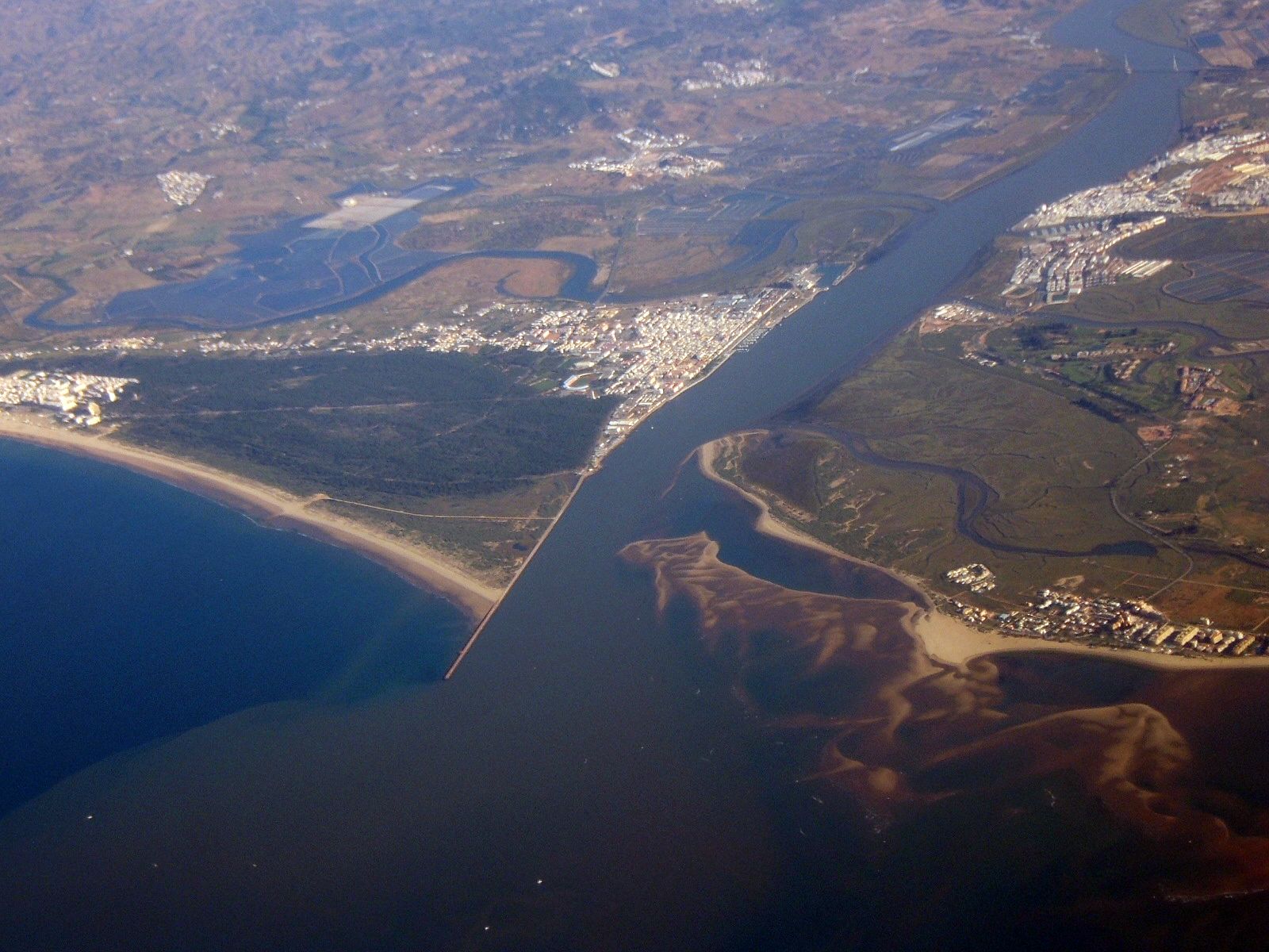
English: Aerial view of the mouth of the Guadiana (Español), Guadiana (Português), Guadiana (English) river flowing into the Atlantic Ocean. Portugal is on the left side of the image; Spain on the right side.
The Portuguese town in the center of the image is Vila Real de Santo António, the Spanish town further north is Ayamonte. The small Spanish village at the sea is Isla Canela, the Portuguese coastal village on the very left is Monte Gordo. The village north of Monte Gordo is Três Azeitonas and the village north of Vila Real is Castro Marim, further north, Monte Francisco can be seen. At extreme top right, the Puente Internacional cable-stayed bridge can be seen. Español: Vista aérea de la desembocadura del río Guadiana. En la fotografía se aprecian las localidades portuguesa de Villa Real (izquierda) y española de Ayamonte (derecha). En la margen portuguesa se aprecian otras localidades menores como Três Azeitonas, Castro Marim o Monte Gordo, y en la española se observa al sur Isla Canela. Río arriba se puede apreciar el puente internacional. El conjunto está dominado por las marismas de Isla Cristina en el lado español y por el Sapal de Castro Marim en el portugués. |
| วันที่ | |
| แหล่งที่มา | งานของตัว |
| ผู้สร้างสรรค์ | Toksave |
การอนุญาตใช้สิทธิ
I, Toksave ในฐานะผู้ถือลิขสิทธิ์ของภาพหรือสื่อนี้ อนุญาตให้ใช้ภาพหรือสื่อนี้ภายใต้เงื่อนไขต่อไปนี้

|
อนุญาตให้คัดลอก แจกจ่ายและ/หรือดัดแปรเอกสารนี้ภายใต้เงื่อนไขของสัญญาอนุญาตเอกสารเสรีของกนู รุ่น 1.2 หรือรุ่นใด ๆ นับจากนี้ที่ออกโดยมูลนิธิซอฟต์แวร์เสรี โดยไม่มีส่วนใดห้ามแก้ไข ไม่มีข้อความปกหน้าและปกหลัง สำเนาของสัญญาอนุญาตรวมอยู่ในส่วนชื่อ สัญญาอนุญาตเอกสารเสรีของกนู |
| ไฟล์นี้อยู่ภายใต้สัญญาอนุญาต ครีเอทีฟคอมมอนส์ แบบแสดงที่มา-อนุญาตแบบเดียวกัน 3.0 ต้นฉบับ | ||
| การแสดงที่มา: I, Toksave | ||
| ||
| ป้ายแสดงสถานะลิขสิทธิ์นี้ถูกเพิ่มเพื่อให้เป็นไปตามการเปลี่ยนแปลงสัญญาอนุญาตของมูลนิธิวิกิมีเดีย จาก GFDL ไปยัง GFDL ควบคู่กับ CC-BY-SA 3.0 |
ไฟล์นี้อยู่ภายใต้สัญญาอนุญาตครีเอทีฟคอมมอนส์ รุ่นแสดงที่มา-อนุญาตแบบเดียวกัน 2.5 ทั่วไป, 2.0 ทั่วไป และ 1.0 ทั่วไป
การแสดงที่มา: I, Toksave
- คุณสามารถ:
- ที่จะแบ่งปัน – ที่จะทำสำเนา แจกจ่าย และส่งงานดังกล่าวต่อไป
- ที่จะเรียบเรียงใหม่ – ที่จะดัดแปลงงานดังกล่าว
- ภายใต้เงื่อนไขต่อไปนี้:
- แสดงที่มา – คุณต้องให้เกียรติเจ้าของงานอย่างเหมาะสม โดยเพิ่มลิงก์ไปยังสัญญาอนุญาต และระบุหากมีการเปลี่ยนแปลง คุณอาจทำเช่นนี้ได้ในรูปแบบใดก็ได้ตามควร แต่ต้องไม่ใช่ในลักษณะที่แนะว่าผู้ให้อนุญาตสนับสนุนคุณหรือการใช้งานของคุณ
- อนุญาตแบบเดียวกัน – หากคุณดัดแปลง เปลี่ยนรูป หรือต่อเติมงานนี้ คุณต้องใช้สัญญาอนุญาตแบบเดียวกันหรือแบบที่เหมือนกับสัญญาอนุญาตที่ใช้กับงานนี้เท่านั้น
คุณสามารถเลือกสัญญาอนุญาตดังกล่าวตามต้องการ
ประวัติไฟล์
คลิกวันที่/เวลาเพื่อดูไฟล์ที่ปรากฏในขณะนั้น
| วันที่/เวลา | รูปย่อ | ขนาด | ผู้ใช้ | ความเห็น | |
|---|---|---|---|---|---|
| ปัจจุบัน | 16:20, 15 มิถุนายน 2550 | | 1,600 × 1,200 (303 กิโลไบต์) | Toksave | {{Information |Description= Mouth of the Guadiana River in the Mediterranean Sea, Portugal is on the left side, Spain on the right side of the river. The portuguese town in the center of the image is Vila Real de Santo António, the spanish town further n |
หน้าที่มีภาพนี้
หน้าต่อไปนี้ โยงมาที่ภาพนี้:
การใช้ไฟล์ข้ามโครงการ
วิกิอื่นต่อไปนี้ใช้ไฟล์นี้:
- การใช้บน ca.wikipedia.org
- การใช้บน cv.wikipedia.org
- การใช้บน da.wikipedia.org
- การใช้บน de.wikipedia.org
- การใช้บน de.wikivoyage.org
- การใช้บน en.wikipedia.org
- การใช้บน eo.wikipedia.org
- การใช้บน es.wikipedia.org
- การใช้บน eu.wikipedia.org
- การใช้บน fr.wikipedia.org
- การใช้บน fy.wikipedia.org
- การใช้บน gl.wikipedia.org
- การใช้บน he.wikipedia.org
- การใช้บน hu.wikipedia.org
- การใช้บน it.wikipedia.org
- การใช้บน it.wikivoyage.org
- การใช้บน ja.wikipedia.org
- การใช้บน ko.wikipedia.org
- การใช้บน lt.wikipedia.org
- การใช้บน mk.wikipedia.org
- การใช้บน mwl.wikipedia.org
- การใช้บน nn.wikipedia.org
- การใช้บน no.wikipedia.org
- การใช้บน pl.wikipedia.org
- การใช้บน pt.wikipedia.org
- การใช้บน ru.wikipedia.org
- การใช้บน simple.wikipedia.org
- การใช้บน tt.wikipedia.org
- การใช้บน www.wikidata.org
ดูการใช้ข้ามโครงการเพิ่มเติมของไฟล์นี้