ไฟล์:European railtrafficregions.png
ขนาดของตัวอย่างนี้: 683 × 599 พิกเซล ความละเอียดอื่น: 274 × 240 พิกเซล | 547 × 480 พิกเซล | 891 × 782 พิกเซล
ดูภาพที่มีความละเอียดสูงกว่า (891 × 782 พิกเซล, ขนาดไฟล์: 28 กิโลไบต์, ชนิดไมม์: image/png)
| รูปภาพหรือไฟล์เสียงนี้ ต้นฉบับอยู่ที่ คอมมอนส์ รายละเอียดด้านล่าง เป็นข้อความที่แสดงผลจาก ไฟล์ต้นฉบับในคอมมอนส์
|
| คำอธิบาย |
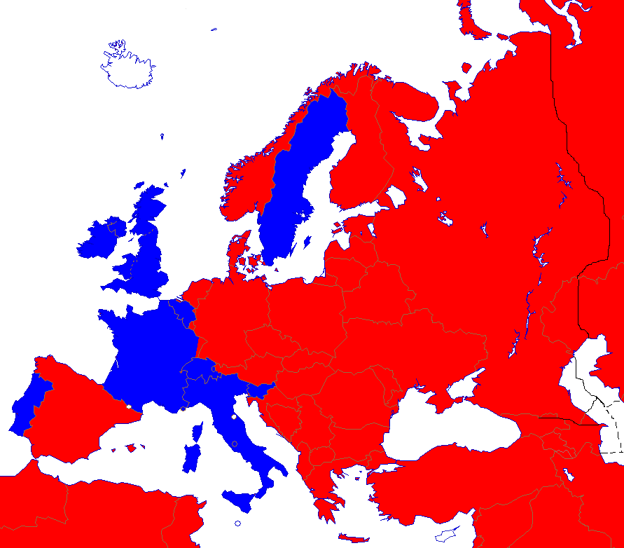
English: Right- and left-hand traffic on European railways.
Right-hand traffic Left-hand traffic No railway Svenska: Höger- och vänstertrafik på järnvägar i Europa. Högertrafik Vänstertrafik Inga järnvägar |
||||||||
| วันที่ | |||||||||
| แหล่งที่มา | Wikipedia | ||||||||
| ผู้สร้างสรรค์ | Paul Schlyter | ||||||||
| การอนุญาต (การใช้ไฟล์นี้ใหม่) |
|
||||||||
| เวอร์ชันอื่น |
File:European_trafficregions.png |


|
ภาพ map of europe นี้ ควรจะถูกสร้างใหม่เป็นกราฟิกส์เวกเตอร์ ซึ่งมีข้อดีอีกหลายประการ ดูเพิ่มเติมที่คอมมอนส์:สื่อต้องการเก็บกวาดสำหรับสารสนเทศเพิ่มเติม หากภาพนี้มีในรูปแบบกราฟิกส์เวกเตอร์อยู่แล้ว กรุณาอัปโหลดและแทนที่แม่แบบนี้ด้วย
{{vector version available|ชื่อภาพใหม่}}
แนะนำเป็นอย่างยิ่งให้ตั้งชื่อไฟล์เวกเตอร์ใหม่นั้นในรูปแบบ "European railtrafficregions.svg" แล้วใส่แม่แบบ Vector version available (หรือ Vva) ซึ่งไม่ต้องใช้พารามิเตอร์ ชื่อภาพใหม่ |
ประวัติไฟล์
คลิกวันที่/เวลาเพื่อดูไฟล์ที่ปรากฏในขณะนั้น
| วันที่/เวลา | รูปย่อ | ขนาด | ผู้ใช้ | ความเห็น | |
|---|---|---|---|---|---|
| ปัจจุบัน | 05:06, 24 สิงหาคม 2565 | | 891 × 782 (28 กิโลไบต์) | Рагин1987 | More correct visualization of the dividing line on the territory of the Caucasus Range |
| 23:24, 15 ธันวาคม 2560 |  | 891 × 782 (44 กิโลไบต์) | A2D2 | The Vatican city has railways and uses the left just like Italy, even though it is only a few hundred meters long and is very rarely used. | |
| 03:30, 19 มกราคม 2560 |  | 891 × 782 (44 กิโลไบต์) | BIL | Spain uses right. Austria also to much higher degree since 2012. Monaco uses left. A corner of France and Sweden diverge use their neighbour's side. Channel tunnel and Oresund Bridge added. Slightly cropped so that Svalbard and Turkmenistan are excluded. | |
| 21:22, 1 กันยายน 2551 |  | 942 × 917 (44 กิโลไบต์) | Pausch | {{Information/sv |Beskrivning = Höger/vänstertrafik på järnvägar i Europa |Källa = Wikipedia |Datum = 2008-09-01 |Skapare = Paul Schlyter |Rättigheter = GFDL |Andra_versioner = European_trafficregions.png }} Category:Järnvägar <!--{{ImageUpl |
หน้าที่มีภาพนี้
ไม่มีหน้าใดโยงมาที่ภาพนี้
การใช้ไฟล์ข้ามโครงการ
วิกิอื่นต่อไปนี้ใช้ไฟล์นี้:
- การใช้บน en.wikipedia.org
- การใช้บน es.wikipedia.org
- การใช้บน et.wikipedia.org
- การใช้บน hu.wikipedia.org
- การใช้บน id.wikipedia.org
- การใช้บน mk.wikipedia.org
- การใช้บน no.wikipedia.org
- การใช้บน ru.wikipedia.org
- การใช้บน sv.wikipedia.org
- การใช้บน www.wikidata.org