ไฟล์:Europe 1783-1792 en.png

ขนาดของตัวอย่างนี้: 800 × 570 พิกเซล ความละเอียดอื่น: 320 × 228 พิกเซล | 640 × 456 พิกเซล | 1,024 × 730 พิกเซล | 1,280 × 913 พิกเซล | 2,560 × 1,825 พิกเซล | 3,872 × 2,761 พิกเซล
ดูภาพที่มีความละเอียดสูงกว่า (3,872 × 2,761 พิกเซล, ขนาดไฟล์: 1.24 เมกะไบต์, ชนิดไมม์: image/png)
| รูปภาพหรือไฟล์เสียงนี้ ต้นฉบับอยู่ที่ คอมมอนส์ รายละเอียดด้านล่าง เป็นข้อความที่แสดงผลจาก ไฟล์ต้นฉบับในคอมมอนส์
|
_en.png)
.png)
.jpg)
ความย่อ
| คำอธิบาย |
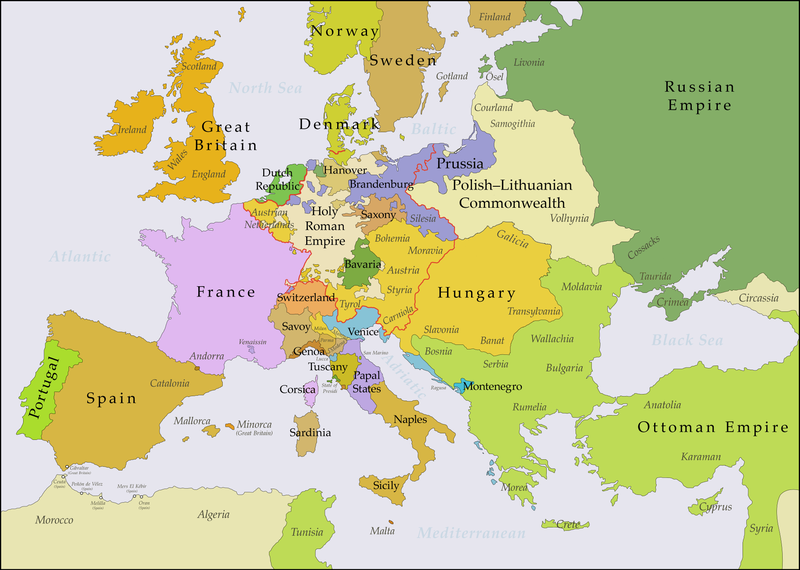
English: This map shows Europe in the years between the 1783 Russian annexation of Crimea after the Russo-Turkish War of 1768–1774 and the Russian annexation of Yedisan in 1792 at the end of the Russo-Turkish War of 1787–1792. The red line marks the borders of the Holy Roman Empire. The work was created with Inkscape and is mainly based on a map in: Putzger - Historischer Weltatlas, Berlin 1990, 78 pp. |
| วันที่ | |
| แหล่งที่มา | งานของตัว, based on File:Europe 1748-1766 en.png |
| ผู้สร้างสรรค์ | Bryan Rutherford |
การอนุญาตใช้สิทธิ
ข้าพเจ้า ในฐานะผู้ถือลิขสิทธิ์ของภาพหรือสื่อนี้ อนุญาตให้ใช้ภาพหรือสื่อนี้ภายใต้เงื่อนไขต่อไปนี้
ไฟล์นี้อยู่ภายใต้สัญญาอนุญาต ครีเอทีฟคอมมอนส์ แบบแสดงที่มา-อนุญาตแบบเดียวกัน 4.0 นานาชาติ
- คุณสามารถ:
- ที่จะแบ่งปัน – ที่จะทำสำเนา แจกจ่าย และส่งงานดังกล่าวต่อไป
- ที่จะเรียบเรียงใหม่ – ที่จะดัดแปลงงานดังกล่าว
- ภายใต้เงื่อนไขต่อไปนี้:
- แสดงที่มา – คุณต้องให้เกียรติเจ้าของงานอย่างเหมาะสม โดยเพิ่มลิงก์ไปยังสัญญาอนุญาต และระบุหากมีการเปลี่ยนแปลง คุณอาจทำเช่นนี้ได้ในรูปแบบใดก็ได้ตามควร แต่ต้องไม่ใช่ในลักษณะที่แนะว่าผู้ให้อนุญาตสนับสนุนคุณหรือการใช้งานของคุณ
- อนุญาตแบบเดียวกัน – หากคุณดัดแปลง เปลี่ยนรูป หรือต่อเติมงานนี้ คุณต้องใช้สัญญาอนุญาตแบบเดียวกันหรือแบบที่เหมือนกับสัญญาอนุญาตที่ใช้กับงานนี้เท่านั้น
| Annotations | This image is annotated: View the annotations at Commons |
ประวัติไฟล์
คลิกวันที่/เวลาเพื่อดูไฟล์ที่ปรากฏในขณะนั้น
| วันที่/เวลา | รูปย่อ | ขนาด | ผู้ใช้ | ความเห็น | |
|---|---|---|---|---|---|
| ปัจจุบัน | 04:47, 16 กรกฎาคม 2561 | | 3,872 × 2,761 (1.24 เมกะไบต์) | Bryanrutherford0 | Added the Ionian Islands, made the Duchy of Milan a Habsburg possession, gave Prussia control of Mansfeld (1780) |
| 09:29, 10 กรกฎาคม 2561 |  | 3,872 × 2,761 (1.23 เมกะไบต์) | Bryanrutherford0 | Added Comtat Venaissin and redrew borders of Neuchâtel, Bishopric Basel, and Montbéliard | |
| 07:46, 3 ตุลาคม 2560 |  | 3,872 × 2,761 (1.23 เมกะไบต์) | Bryanrutherford0 | Transferred control of Saaremaa and Hiiumaa to Russia (1721 Treaty of Nystad), transferred control of Corsica to France (1769 [[:en:French conquest of Corsica|French conquest of... | |
| 22:03, 30 กันยายน 2560 |  | 3,872 × 2,761 (1.23 เมกะไบต์) | Bryanrutherford0 | Adjusted Russian-Swedish border in Finland to reflect Russian gains in the 1743 Treaty of Åbo after the Russo-Swedish War. | |
| 11:47, 30 กันยายน 2560 |  | 3,872 × 2,761 (1.23 เมกะไบต์) | Bryanrutherford0 | User created page with UploadWizard |
หน้าที่มีภาพนี้
หน้าต่อไปนี้ โยงมาที่ภาพนี้:
การใช้ไฟล์ข้ามโครงการ
วิกิอื่นต่อไปนี้ใช้ไฟล์นี้:
- การใช้บน ar.wikipedia.org
- การใช้บน bg.wikipedia.org
- การใช้บน bn.wikipedia.org
- การใช้บน br.wikipedia.org
- การใช้บน ca.wikipedia.org
- การใช้บน el.wikipedia.org
- การใช้บน en.wikipedia.org
- การใช้บน es.wikipedia.org
- การใช้บน fi.wikipedia.org
- การใช้บน fr.wikipedia.org
- การใช้บน it.wikipedia.org
- การใช้บน ja.wikipedia.org
- การใช้บน ka.wikipedia.org
- การใช้บน mk.wikipedia.org
- การใช้บน sl.wikipedia.org
- การใช้บน tl.wikipedia.org
- การใช้บน uz.wikipedia.org
- การใช้บน vi.wikipedia.org
- การใช้บน zh.wikipedia.org