ไฟล์:ElectoralCollege2016.svg

ขนาดของตัวอย่าง PNG นี้ของไฟล์ SVG นี้: 800 × 465 พิกเซล ความละเอียดอื่น: 320 × 186 พิกเซล | 640 × 372 พิกเซล | 1,024 × 595 พิกเซล | 1,280 × 744 พิกเซล | 2,560 × 1,488 พิกเซล | 1,020 × 593 พิกเซล
ดูภาพที่มีความละเอียดสูงกว่า ((ไฟล์ SVG, 1,020 × 593 พิกเซล, ขนาดไฟล์: 30 กิโลไบต์))
| รูปภาพหรือไฟล์เสียงนี้ ต้นฉบับอยู่ที่ คอมมอนส์ รายละเอียดด้านล่าง เป็นข้อความที่แสดงผลจาก ไฟล์ต้นฉบับในคอมมอนส์
|
| U.S. presidential election maps (SVG) |
| See also: National Atlas maps (png) |
|
1789 · 1792 · 1796 · 1800 · 1804 · 1808 · 1812 · 1816 · 1820 · 1824 · 1828 · 1832 · 1836 · 1840 · 1844 · 1848 · 1852 · 1856 · 1860 · 1864 · 1868 · 1872 · 1876 · 1880 · 1884 · 1888 · 1892 · 1896 · 1900 · 1904 · 1908 · 1912 · 1916 · 1920 · 1924 · 1928 · 1932 · 1936 · 1940 · 1944 · 1948 · 1952 · 1956 · 1960 · 1964 · 1968 · 1972 · 1976 · 1980 · 1984 · 1988 · 1992 · 1996 · 2000 · 2004 · 2008 · 2012 · 2016 · 2020 · 2024 |
ความย่อ
| คำอธิบาย |
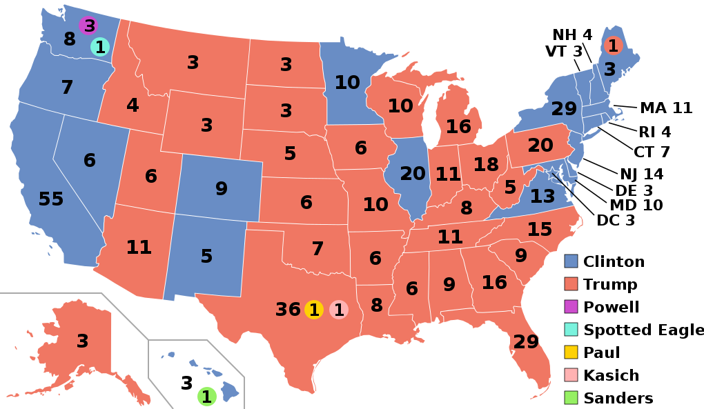
English: Electoral college map for the 2016 United States presidential election (note: Nebraska and Maine split their EVs by congressional district). |
||||
| วันที่ | |||||
| แหล่งที่มา | 2012 Electoral College map | ||||
| ผู้สร้างสรรค์ | Gage | ||||
| เวอร์ชันอื่น |
|
||||
| SVG genesis | ซอร์สโค้ดของ SVG นี้ตรวจสอบถูกต้องแล้ว . ไฟล์ภาพเวกเตอร์นี้ สร้างขึ้นโดยใช้โปรแกรมแก้ไขข้อความ This map uses embedded text. |

.svg)


.svg)
.svg)


การอนุญาตใช้สิทธิ
ไฟล์นี้อยู่ภายใต้สัญญาอนุญาต ครีเอทีฟคอมมอนส์ แบบแสดงที่มา-อนุญาตแบบเดียวกัน 4.0 นานาชาติ
- คุณสามารถ:
- ที่จะแบ่งปัน – ที่จะทำสำเนา แจกจ่าย และส่งงานดังกล่าวต่อไป
- ที่จะเรียบเรียงใหม่ – ที่จะดัดแปลงงานดังกล่าว
- ภายใต้เงื่อนไขต่อไปนี้:
- แสดงที่มา – คุณต้องให้เกียรติเจ้าของงานอย่างเหมาะสม โดยเพิ่มลิงก์ไปยังสัญญาอนุญาต และระบุหากมีการเปลี่ยนแปลง คุณอาจทำเช่นนี้ได้ในรูปแบบใดก็ได้ตามควร แต่ต้องไม่ใช่ในลักษณะที่แนะว่าผู้ให้อนุญาตสนับสนุนคุณหรือการใช้งานของคุณ
- อนุญาตแบบเดียวกัน – หากคุณดัดแปลง เปลี่ยนรูป หรือต่อเติมงานนี้ คุณต้องใช้สัญญาอนุญาตแบบเดียวกันหรือแบบที่เหมือนกับสัญญาอนุญาตที่ใช้กับงานนี้เท่านั้น
ประวัติไฟล์
คลิกวันที่/เวลาเพื่อดูไฟล์ที่ปรากฏในขณะนั้น
| วันที่/เวลา | รูปย่อ | ขนาด | ผู้ใช้ | ความเห็น | |
|---|---|---|---|---|---|
| ปัจจุบัน | 10:22, 27 พฤศจิกายน 2563 | | 1,020 × 593 (30 กิโลไบต์) | Politicsfan4 | Updated placement of ME-2's electoral vote for consistency with 2020 map |
| 08:22, 5 สิงหาคม 2563 |  | 1,020 × 593 (30 กิโลไบต์) | Nojus R | Reverted to version as of 07:42, 13 January 2019 (UTC) it looks so weird when every other map uses a different font | |
| 02:31, 11 ธันวาคม 2562 |  | 1,020 × 593 (30 กิโลไบต์) | IagoQnsi | switching font to Arial, as it looks less-ugly in the server-side rendering // Editing SVG source code using c:User:Rillke/SVGedit.js | |
| 14:42, 13 มกราคม 2562 |  | 1,020 × 593 (30 กิโลไบต์) | Newfraferz87 | (minor) | |
| 09:50, 20 พฤศจิกายน 2561 |  | 1,020 × 593 (30 กิโลไบต์) | Newfraferz87 | *DC | |
| 09:35, 20 พฤศจิกายน 2561 |  | 1,020 × 593 (30 กิโลไบต์) | Newfraferz87 | Simplify further: coordinates & fills, following this | |
| 21:16, 18 มกราคม 2560 |  | 1,020 × 593 (36 กิโลไบต์) | Newfraferz87 | Shrink size using relative line coordinates. Thanks for the border corrections. | |
| 16:20, 17 มกราคม 2560 |  | 1,020 × 593 (43 กิโลไบต์) | Karlfk | Better borderlines, esp. OH/WV/PA triangle or ID/MT border | |
| 10:14, 12 มกราคม 2560 |  | 1,020 × 593 (36 กิโลไบต์) | PalmerTheGolfer | Reverted to version as of 00:56, 3 January 2017 (UTC) Font of numbers and State line consistency with prior elections more important than a non-existent Libretarian faithless elector change | |
| 05:50, 11 มกราคม 2560 |  | 1,020 × 593 (36 กิโลไบต์) | Maproom | Changed font to Liberation Sans, in the hope of avoiding the problem of "Eagle" extending off the end of the image |
.svg)
หน้าที่มีภาพนี้
หน้าต่อไปนี้ โยงมาที่ภาพนี้:
การใช้ไฟล์ข้ามโครงการ
วิกิอื่นต่อไปนี้ใช้ไฟล์นี้:
- การใช้บน af.wikipedia.org
- การใช้บน ang.wikipedia.org
- การใช้บน ar.wikipedia.org
- การใช้บน arz.wikipedia.org
- การใช้บน be.wikipedia.org
- การใช้บน bg.wikipedia.org
- การใช้บน bn.wikipedia.org
- การใช้บน bs.wikipedia.org
- การใช้บน ca.wikipedia.org
- การใช้บน cdo.wikipedia.org
- การใช้บน cs.wikipedia.org
- การใช้บน cy.wikipedia.org
- การใช้บน da.wikipedia.org
- การใช้บน de.wikipedia.org
- การใช้บน dty.wikipedia.org
- การใช้บน el.wikipedia.org
- การใช้บน en.wikipedia.org
- Donald Trump
- Electoral vote changes between United States presidential elections
- List of United States presidential election results by state
- Presidency of Barack Obama
- 2016 United States presidential election
- United States presidential election
- 2016 Democratic Party presidential candidates
- 2016 Democratic Party presidential primaries
- 2016 Republican Party presidential candidates
- 2016 Republican Party presidential primaries
- Third party and independent candidates for the 2016 United States presidential election
- 2016 United States elections
- User:ArcMachaon/sandbox
- User:Mandruss/sandbox
- User:Visigoethe/sandbox
- User:Machinekng/sandbox
ดูการใช้ข้ามโครงการเพิ่มเติมของไฟล์นี้