ไฟล์:Dead-Sea---Salt-Evaporation-Ponds.jpg
ขนาดของตัวอย่างนี้: 525 × 599 พิกเซล ความละเอียดอื่น: 210 × 240 พิกเซล | 421 × 480 พิกเซล | 673 × 768 พิกเซล | 1,057 × 1,206 พิกเซล
ดูภาพที่มีความละเอียดสูงกว่า (1,057 × 1,206 พิกเซล, ขนาดไฟล์: 518 กิโลไบต์, ชนิดไมม์: image/jpeg)
| รูปภาพหรือไฟล์เสียงนี้ ต้นฉบับอยู่ที่ คอมมอนส์ รายละเอียดด้านล่าง เป็นข้อความที่แสดงผลจาก ไฟล์ต้นฉบับในคอมมอนส์
|
ความย่อ
| คำอธิบาย |
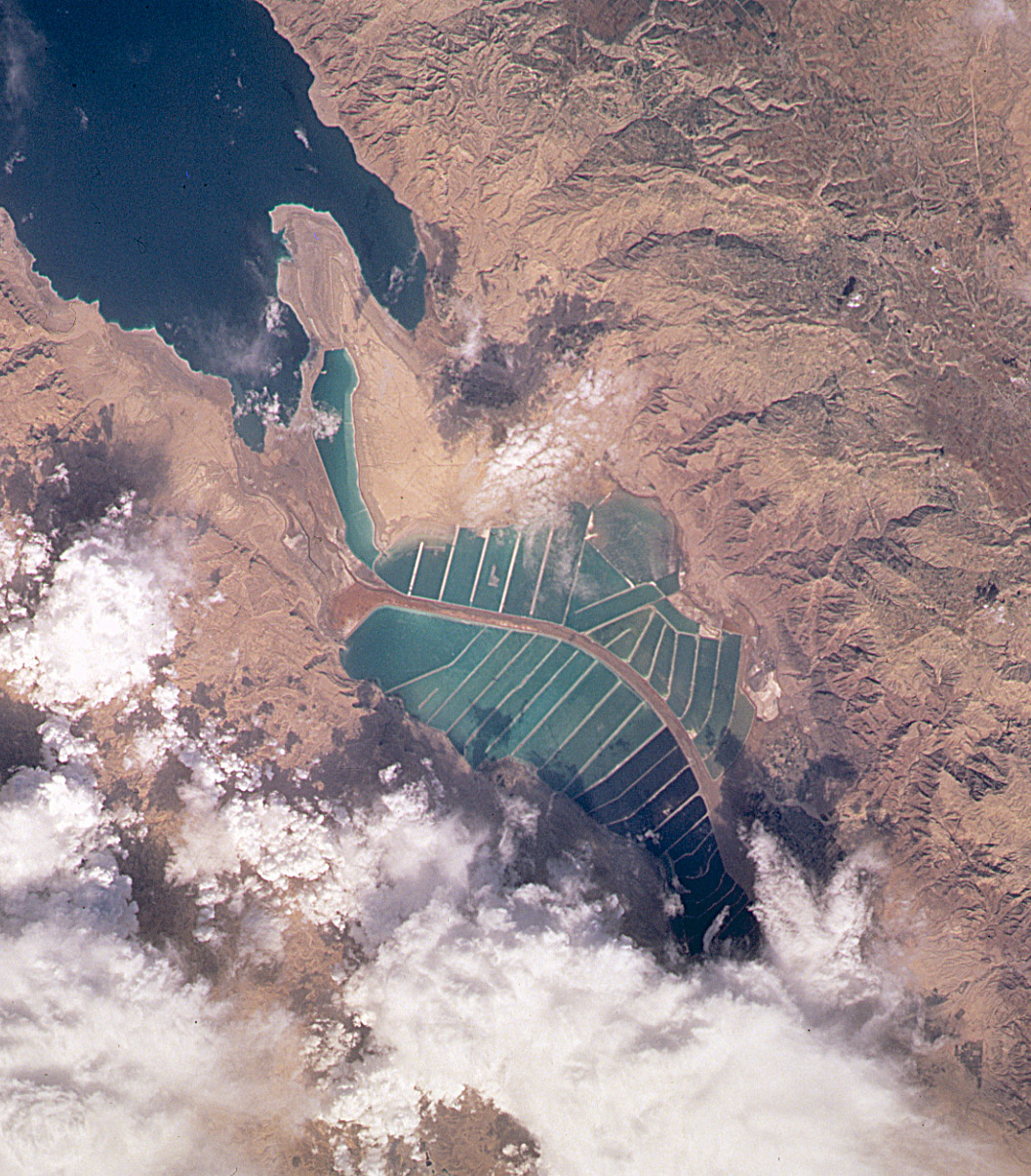
English: Orbital image of Jordanian and Israeli mineral evaporation ponds at the south end of the Dead Sea, separated by a central dike that runs roughly north-south along the international border. |
| แหล่งที่มา | http://visibleearth.nasa.gov/cgi-bin/viewrecord?7875 |
| ผู้สร้างสรรค์ | Image taken from the space shuttle by the STS102 crew in March 2001. |
Captioned As
| Page | Caption |
|---|---|
| Dead Sea | View of the mineral evaporation ponds almost 12 years later (STS-102). A northern and small southeastern extension were added and the large polygonal ponds subdivided. |
การอนุญาตใช้สิทธิ
| ภาพนี้เป็นสาธารณสมบัติ เนื่องจากเป็นภาพที่สร้างขึ้นโดยองค์การบริหารการบินและอวกาศแห่งชาติ (NASA) ซึ่งตามนโยบายด้านลิขสิทธิ์ของนาซาระบุไว้ว่า "ภาพและสื่อต่าง ๆ ของนาซาไม่ได้รับการคุ้มครองโดยลิขสิทธิ์ยกเว้นจะระบุไว้ว่ามีลิขสิทธิ์" ดูเพิ่มที่ หน้านโยบายด้านลิขสิทธิ์ของนาซา หรือ นโยบายการใช้ภาพของ JPL | ||
 |
คำเตือน:
|
บันทึกการอัพโหลด
The original description page was here. All following user names refer to en.wikipedia.
| วันที่/เวลา | ขนาด | ผู้ใช้ | ความเห็น |
|---|---|---|---|
| 2004-10-10 19:45 | 1057×1206× (530534 bytes) | Solipsist | Satelite image of [[Jordan]]ian salt evaporation ponds at the south end of the [[Dead Sea]] |
ประวัติไฟล์
คลิกวันที่/เวลาเพื่อดูไฟล์ที่ปรากฏในขณะนั้น
| วันที่/เวลา | รูปย่อ | ขนาด | ผู้ใช้ | ความเห็น | |
|---|---|---|---|---|---|
| ปัจจุบัน | 11:47, 22 กุมภาพันธ์ 2560 | | 1,057 × 1,206 (518 กิโลไบต์) | Ineuw | Transferred from en.wikipedia |
หน้าที่มีภาพนี้
ไม่มีหน้าใดโยงมาที่ภาพนี้
การใช้ไฟล์ข้ามโครงการ
วิกิอื่นต่อไปนี้ใช้ไฟล์นี้:
- การใช้บน en.wikipedia.org
- การใช้บน he.wikipedia.org
- การใช้บน id.wikipedia.org
- การใช้บน ru.wikipedia.org
- การใช้บน sl.wikipedia.org
- การใช้บน tr.wikipedia.org
- การใช้บน vi.wikipedia.org