ไฟล์:China administrative.png

ดูภาพที่มีความละเอียดสูงกว่า (857 × 699 พิกเซล, ขนาดไฟล์: 95 กิโลไบต์, ชนิดไมม์: image/png)
| รูปภาพหรือไฟล์เสียงนี้ ต้นฉบับอยู่ที่ คอมมอนส์ รายละเอียดด้านล่าง เป็นข้อความที่แสดงผลจาก ไฟล์ต้นฉบับในคอมมอนส์
|
NOTE by original author
This map is no longer being updated. The newest version is in GIF format and is located at:

|
This map has been uploaded by Electionworld from en.wikipedia.org to enable the |
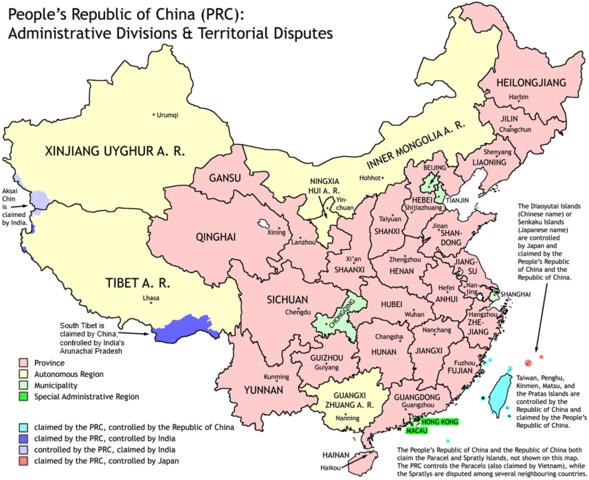
Administrative divisions of China. Made by Ran.
Features:
- Latest borders as of 2004. Qinghai-Gansu border readjustments are reflected; Sino-Russian agreement on the Amur-Ussuri delta is also (approximately) reflected.
- Disputed areas are given as neutral a treatment as possible.
The map was made based on a large-scale map of China made by woodhome and hunry of the XZQH forums.
Looking for translators!: If you want to translate the map into another language, here's a blank map that you can work with:
Alternatively, you can message me with the translated texts, and I will incorporate your translations for you and credit you for your work. (You don't have to translate the place names; I'll attempt to get them, as far as possible, from the Wikipedia in that language.) Same goes for any additions or corrections you'd like to make.
Translations have already been done for Spanish, German, Chinese (Simplified/Traditional), Japanese, French, Russian, Macedonian, Vietnamese, and Hebrew.
See also: en:Wikipedia:WikiProject Chinese provinces/Locator maps

|
อนุญาตให้คัดลอก แจกจ่ายและ/หรือดัดแปรเอกสารนี้ภายใต้เงื่อนไขของสัญญาอนุญาตเอกสารเสรีของกนู รุ่น 1.2 หรือรุ่นใด ๆ นับจากนี้ที่ออกโดยมูลนิธิซอฟต์แวร์เสรี โดยไม่มีส่วนใดห้ามแก้ไข ไม่มีข้อความปกหน้าและปกหลัง สำเนาของสัญญาอนุญาตรวมอยู่ในส่วนชื่อ สัญญาอนุญาตเอกสารเสรีของกนู |
| ไฟล์นี้อยู่ภายใต้สัญญาอนุญาต ครีเอทีฟคอมมอนส์ แบบแสดงที่มา-อนุญาตแบบเดียวกัน 3.0 ต้นฉบับ | ||
| ||
| ป้ายแสดงสถานะลิขสิทธิ์นี้ถูกเพิ่มเพื่อให้เป็นไปตามการเปลี่ยนแปลงสัญญาอนุญาตของมูลนิธิวิกิมีเดีย จาก GFDL ไปยัง GFDL ควบคู่กับ CC-BY-SA 3.0 |
ประวัติไฟล์
คลิกวันที่/เวลาเพื่อดูไฟล์ที่ปรากฏในขณะนั้น
| วันที่/เวลา | รูปย่อ | ขนาด | ผู้ใช้ | ความเห็น | |
|---|---|---|---|---|---|
| ปัจจุบัน | 02:43, 2 ตุลาคม 2554 | | 857 × 699 (95 กิโลไบต์) | Quigley | Southwest disputed area has its own name |
| 03:13, 27 สิงหาคม 2550 |  | 857 × 699 (83 กิโลไบต์) | Ran | {{Information |Description= |Source= |Date= |Author= |Permission= |other_versions= }} | |
| 20:52, 16 ธันวาคม 2549 |  | 857 × 699 (83 กิโลไบต์) | Electionworld | {{ew|en|Ran}} Administrative divisions of China. Made by Ranr. Features: * Latest borders as of 2004. {{link|Qinghai}}-{{link|Gansu}} border readjustments are reflected; Sino-Russian agreement on the Amur-Ussuri delta is also (approxim |
หน้าที่มีภาพนี้
หน้าต่อไปนี้ โยงมาที่ภาพนี้:
การใช้ไฟล์ข้ามโครงการ
วิกิอื่นต่อไปนี้ใช้ไฟล์นี้:
- การใช้บน avk.wikipedia.org
- การใช้บน bg.wikipedia.org
- การใช้บน blk.wikipedia.org
- การใช้บน bs.wikipedia.org
- การใช้บน ca.wikipedia.org
- การใช้บน cs.wikipedia.org
- การใช้บน cu.wikipedia.org
- การใช้บน el.wikipedia.org
- การใช้บน en.wikipedia.org
- China
- User talk:Yug/Archive01
- File talk:India-locator-map-blank.svg
- User:Ahmadiskandarshah
- User:Palaeovia/sinology
- User:Jonny-mt/Gallery of current first-level administrative country subdivisions maps
- Template:PRC provinces big imagemap
- Outline of China
- Talk:Renminbi/Archive 1
- Talk:Chinese civilization/Archive 26
- User:Riley.W.Uhr/sandbox
- User:Falcaorib
- User:Centralismo
- User talk:FuzionEXA
- User:Sanskar shingare/sandbox
- การใช้บน en.wikibooks.org
- การใช้บน en.wikinews.org
- การใช้บน eu.wikipedia.org
- การใช้บน fa.wikipedia.org
- การใช้บน hr.wikipedia.org
- การใช้บน hy.wikipedia.org
- การใช้บน incubator.wikimedia.org
- การใช้บน lt.wikipedia.org
- การใช้บน mn.wikipedia.org
- การใช้บน ms.wikipedia.org
- การใช้บน mwl.wikipedia.org
- การใช้บน my.wikipedia.org
- การใช้บน pam.wikipedia.org
- การใช้บน pt.wikipedia.org
- การใช้บน qu.wikipedia.org
- การใช้บน ro.wikipedia.org
- การใช้บน sd.wikipedia.org
ดูการใช้ข้ามโครงการเพิ่มเติมของไฟล์นี้